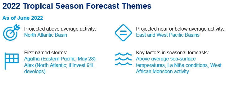
June 1 marks the official start to the Atlantic Hurricane season. Following on the heels of two very active hurricane seasons in 2020 and 2021, above average activity is again anticipated by the majority of forecasting entities.
Key Headlines
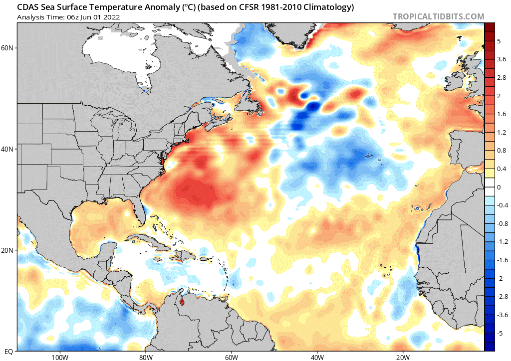
- Predictions for this year's Atlantic hurricane season are more aggressive than those of last year, and well above the 1950-2021 average. Above average sea-surface temperatures in the Atlantic Main Development Region, La Niña conditions, and enhanced West African Monsoon activity are all factors for the above average outlook.
- Meanwhile in the Eastern Pacific, where the hurricane season officially began on May 15, the first named storm of the season has already run its course. Hurricane Agatha made landfall in Mexico on Monday, May 30 as a category-2 hurricane with maximum sustained winds of 105 mph. Agatha brought heavy rain and strong winds, particularly to parts of Oaxaca and stands as the strongest hurricane to make a May landfall on the Pacific coast of Mexico.
- Outlooks for the Western North Pacific cite La Niña conditions as a substantial factor leading to a below average forecast.
Atlantic Forecasts
Seasonal outlooks for the 2022 North Atlantic Hurricane season are shown below, from:
- National Oceanic and Atmospheric Administration (NOAA)
- UK Met Office (UKMet)
- Colorado State University (CSU)
- The Weather Company (TWC)
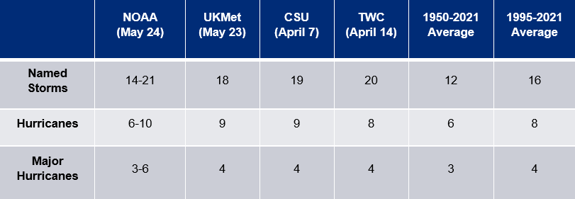
The 1950-2021 average represents a longer-term period where hurricane detection in the North Atlantic Basin includes overflight data, and then satellite data from about 1970 onwards. The 1995-2020 average is reflective of the current active period of Atlantic hurricane activity that began around 1995.
What to watch for:
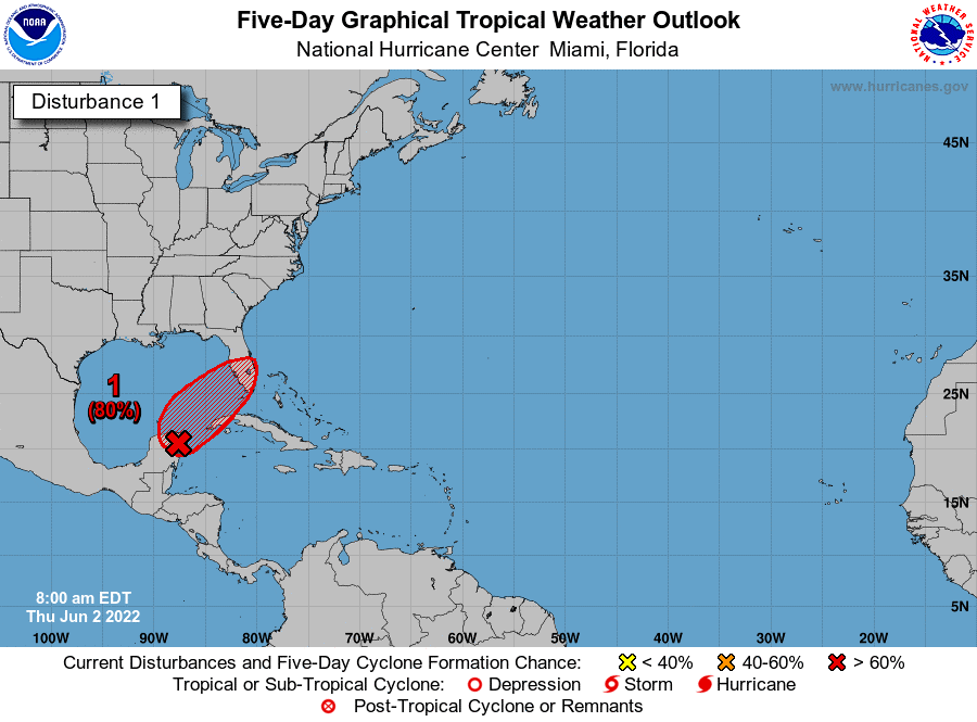
- In the short term: All eyes are on the potential development of Invest 91L, the remnants of Hurricane Agatha, which moved east over the Yucatan Peninsula and the northwestern Caribbean Sea. Favorable environmental conditions are leading to an 80% of chance of development over the next 48 hours, as the system moves northeastward, per the National Hurricane Center (NHC). If development occurs, the system will be named Alex and mark the first named storm of the Atlantic season. Interests in western Cuba, the Florida Keys and the Florida Peninsula should monitor the system through the weekend.
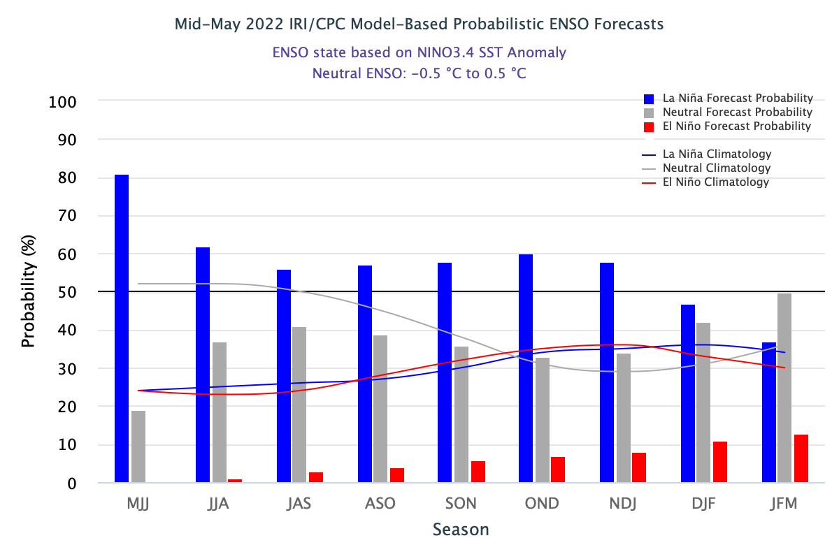
- In the long term: The progression of the El Niño Southern Oscillation (ENSO) through the summer and fall months plays a key role in hurricane activity. Under La Niña conditions, enhanced hurricane activity in the North Atlantic Basin is typically observed due to reduced wind shear in the areas where hurricanes form and strengthen. Wind shear tends to inhibit hurricane activity, therefore reduced wind shear conditions provide a better environment for hurricane strengthening and development. ENSO forecasts call for a strong probability (>50%) of La Niña conditions remaining in place through the end of hurricane season.
- For an active event: The potential for landfall depends on a variety of factors, including daily weather patterns and related steering currents. Weather prediction for any event generally loses skill beyond 7 day forecast lead. For the most up to date information at any point, a link to the NHC can be found here.
- Throughout the season: Guy Carpenter meteorologists will periodically publish commentary on current storms, especially those with the potential for significant impacts at category-1 or stronger intensity. In the event that 91L poses a material threat to the US as a hurricane, a Live Event Report will be issued in the coming days.
What to watch for:
- In the short term: All eyes are on the potential development of Invest 91L, the remnants of Hurricane Agatha, which moved east over the Yucatan Peninsula and the northwestern Caribbean Sea. Favorable environmental conditions are leading to an 80% of chance of development over the next 48 hours, as the system moves northeastward, per the National Hurricane Center (NHC). If development occurs, the system will be named Alex and mark the first named storm of the Atlantic season. Interests in western Cuba, the Florida Keys and the Florida Peninsula should monitor the system through the weekend.
- In the long term: The progression of the El Niño Southern Oscillation (ENSO) through the summer and fall months plays a key role in hurricane activity. Under La Niña conditions, enhanced hurricane activity in the North Atlantic Basin is typically observed due to reduced wind shear in the areas where hurricanes form and strengthen. Wind shear tends to inhibit hurricane activity, therefore reduced wind shear conditions provide a better environment for hurricane strengthening and development. ENSO forecasts call for a strong probability (>50%) of La Niña conditions remaining in place through the end of hurricane season.
- For an active event: The potential for landfall depends on a variety of factors, including daily weather patterns and related steering currents. Weather prediction for any event generally loses skill beyond 7 day forecast lead. For the most up to date information at any point, a link to the NHC can be found here.
- Throughout the season: Guy Carpenter meteorologists will periodically publish commentary on current storms, especially those with the potential for significant impacts at category-1 or stronger intensity. In the event that 91L poses a material threat to the US as a hurricane, a Live Event Report will be issued in the coming days.

Additional links of interest:
Colorado State Seasonal Hurricane Forecasts
NOAA Seasonal Hurricane Outlook (North Atlantic)
NOAA Seasonal Hurricane Outlook (Eastern Pacific)
Guy Carpenter Asia-Pacific Climate Impact Centre
Barcelona Supercomputing Center Catalog of Seasonal Atlantic Forecasts
If you would like to change which emails you receive from Guy Carpenter please update your subscription preferences.