
Summary
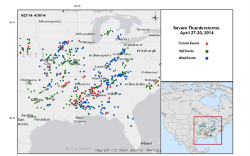
A multi-day severe weather outbreak rendered severe impacts from April 26 to 30 affecting a large area of the United States. The outbreak is occurring along a powerful spring frontal system that evolved from the Southern Rockies and pressed towards the Southern Great Lakes and is now affecting the Atlantic Coast. According to the U.S. Storm Prediction Center (SPC), there are widespread reports of straight-line (nontornadic) wind and hail over the Southern States, Midwest and Lower Great Lakes. Tornado reports are widespread, with strong to violent tornadoes reported in states including Alabama, Arkansas, Kansas, Tennessee, Iowa and Mississippi. Severe flooding has also been reported in Alabama and Florida.

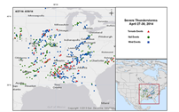
Preliminary severe weather reports from April 27 to 30. Source: U.S. Storm Prediction Center (NOAA)
It is too early to ascertain the full scope and extent of the damage of this event, and no initial loss estimates have been disseminated. Damage assessments, recovery efforts, and National Weather Service (NWS) tornado damage surveys are still ongoing and it will take time to consolidate the results of their efforts. The aggregate financial impacts of light to moderate roof and tree damage over a large area may be considerable. The severe tornadic damage to areas such as the Mayflower, Arkansas and Tupelo, Mississippi areas will also impose notable losses as these areas have sustained severe to complete damage. At least 34 fatalities have been inflicted by this event, with well over 200 injuries. Our first thoughts and concerns are with those lives lost or affected by this outbreak.

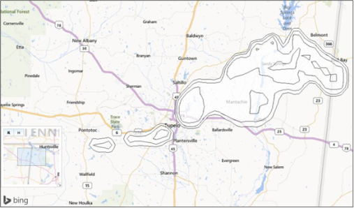
Tupelo, MS possible storm path (radar estimated). The storm produced an EF-3 tornado (NWS). Source: i-aXs.

Hazard data illustrated in the CAT-i map was taken from i-aXs®, Guy Carpenter's web-based risk management platform. i-aXs users can view impacted areas on any map as well as see how their portfolios were affected. Please contact your broker or GC Analytics® representative for assistance or go to www.i-axs.info for further information.
Meteorological Discussion
After an exceptionally slow start to the 2014 season, an aggressive severe convective event developed from April 26 to 30 affecting a large area of the United States including Texas, Florida, the Lower Great Lakes and the Midwest. Tornado reports are widespread and include NWS assessments of an EF-4 tornado affecting the Mayflower, Arkansas region, an EF-3 near Jackson, Mississippi and another EF-3 affecting the Tupelo, Mississippi area. An EF-4 affected the Louisville, Mississippi area (NWS). Hail reports were widespread and as far north as Michigan and include baseball sized hail near Canton, Texas, Lee Co., Texas, and even softball sized hail in Atlanta, Texas. Wind reports were widespread through the Midwest and Lower Great Lakes, with wind gusts exceeding 74 mph near Sabina, Ohio and near Hilliard, Ohio. Flash-flooding was a widespread problem with excessive and intense rainfall, particularly in the West Florida Panhandle.
This severe weather outbreak was enabled along a powerful spring frontal system separating cold and dry from warm and moist air. Severe thunderstorms are enabled by the presence of warm, moist air at the surface, cold air at flight level, and wind shear (changing wind speed and ideally wind direction with height). The air currents associated with this system were particularly aggressive, allowing these enabling conditions to remain in place and abundantly so over a multiday period. Given the aggressive conditions in place, it is notable that the outbreak could have been far worse. Severe weather remains possible on April 30 from Maryland to South Carolina, although less aggressively than recent events. The flash-flood risk remains a threat in the Florida Panhandle with ongoing heavy rainfall.
Regional Summary
Arkansas
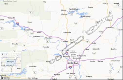
On Sunday, April 27, a tornado hit Vilonia and nearby Mayflower in Arkansas. NWS survey teams assessed this tornado as an EF-4. Emergency crews had to claw through the debris overnight in some of the hardest-hit areas. The central part of the town of 4,000 was said to be completely levelled. Gas lines and fire lines were affected according to reports. In addition to Vilonia, tornados also devastated large sections of the town of Mayflower, population 2,300, just northwest of the Arkansas state capital Little Rock.
Reports indicate that at least 15 people died in Arkansas in the storm that authorities said produced the first fatalities of this year's tornado season, according to Governor Mike Beebe. Medical officials reported at least 100 people in Arkansas were injured. President Obama declared a disaster for Arkansas Tuesday afternoon, sending federal aid to assist in state and local recovery efforts.
Oklahoma
Reports indicate that a tornado struck the town of Quapaw, Oklahoma, on Sunday, April 27, damaging or destroying about 60 buildings in the town of 900, including Quapaw's volunteer fire department station and a bank. Monday afternoon, an NWS survey crew rated the tornado as an EF2.
Although cleanup and rescue efforts are ongoing, reports indicate the town does not have electricity and that authorities are concerned about the water supply and have asked residents to conserve water. Oklahoma Governor Mary Fallin declared a state of emergency Monday for Ottawa County following the Quapaw tornado. At least two people were killed and six were injured according to reports.
Iowa
There were reports of tornado sightings northeast of Mount Vernon, Iowa on the afternoon of Sunday, April 27, with another sighting near Floris, Iowa. At least one farm near Wapello sustained damage to the roof and porch. South of Udell, several farm buildings were damaged or destroyed as the storms moved through. Tornadoes also dumped heavy rain, snapped trees and lifted the roof off the Oskaloosa Family Medical Center in Mahaska. Several trees about one-foot in diameter were snapped off. Reports indicate an NWS rating of EF-1 with an estimated peak wind of 108 mph and a distance travelled of more than 40 miles.
The Keokuk County Sheriff's Office confirmed two fatalities from the Sunday tornado.
Mississippi
At least nine tornadoes struck Mississippi on Monday, April 28, including an EF-4 in Louisville and EF-3 tornadoes in Tupelo and Richland, according to the NWS. Survey efforts by ground survey teams are ongoing.
In the Mississippi town of Louisville, the storm snapped trees in half and stripped them of their branches. Sheet metal twisted itself around road signs and tree trunks. The tornado that hit Tupelo left a 24-mile-long swath from 7 miles south-southwest of Tupelo to the town of Ozark in Itawamba County, damaging hundreds of homes and businesses, downing power lines and shredding trees.
Tennessee
A probable tornado damaged Lincoln County High school and area homes on Monday, April 28, in Lincoln County, Tennessee, near the Alabama state line. Monday night's tornado started near the Alabama line and cut a path to the northeastern corner of the county. The NWS has not yet made a final assessment of the tornado intensity, but set a preliminary rating of EF-3 with winds between 136 mph and 165 mph. A probable tornado also hit about 80 miles east of Nashville.
Governor Bill Haslam planned to survey the devastation wrought by the Lincoln County tornado on Wednesday, which left two dead and at least 25 homes and one elementary school destroyed according to reports.
Kansas
On Sunday, April 27, a tornado that tore through the southeastern Kansas town of Baxter Springs left more than 100 homes and 12 businesses damaged. The tornado struck around 5:45 p.m., cutting a diagonal through the town of about 4,200 people. The storm, reported unofficially to be 2 miles long and 2 blocks wide, also left behind mounds of debris, twisted metal and hanging power lines. Baxter Springs is located about six miles north of Quapaw, Oklahoma, where the same tornado struck just before hitting the Kansas town. The tornado was given a preliminary EF-2 rating by the NWS on Monday.
On Monday, workers were restoring power to about 40 percent of the community and to 91 residents whose gas was disconnected after the tornado. There were no serious injuries or deaths from the storm, but 25 people were reported as having minor injuries.
Florida
Severe floods in the Florida Panhandle and coastal Alabama inundated roads and engulfed homes and cars on Wednesday, April 30 according to reports. The flooding could be the worst in 30 years in the Panhandle, evidenced by initial radar estimates of the rainfall, according to the NWS. Emergency workers received about 300 calls for evacuations in the Panhandle, where up to 22 inches of rain fell in recent days. Florida Governor Rick Scott declared a state of emergency for 26 counties inundated by as much as 1 to 3 inches of hourly rain.
Alabama
Along the Alabama Gulf Coast, major county roads were reported flooded and several rivers overflowed after some areas got between 22 and 26 inches of rain in 24 hours. Gulf Shores, Alabama unofficially received nearly 21 inches of rain in 24 hours. Waters of the Intracoastal Waterway rose, reaching the canal road linking the town with neighboring Orange Beach. In addition, an estimated EF-1 tornado was confirmed in the Kimberly community, north of Birmingham, and a possible tornado struck near Tuscaloosa on the night of Monday April 28. Reports indicate that Limestone County saw a tornado that left EF-3 damage, as confirmed by a NWS survey team (with winds as high as 165 mph).
At least 240 homes were reported damaged or destroyed by the tornadoes and strong storms that swept through Alabama. The greatest reported concentration of destruction was the Smith Institute community of Etowah County, where between 100 and 150 homes were damaged or destroyed. Another 90 homes were hit in Blount County. As of April 30 the state reported more than 33,000 homes and businesses without electrical service, down from a peak of more than 97,000. Three people were reported killed in Alabama during the storms.
Georgia
Reports indicate that residents in Troup and Heard counties were recovering from a confirmed tornado on the night of Monday, April 28. The tornado carved an approximate 5.5-mile path of damage across western Georgia. A survey crew at the NWS announced Tuesday that the tornado was an EF-2, with winds as high as 120 mph.
Kentucky
According to reports, the NWS determined that injuries and damage on Monday, April 28, in Harlan County were caused by 90 mph straight-line winds. The NWS said the storm caused three minor injuries and damaged three buildings in Evarts, including one building hit by a tree. Numerous trees were also reported damaged. The storm also downed power lines and caused power outages in the county.
Louisiana
Reports indicate that a tornado touched down in rural northwest Louisiana around 3:15 a.m. on Monday, April 28, about six miles west of Plain Dealing. One home was severely damaged, and minor injuries were sustained by one resident of the home.
Missouri
According to reports, a large tornado was visually identified on live television Sunday April 27, about 70 miles south of Kansas City on the Kansas/Missouri line in Linn and Bates counties.
North Carolina
Reports indicate at least five counties with tornadoes on Tuesday, April 29. Fire department officials said lightning strikes caused two fires. A number of roads were closed for a time, but most were open as of Wednesday morning. Seven buildings at Fayetteville State University suffered flooding on the ground floors.
Ohio
Winds picked up and flipped a mobile home in the community of Bellville in Richland County, south of Mansfield according to reports. In the town of Delaware, just north of Columbus, a roof was blown off a downtown building and onto a car parked on the street. Downed tree limbs also closed a road in Delaware. Scattered power outages were reported in central Ohio overnight. Heavy rain also led to flash flood warnings for parts of central and southeast Ohio early Wednesday.
Virginia
Reports indicate that in southwest Virginia, there were flash flood watches in effect for numerous cities and counties. Multiple counties in central Virginia were also under a flood watch from Tuesday evening through late Wednesday night, April 30. That includes parts of south central Virginia and the piedmont of central Virginia.
Sources: U.S. National Weather Service (NOAA), U.S. Storm Prediction Center (NOAA), Associated Press, Reuters, Agence France Presse.
Guy Carpenter publishes CAT-i reports for major natural catastrophes worldwide. These reports cover catastrophes including worldwide tropical cyclones, earthquakes, major UK and European floods and any other natural event that is likely to incur a significant loss to the (re)insurance industry. Please email mailto:CAT.i@guycarp.com if you wish to be added to the free email distribution list.
Guy Carpenter compiles RISK-i reports for major technological or man-made events worldwide. These reports cover risks to property, transport and life including explosions, fires, crashes, engineering disasters and terrorist attacks that are likely to incur a significant loss to the (re)insurance industry. Please email RISK.i@guycarp.com if you wish to be added to the free email distribution list.