
Summary
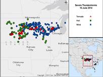
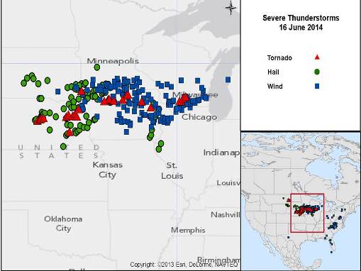
An especially volatile environment produced a violent severe weather outbreak yesterday affecting areas of Nebraska, Iowa and Wisconsin. Severe to complete property damage was reported in Pilger, Nebraska and surrounding areas. Initial evidence indicates two tornadoes in close proximity near Pilger, with EF-2 to EF-3 intensities. Tornadoes were also reported in Southern Wisconsin where severe damage occurred. Hail and straight-line (nontornadic) wind reports also covered a very widespread area, with reports of hail exceeding two inches in diameter and wind gusts exceeding 74 mph. National Weather Service survey teams are scheduled to survey affected areas today to confirm tornado paths and intensities (a process that can take several days).

Source: U.S. Storm Prediction Center (NOAA)
Hazard data illustrated in the CAT-i map was taken from i-aXs®, Guy Carpenter’s web-based risk management platform. i-aXs users can view impacted areas on any map as well as see how their portfolios were affected. Please contact your broker or GC Analytics® representative for assistance or go to www.i-axs.info for further information.
The severe weather threat continues today (with reduced volatility) from the High Plains through the Great Lakes and Southern Ontario Canada to the Atlantic Coast.
Meteorological Discussion
The enabling conditions of this severe weather outbreak were especially volatile. Warm, moist air at the surface, cold air at flight level, and wind shear (changing wind speed and direction with height) brought optimal conditions for severe thunderstorms. These enabling conditions were focused along a nearly stationary frontal boundary crossing the Midwest. Changing wind direction with height and excessive instability were an unusually potent combination. As a result, the U.S. Storm Prediction Center (SPC) issued a rare "particularly dangerous situation" tornado watch for Northeast Nebraska late afternoon of June 16, together with a collection of other watches across the affected areas.
According to SPC preliminary reports, several tornadoes occurred in Northeast Nebraska, Iowa, North Dakota, and Wisconsin. It appears from preliminary observation that at least two strong tornadoes occurred in very close proximity (a very rare phenomenon) near Pilger, Nebraska. Initial evidence suggests intensities of the EF-2 to EF-3 range according to the National Weather Service (NWS); these intensities have yet to be confirmed. Tornadoes also caused damage in Cuming and Wayne counties in Nebraska, with another reported tornado near Burwell, in central Nebraska. In Wisconsin, initial reports indicate that a probable tornado moved from Green County into southern Dane County shortly after midnight. Initial reports also indicate a tornado near New Glarus in the vicinity of Madison, with part of a roof found in the middle of a highway. NWS damage survey teams are scheduled to assess tornado damage today in affected areas. Following the surveys, it will take a few days to analyze data and determine official tracks and intensities.
Numerous reports of hail and straight-line (nontornadic) wind gusts cover a widespread area. Hail was reported to exceed 2 inches in diameter in Seward, Lancaster and Douglas Counties in Nebraska, Pennington County in South Dakota, and Adams County in Illinois. Hail of 4 inches in diameter was reported in Humbolt County in Iowa. Straight-line (nontornadic) winds exceeding 74 mph were reported in Murray and Jackson Counties in Minnesota, Minnehaha County in South Dakota, and Emmet and Butler Counties in Iowa.
An ongoing severe weather threat remains today (with less volatile conditions) across the Northern Plains, the Upper Mississippi Valley, and the Lower Great Lakes including Southern Ontario Canada to the Atlantic Coast. A line of thunderstorms has already prompted Environment Canada to issue severe thunderstorm watches and warnings in Southern Ontario, where damaging straight-line winds and hail are the primary threats, together with possible isolated tornadoes. Some excessive hail and isolated strong tornadoes are also possible in the Northern High Plains later today.
The severe weather threat continues tomorrow from Texas to North Dakota to the Southern Great Lakes including Southern Ontario Canada to the New Jersey Atlantic coast. Damaging (nontornadic) winds will be the primary threat with probable organized lines of severe thunderstorms. Significant severe weather is possible in the Northern Plains and Upper Mississippi Valley with excessive hail and wind gusts as the primary threat, and the possibility of isolated tornadoes.
The U.S. Storm Prediction Center has identified a slight risk of severe weather for areas under threat for both today and tomorrow.
Impacts
Initial reports include at least two fatalities. One was a 5-year old girl in Pilger, according to the Stanton County Sheriff's Office. The other was a motorist found in a single-vehicle accident in nearby Cuming County. At least 19 people were hospitalized.
In Nebraska, the town of Pilger (population of about 350) suffered a direct hit from one of a probable four tornadoes in the area. It appears from preliminary observation that two strong tornadoes were on the ground in close proximity. According to reports, the first tornado occurred around 3:45 p.m. local time; the tornado downed several power lines before destroying a farmhouse. The second tornado occurred southwest of Pilger, according to the Stanton County Sheriff's Office. The town of Pilger then suffered a direct hit from a tornado. Pilger suffered exceptionally severe to complete property damage with reports of several buildings leveled including the local Fire Department and a school. There were also reports of crushed vehicles. Property damage and injuries cover a three-county area according to reports, with the town of Pilger most severely affected. Pilger is located about 100 miles northwest of Omaha, Nebraska. Tornadoes also caused damage in Cuming and Wayne counties, with another reported tornado near Burwell, in central Nebraska.
Nebraska Governor Dave Heineman has declared a state of emergency for the affected areas. The state Emergency Management Agency said National Guard troops would be deployed to assist local authorities as cleanup efforts begin.
In southern Wisconsin, reports indicate heavily damaged cars, windows and trees, a roof lifted from a home, and power loss to the University of Wisconsin at Platteville. Preliminary reports indicate a tornado near New Glarus, with part of a roof found in the middle of a highway.
Downed trees and power lines, along with property damage were reported across Dane County, Wisconsin, especially along an area from Verona northeast to Madison. In Dane County, Emergency Management officials received about 350 reports of storm damage. Emergency managers indicated the north side of Verona and the southwest side of Madison suffered the most severe damage, with an estimated 15 homes in Verona severely affected.
At least five buildings were damaged on the University of Wisconsin-Platteville campus. Administrators say the university will be closed Tuesday and only essential employees should report to work.
Sources: U.S. National Weather Service (NOAA), U.S. Storm Prediction Center (NOAA), Associated Press, Reuters.
Guy Carpenter publishes CAT-i reports for major natural catastrophes worldwide. These reports cover catastrophes including worldwide tropical cyclones, earthquakes, major UK and European floods and any other natural event that is likely to incur a significant loss to the (re)insurance industry. Please email CAT.i@guycarp.com if you wish to be added to the free email distribution list.
Guy Carpenter compiles RISK-i reports for major technological or man-made events worldwide. These reports cover risks to property, transport and life including explosions, fires, crashes, engineering disasters and terrorist attacks that are likely to incur a significant loss to the (re)insurance industry. Please email RISK.i@guycarp.com if you wish to be added to the free email distribution list.