
Summary
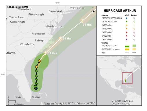
Hurricane Arthur was reclassified as a hurricane overnight by the National Hurricane Center (NHC), and currently carries maximum sustained winds of 90 miles per hour. Arthur is currently moving offshore of the U.S. mainland to the north-northeast at about 10 miles per hour. Hurricane and tropical storm force winds extend outward from the center of circulation to 25 and 115 miles, respectively.
According to the NHC, some further intensification is expected with an increase in forward speed and turn to the northeast tonight and Friday. The core of Arthur is expected to approach the coast of North Carolina in the hurricane warning areas tonight. Arthur is expected to be a Category 2 hurricane as it passes over or near the North Carolina coast. Some weakening should occur into Saturday with extra-tropical transition and eventual landfall in Atlantic Canada during the day Saturday.

The right panel outlines the NHC cone of uncertainty. The left panel highlights areas potentially affected by the tropical storm winds based on the NHC best track. Be aware that the tropical intensity can change under a very short timeframe and one should closely monitor NHC updates for their area of interest.
Hazard data illustrated in the CAT-i map was taken from i-aXs®, Guy Carpenter’s web-based risk management platform. i-aXs users can view impacted areas on any map as well as see how their portfolios were affected. Please contact your broker or GC Analytics® representative for assistance or go to www.i-axs.info for further information.
While the projected path of the NHC indicates a near-miss or actual landfall along Eastern North Carolina, it is possible that a slight shift to the west of the hurricane track could cause more inland areas of the Carolinas to be affected. Interests in potentially affected areas from the Carolinas to Atlantic Canada should monitor statements of the NHC and local National Weather Services offices closely, particularly concerning matters of personal safety.
Concerning hazards, hurricane wind conditions are expected by the NHC as early as tonight, with onset of tropical storm conditions as early as this afternoon. A storm surge is expected to affect the coastal Carolinas and extreme southeastern Virginia, with peak surge levels of up to five feet within the hurricane warning area, including the Outer Banks. Actual inundation heights depend on timing of the hurricane, the period of onshore flow, and timing with tidal cycles. Heavy rainfall is expected along the Carolinas Friday, with peak amounts of five to seven inches in North Carolina. Some isolated tornadoes are also possible.
Meteorological Discussion
According to the NHC, Arthur is forecasted to intensify over the next 24 hours due to warm waters and low shear. As a result, the forecast calls for Arthur to reach Category 2 strength prior to its landfall or closest approach to the coast. Once past this area, Arthur is expected to weaken due to cooler waters north of the Gulf Stream and an increased shear as it interacts with a deep-layer trough that will be moving off the East Coast of the United States. Arthur should then steadily weaken into a strong extra-tropical cyclone in the next 48 hours.
Current aircraft and radar data indicate Arthur moving faster and turning to the north-northeast. The hurricane is forecasted to turn north-eastward later in the day and graze the North Carolina Coast within the next 24 hours. However, a slight westward deviation in the track could bring the strongest winds inland over Eastern North Carolina. The forecast track then brings the center of the cyclone near or over portions of Nova Scotia and Newfoundland within the next 48 to 72 hours.
Hazards, Watches, Warnings
A hurricane warning has been issued for Surf City, North Carolina to the North Carolina/Virginia border, as well as areas surrounding the Pamlico and Eastern Albemarle Sounds. A hurricane watch is in effect for Little River Inlet to South of Surf City, North Carolina.
Tropical storm warnings have been issued for the area south of the Santee River in South Carolina to south of Surf City, North Carolina, the North Carolina/Virginia border to Cape Charles Light, Virginia, as well as the mouth of Chesapeake Bay and the Western Albemarle Sound.
Tropical storm conditions are expected to reach and travel in a northerly direction through the tropical storm and hurricane warning areas later today and tonight. By tonight, hurricane conditions will have reached portions of the hurricane warning area and hurricane-force winds will be possible in the hurricane watch area in the evening.
A combination of the tide and a dangerous storm surge could produce surge levels of up to five feet for the coast of North Carolina within the hurricane warning area. A surge of two to four feet is expected for areas around the Pamlico and Albemarle Sounds. The area between Southern North Carolina and North-eastern South Carolina could experience surge levels between one and three feet, while extreme South-eastern Virginia could see surge levels of up to two feet.
Areas of onshore flow along the immediate coast will experience the highest water levels. The degree of surge-related flooding will depend on the timing of the tidal cycle and the surge.
Rainfall accumulations of three to five inches, and up to seven inches, are expected over coastal areas of North Carolina through Friday. The upper coast of South Carolina could see rainfall accumulations of up to two inches.
Isolated tornadoes are also possible over portions of the North Carolina Coast through tonight.
Impacts
North Carolina Governor Pat McCrory declared a state of emergency for 25 counties to allow for faster restoration of power and debris removal. Over 100 National Guardsmen have been approved for deployment in response to the hurricane.
A mandatory evacuation has been issued for visitors to Hatteras Island, North Carolina. Residents have been advised to leave the island as well. A voluntary evacuation was announced for Ocracoke Island, North Carolina, which is accessible only by ferry.
Sources: Reuters, Associated Press, U.S. National Weather Service, U.S. Storm Prediction Center
Guy Carpenter publishes CAT-i reports for major natural catastrophes worldwide. These reports cover catastrophes including worldwide tropical cyclones, earthquakes, major UK and European floods and any other natural event that is likely to incur a significant loss to the (re)insurance industry. Please email CAT.i@guycarp.com if you wish to be added to the free email distribution list.
Guy Carpenter compiles RISK-i reports for major technological or man-made events worldwide. These reports cover risks to property, transport and life including explosions, fires, crashes, engineering disasters and terrorist attacks that are likely to incur a significant loss to the (re)insurance industry. Please email RISK.i@guycarp.com if you wish to be added to the free email distribution list..