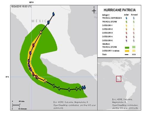

Hurricane Patricia made landfall on the Pacific Coast of Mexico as a Category 5 hurricane on the Saffir-Simpson Scale. Patricia was a compact storm, and made landfall in an area of relatively low population density. Reported impacts in the immediate landfall area are severe. However, the track and compact nature of Patricia appears to have spared Puerto Vallarta, Manzanillo and Guadalajara from the most severe impacts, according to media reports.
Meteorological Discussion
Hurricane Patricia is the most intense hurricane in the observed history of the North Atlantic or Northeast Pacific basins. Maximum-sustained winds reached 200 mph, a Category 5 on the Saffir-Simpson Scale.

NHC track and wind history.
Patricia was first classified by the National Hurricane Center (NHC) as a tropical depression on October 20, about 250 miles southeast of Puerto Escondido, Mexico. The tropical depression was upgraded to tropical storm status 12 hours later, as it followed a generally west to west-northwesterly track. On October 22 at 4 a.m. CDT, Patricia was then upgraded to hurricane status.
Over the next 24 hours, Patricia underwent a period of exceptionally rapid intensification enabled by high oceanic heat content and low wind shear. Maximum sustained winds increased from 85 mph to 200 mph during this time, with a drop in central pressure from 980 mb to 880 mb. Patricia began a slow turn from the west-northwest to north-northwest during this time, offshore of the Mexico Pacific Coast.
During the morning of October 23, Patricia turned to the north and maintained strength with 200 mph winds. By 4 p.m. CDT, Patricia was beginning to lose strength with land interaction, but still carried winds of 190 mph.
According to the NHC, Hurricane Patricia made landfall at about 6:15 p.m. CDT (2315 UTC) on October 23. Patricia made landfall near Cuixmala, Mexico, about 55 miles west-northwest of Manzanillo, Mexico. The NHC reported maximum sustained winds at landfall of 165 mph (one minute sustained over water), a Category 5 on the Saffir-Simpson Scale. The central pressure at landfall was reported by the NHC as 920 mb. Patricia was a compact storm, with hurricane and tropical-storm force winds extending from the center of circulation to 35 and 175 miles, respectively.
As Patricia moved inland over the mountainous terrain of Mexico, land and topography interaction caused rapid weakening. On October 24, Patricia was classified as a tropical storm at 7 a.m. CDT, and then a tropical depression at 10 a.m. CDT. Patricia then dissipated by 4 p.m. CDT.
A frontal system (non-tropical) then absorbed the remnants of Patricia while producing a significant rainfall event over the Northwestern Gulf. Rainfall amounts have exceeded 20 inches in areas of Texas, with amounts exceeding 10 inches across a broad area of Texas and Louisiana. The heavy rainfall threat continues today across the North-Central Gulf.
Impacts
Mexico
Hurricane Patricia made landfall as a Category 5 on the Saffir-Simpson scale, in the state of Jalisco near the town of Cuixmala. This is a relatively low-population area that sustained considerable damage. However, Patricia was a very compact storm, and the nearest major cities of Manzanillo and Puerto Vallarta were spared hurricane-force winds and did not sustain serious damage, according to media reports.
Most of the damage occurred in small rural villages, where there were reports of uprooted trees, flooding, and landslides. President Enrique Pena Nieto stated that over 3,000 homes had been damaged from the storm, as well as 3,500 hectares (8,649 acres) of farmland, according to media reports. Nearly 235,000 lost power when the storm hit, half of which was restored by Saturday. In the town of Chamela, 50 homes were destroyed and residents remain in shelters.
In Manzanillo, a major transit point for Mexico's exports, media reports indicate no major damage. However, there were reports of blown out windows, downed trees and utility poles, and some building damage.
The airport reopened on Saturday in Puerto Vallarta, where 15,000 tourists were evacuated ahead of the storm. No major damage was reported according to media reports.
United States
The remnants from Patricia combined with another frontal system to cause heavy rain in southeastern Texas, where some parts of the state received over 20 inches of rain. Some flooding was reported in Houston, where emergency crews responded to a handful of rescues, however, the area did not sustain major damage according to media reports. Nearly 100 flights were cancelled at Dallas/Forth Worth International Airport on Saturday.
In Navarro County, about 50 miles south of Dallas, emergency crews conducted nearly 80 water rescues according to media reports. A major interstate was shut down in parts of the county due to rising waters. Flash flooding also caused a freight train to derail in the area.
In Louisiana, torrential rainfall left nearly 22,000 people without power. Some street flooding has also been reported, as well as coastal flooding from a high tide and storm surge. The National Weather Service issued tornado watches for parts of Louisiana and Mississippi early Monday. A tornado was reported near Larose, Louisiana. However, no serious damage was reported.
Sources: Reuters, Associated Press, National Hurricane Center, National Weather Service, AIR Worldwide, Risk Management Solutions.
Click here to register for e-mail updates from GC Capital Ideas>>
Guy Carpenter publishes CAT-i reports for major natural catastrophes worldwide. These reports cover catastrophes including worldwide tropical cyclones, earthquakes, major UK and European floods and any other natural event that is likely to incur a significant loss to the (re)insurance industry. Please email CAT.i@guycarp.com if you wish to be added to the free email distribution list.
Guy Carpenter compiles RISK-i reports for major technological or man-made events worldwide. These reports cover risks to property, transport and life including explosions, fires, crashes, engineering disasters and terrorist attacks that are likely to incur a significant loss to the (re)insurance industry. Please email RISK.i@guycarp.com if you wish to be added to the free email distribution list.