


The northern Gulf disturbance was upgraded to Tropical Storm Barry, sitting about 90 miles from the mouth of the Mississippi River. The storm was expected to move very slowly to the north and west over the coming days, to move ashore in Louisiana as a hurricane sometime early Saturday. There remained considerable uncertainty on track and especially intensity. Hazards of concern include excessive rainfall, storm surge and resulting flooding with property damage also due to wind. Interests in the area should prepare accordingly. Further details below follow the 2PM (18 UTC) update of the U.S. National Hurricane Center.
Status (2PM EDT/18 UTC Advisory of the NHC)
- Location: About 90 miles south of the Mouth of the Mississippi River
- Maximum sustained winds: 40 miles per hour
- Motion: west at 5 miles per hour
- Minimum central pressure: 1006 mb
- Status: Weak tropical storm, strengthening
Discussion
- The northern Gulf disturbance was upgraded by the NHC to tropical storm status at 11AM EDT (15 UTC) this morning, following considerable development and evidence of a closed circulation in recent hours.
- Concerning track, the storm is expected by the NHC to move to the west with a curve to the north over the coming days. This should take the center of circulation ashore over coastal Louisiana early Saturday, most likely over the Atchafalaya Basin. There remains considerable spread in model track guidance and forecast uncertainty, with a range of solutions between the Texas/Louisiana line and just east of the Pearl River.
- Concerning intensity, the storm is expected by the NHC to encounter modest wind shear, dry air and land interaction, but with very warm waters and good storm ventilation. Accounting for these factors, the NHC best forecast is for slow strengthening, to make landfall as a Category-1 hurricane. Model guidance still shows considerable spread with resulting forecast uncertainty.
- Hazards of concern include excessive rainfall to produce flooding and flash-flooding for affected areas. The slow forward motion of the storm and watersheds near or approaching saturation will compound these effects. Rainfall amounts as high as 10-15 inches are possible per the NHC.
- Coastal flooding due to storm surge is also a concern with resulting inundation and velocity damage to property and infrastructure. Water levels under storm surge could reach 3-6 feet above ground per the NHC.
- Hurricane force winds will render damage to property and infrastructure with most severe effects along and to the right of the track, with more widespread light property damage along with downed trees and powerlines over a more widespread area.
- The NHC and local National Weather Service Offices maintain watches and warnings for areas under potential or immediate threat. Specifics can be found at www.nhc.noaa.gov and www.weather.gov, respectively.
Official watches and warnings, and statements from emergency management agencies supersede this update, and should be closely followed concerning matters of personal safety.
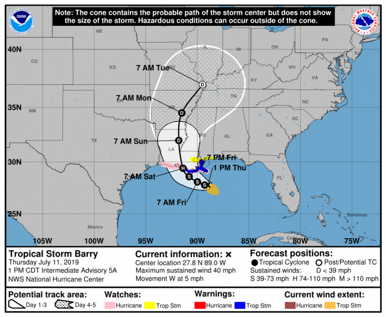
NHC Position and Best Forecast. Source: NOAA/NHC
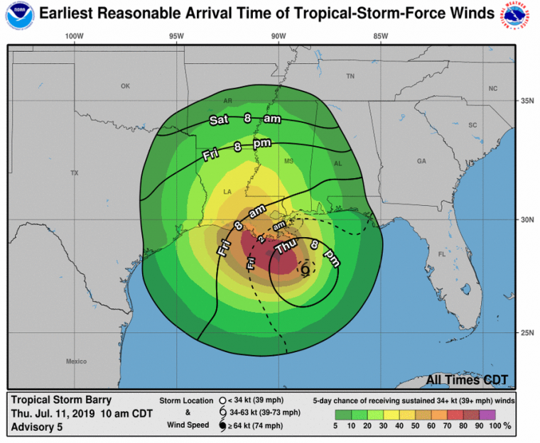
Earliest Reasonable Arrival Time of Tropical Storm Force Winds and Probability of Tropical Storm Winds
Source: NOAA/NHC
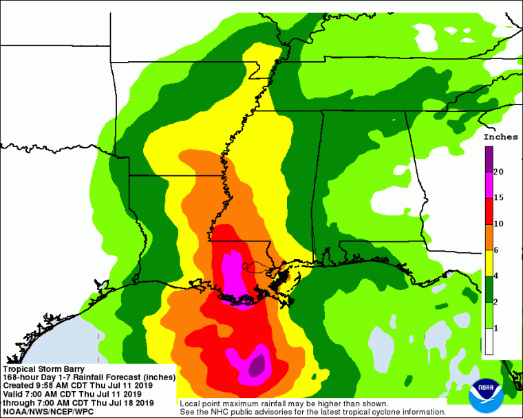
7-Day Precipitation Forecast Ending 8AM EDT (12 UTC) July 18
Source: NOAA/NHC