

An escalating threat for severe thunderstorms affected areas from the Dakotas to the central Great Lakes. The U.S. Storm Prediction Center (SPC) has flagged areas under threat, including a rare moderate risk area for portions of Minnesota and Wisconsin. The Meteorological Service of Canada has also issued severe thunderstorm watches for portions of Southern Ontario.
Threat Overview
The potential exists for destructive long-track significant tornadoes across portions of Minnesota and Wisconsin according to the SPC. Meanwhile, the primary threat is for clustered damaging straight-line wind gusts and possible derecho activity across the threat area. Significant hail of two inches diameter or more is also possible for portions of central Minnesota and extreme northwestern Wisconsin. Further east the primary threat is for damaging wind gusts and large hail.
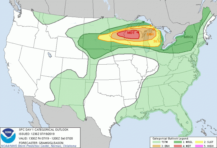
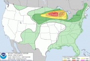
Severe Thunderstorm Outlook - Today Red - Moderate Risk for Severe Thunderstorms Orange - Enhanced Risk for Severe Thunderstorms Yellow - Slight Risk for Severe Thunderstorms Dark Green - Marginal Risk for Severe Thunderstorms Light Green - General Risk for Thunderstorms Source: NOAA/SPC
Discussion
The threat comes with a forecast of very unstable air, abundant moisture and robust wind shear across the threat area, which is a rare combination for deep summer. A stationary front crossing the area, separating hot and humid from cooler and drier air, will act to initiate thunderstorms in the coming hours. Initial thunderstorm activity should be in the form of discrete supercell thunderstorms with the potential to produce destructive long-track significant tornadoes, along with significant hail and destructive wind gusts. Thunderstorm activity should later organize into linear features to favor damaging straight-line wind gusts as the primary threat. Instability and shear characteristics could well produce derecho activity over the threat area. Further east the Meteorological Service of Canada has issued severe thunderstorm watches, primarily for threat of damaging wind gusts and large hail.
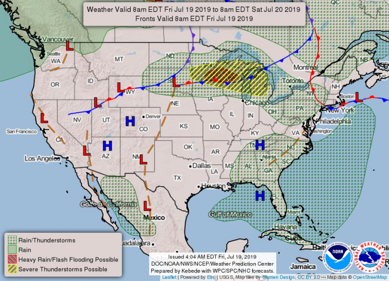
National Forecast Chart - Today
Source: NOAA/WPC
In the meantime, the flood threat continues for portions of the Southern United States and Northern Plains.
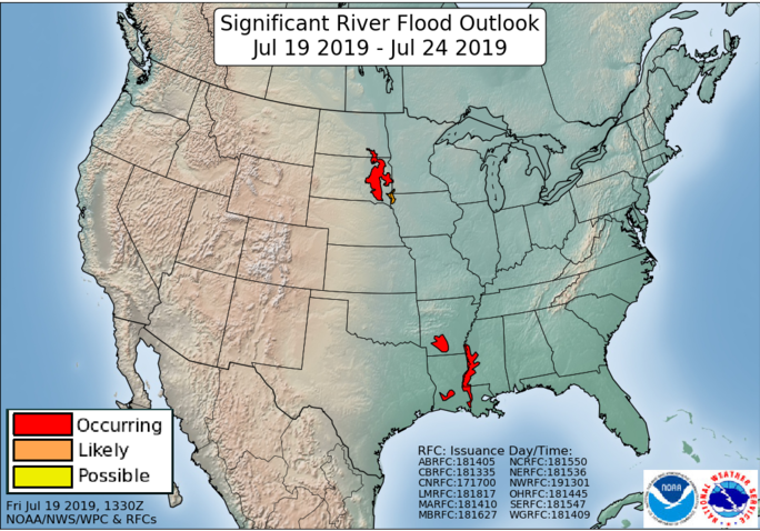
Significant River Flood Outlook - July 19-24
Source: NOAA/WPC
Official watches and warnings, and statements from emergency management agencies supersede this update, and should be closely followed concerning matters of personal safety. Local watches and warnings can be found at www.weather.gov for U.S. locations, and at www.weather.gc.ca for locations in Canada.