

Hurricane Dorian was a strong category-4 hurricane posing an imminent threat to the northwestern Bahamas, for the threat of potentially devastating winds, storm surge and heavy rainfall. The track forecast depended on an expected turn to the north, and the exact timing and placement of this turn carries great uncertainty. The National Hurricane Center (NHC) best forecast takes Dorian on approach to the Florida Atlantic coast early next week before a slow turn to the north. While the NHC best forecast keeps Dorian offshore, a slight shift in track could bring Dorian to Florida Landfall. Regardless of the exact track, impacts can be expected from the Florida Peninsula to the Carolinas.
Further details below follow the 11AM EDT (15 UTC) update of the NHC.
Status (11AM EDT/15 UTC NHC Advisory)
- Location: About 260 miles east-northeast of the northwestern Bahamas
- Maximum sustained winds: 150 mph
- Motion: west at 8 miles per hour
- Minimum central pressure: 945 mb
- Extent of hurricane-force winds: 30 miles
- Extent of tropical-storm-force winds: 115 miles
- Status: Strong category-4 hurricane, strengthening
Discussion
After a remarkable improvement in structure and a period of rapid intensification yesterday, Dorian gained status as a category-4 hurricane on the Saffir-Simpson Scale. The storm retains status today as a strong category-4 with maximum sustained winds of 150 mph per the NHC. Dorian is now moving to the west at 8 mph. A general motion to the west or west-northwest should continue for the short term with a reduction in forward speed. This should take the core of Dorian near or over the northwestern Bahamas on Sunday, with severe impacts expected for the Islands.
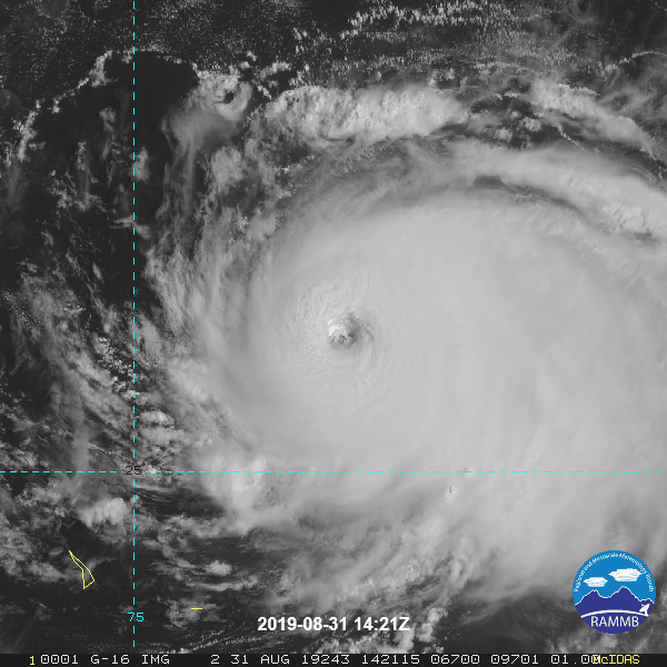
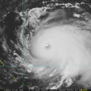
Satellite image of Dorian (visible) ending 11:51 EDT (1551 UTC) August 31. Source: NOAA/NESDIS
For the longer term, a turn to the northwest and north is expected, and the timing and placement of this turn carries great uncertainty. Factors in play include a developing break in the west-Atlantic ridge, a disturbance approaching from the mainland, and the timing and interaction of these features with Dorian. A range of scenarios are possible, including landfall on the Central Florida Atlantic coast, to passage east of the North Carolina Outer Banks. Model guidance shows considerable spread and there is reduced confidence in the track forecast.
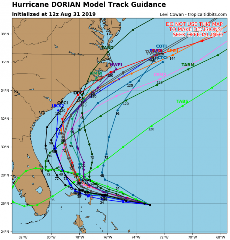
Track model guidance for Dorian. Source: tropicaltidbits.com
Accounting for these factors and model bias, the NHC best forecast takes Dorian on approach to the Florida Atlantic coast late Monday into Tuesday before a turn toward the Carolinas later in the week. While the current best forecast keeps the storm offshore through the middle of next week, a direct landfall remains very possible with a slight shift in track. The storm will also be expanding during this time, and regardless of the exact track impacts remain probable from Florida to the Carolinas. Adjustments to the forecast should be expected as conditions evolve and forecast confidence improves.
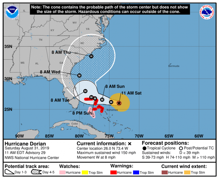
Position and Best Forecast. Source: NHC
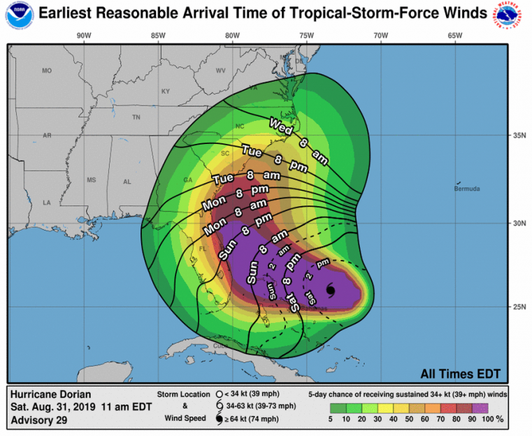
Earliest reasonable arrival time of tropical-storm-force winds and probabilities. Source: NHC
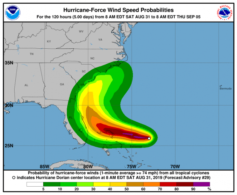
Probability of hurricane-force winds. Source: NHC
Concerning intensity, Dorian will be moving through an environment of high ocean heat content (warm waters of depth) and reduced wind shear. In the meantime the storm will begin to experience eyewall replacement cycles which tend to cause variation in intensity. Accounting for these factors, the NHC is expecting some varied gain in intensity over the next 48-72 hours, which maintains Dorian as a strong category-4 or perhaps even a category-5 hurricane. After 72 hours, the storm should be turning north with a possible increase in wind shear, and this should bring gradual weakening into next week. Intensity guidance is in reasonable agreement for the short term, with increasing spread later in the period.
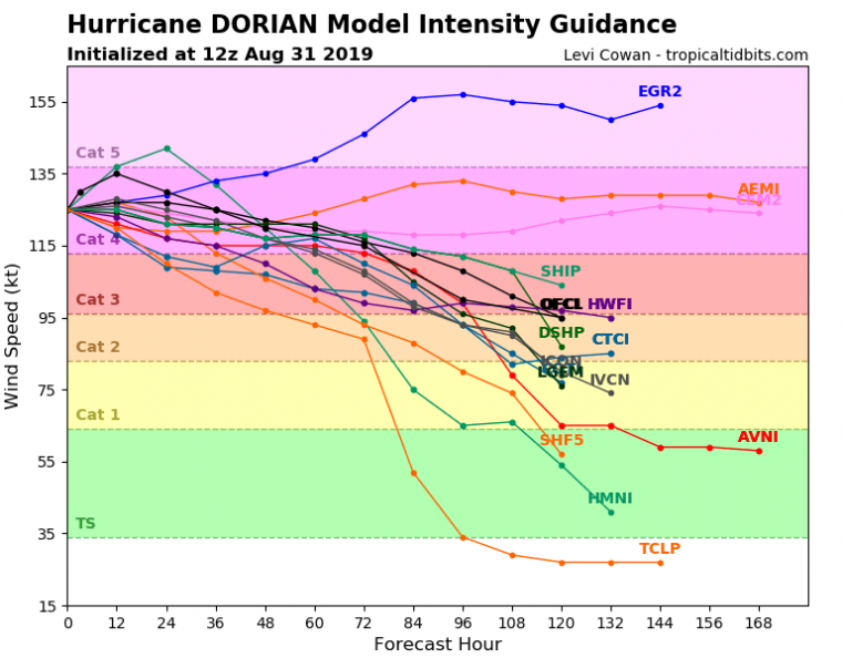
Intensity model guidance for Dorian. Source: tropicaltidbits.com
Immediate-term impacts for the Bahamas are expected by the NHC to include severe to catastrophic wind damage for areas adjacent to the core, with more widespread impacts of lesser severity over a broader area. Storm surge and inland flooding due to heavy rainfall are also expected. Specifics can be found at www.nhc.noaa.gov.
For the longer term Dorian should expand in size, and impacts for coastal and interior areas remain probable from the Florida Peninsula to the Carolinas. This will include downed trees and powerlines with resulting power outages, with light to moderate wind impacts for affected structures. Impacts will be more severe for points where the core of the storm moves onshore or nearby. The increased size of the storm and reduced forward speed will also amplify the threat of storm surge at the ultimate point of landfall, and surge impacts can also be expected along coastal areas even if the storm remains offshore. Significant rainfall accumulations are also expected to produce the threat of flooding and flash-flooding in affected areas.
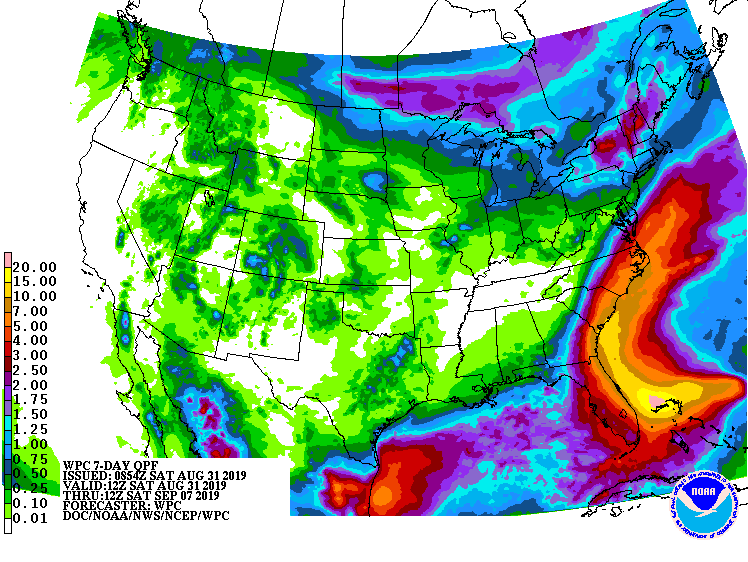
7-Day Rainfall Accumulations. Source: NOAA/WPC
The NHC and Local Offices maintain watches and warnings for areas under potential or immediate threat. Specifics can be found at www.nhc.noaa.gov, www.weather.gov, and official government agencies. Official watches and warnings, and statements from emergency management agencies supersede this update, and should be closely followed concerning matters of personal safety.
Next Update
The next Weather Sentinel update will be issued on Sunday, September 1. For up to date, official information, the following websites are recommended:
National Weather Service, Melbourne, FL
National Weather Service, Jacksonville, FL
National Weather Service, Charleston, SC
National Weather Service, Newport/Morehead City, NC
South Carolina Emergency Management
North Carolina Emergency Management
Subscribe to Guy Carpenter Email Alerts on Real Time Activity
To receive email notifications of Weather Sentinel updates, please click on this link to update your preferences.
https://go.guycarp.com/preferencecenter
Additionally, in response to client demand, we are pleased to offer daily email alerts for any tropical cyclone occurring globally. The GC Global Tropical Cyclone Alert discusses active tropical cyclones across the globe, portraying a graphical forecast and brief commentary on intensity forecast changes expected over a 24 hour period. Fill out the form at the link below to start receiving our key insights.