

Weather models are raising confidence and concern that Hurricane Dorian will make an eastern Florida landfall as a major hurricane, between late Sunday and early Tuesday of the 2019 Labor Day weekend. Several critical aspects of the forecast that are being analyzed to gain further confidence in Dorian's track and potential impact to Florida are discussed below. Additionally, a discussion of historical analogs to Dorian is examined as well as other implications of the forecast, regardless of ultimate landfall.
Status (11AM EDT Advisory, 29 August)
Dorian intensified to category-1 status crossing the Virgin Islands yesterday afternoon, according to the National Hurricane Center (NHC). Currently, hurricane force winds extend 15 miles and tropical storm force winds extend 90 miles from center. Dorian is moving northwest at 13 mph, located 425 miles east-southeast of the southeastern Bahamas. While Dorian is maintaining category-1 strength at the current time, intensification is expected to escalate tomorrow and continue into the weekend. The NHC intensity forecast calls for a low end category-4 landfall on the central Florida coast late this weekend, with the cone of uncertainty encompassing the entire Georgia and Florida coastline.
Progression of NHC Advisories as Dorian approached and moved through the Windward and Leeward Islands. Source: NHC
Category 1 Hurricane Dorian Status – 11AM EDT (09 UTC) (NHC)
- Location: 370 miles east-southeast of the southeastern Bahamas
- Maximum sustained winds: 85 mph
- Motion: northwest at 13 mph
- Minimum central pressure: 986 mb
- Extent of hurricane force winds from center: 15 miles
- Status: category 1 today, strengthening expected into weekend
Puerto Rico/Virgin Islands Overview
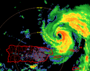
Dorian tracked across the Virgin Islands yesterday afternoon. The strongest wind report occurred on Buck Island in the USVI, with sustained winds of 82 mph, gusting to 110 mph. The weather station on Buck Island is elevated 90 feet, higher than standard weather stations at 33 feet. Most of Puerto Rico was spared by Dorian as the highest winds in measured at San Juan were 29 mph, gusting to 34 mph.
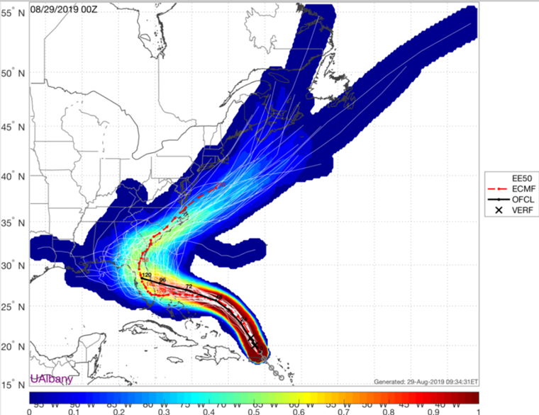
Over the past 48 hours, Dorian has verified consistently north and east of even 24 and 48 hour forecasts, as illustrated in the graphic below. Therefore, Dorian missed the mountainous regions of Hispaniola and Puerto Rico, emerging as a stronger storm in the southwestern Atlantic.
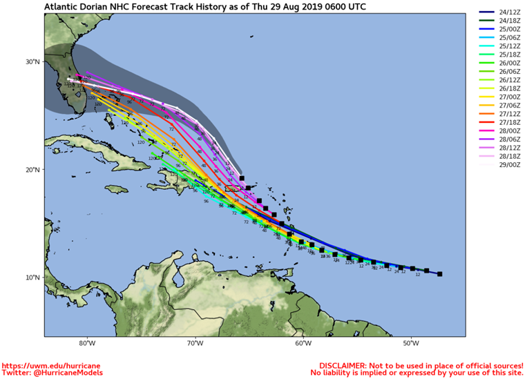
Forecast track verification of National Hurricane Center forecasts for Dorian, with a notable south and west forecast bias, with recent verification further north and east than anticipated. Source: Dr. Clark Evans, University of Wisconsin-Milwaukee
Implications of recent weather model bias for possible landfall scenarios
- Scenario 1 - southern Florida landfall: The recent verification of Dorian north and east of expectations raises interesting longer term implications. Weather models that are verifying further north and east over the last 48 hours are more likely to turn Dorian more prominently to the west this weekend. These tracks ultimately make landfall in the southern half of the Florida Atlantic Coast, taking longer to reach the coastline on Monday night or Tuesday morning. These models have more time for the storm to develop over exceptionally deep and warm waters (ocean heat content) of the Bahamas. Additionally, these scenarios project Dorian making landfall above the NHC current mean intensity projection, as a stronger category-3 or 4 hurricane.
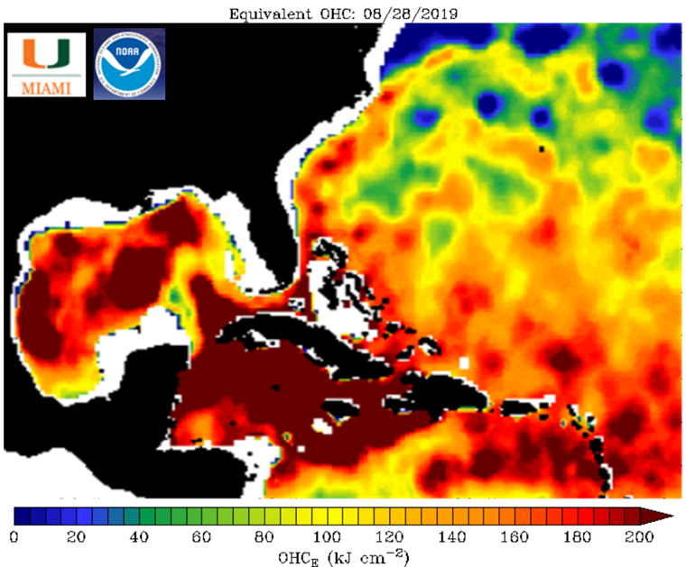
Ocean heat content for the Caribbean, Gulf of Mexico and southwestern Atlantic. Deeper, warmer water, more capable of sustaining major hurricanes, lies along the Bahamas. Ocean heat content is relatively lower off the northern Florida coastline. Source: NOAA/NOS/UMiami
- Scenario 2 - central/northern Florida landfall: Conversely, weather models projecting a track further west in the next 48 hours ultimately make landfall in the central or northern Florida Atlantic Coast, reaching the coastline by late Sunday or early Monday. Tracks projecting this scenario are faster to the coast, maintaining a west-northwest track to landfall. Also, the propensity for Dorian to slow down before crossing land is lower, resulting in less time over water before landfall. Tracks forecasted further north do not spend as long of time over exceptionally high ocean heat content, and are more in line with NHC current median expectation of a category 3 landfall.
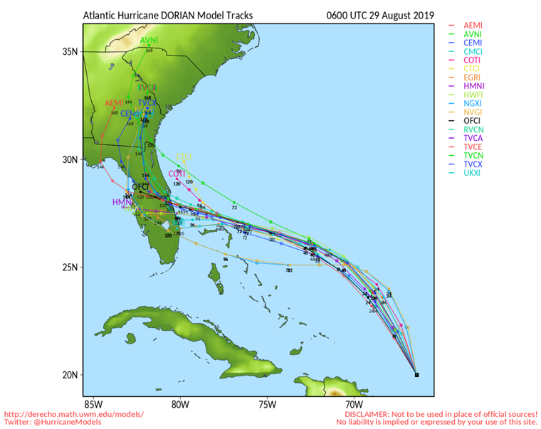
Major weather models projecting Dorian's approach to the Florida coast. Most model guidance has shifted south in the past 36 hours, with southern outliers yesterday being the model consensus today. Source: Dr. Clark Evans, Univ. Wisconsin Milwaukee
What comes next to raise confidence in Dorian's ultimate track?
The fact that recent verification of Dorian departing the Caribbean further north than consensus is noteworthy. Ironically, tracks further north in the short term increase the prospects of an ultimate landfall further south along the Florida peninsula. These tracks are modeling with higher landfall intensities than the NHC current forecast. Additionally, model guidance consensus is also shifting south over the last 24 hours. Tracks further south into Florida raise implications longer term into next week. After Florida, Dorian could either track into the Gulf of Mexico, or stall over/near Florida and move slowly northward next week. Weather model guidance over the coming 12-24 hours will be closely scrutinized for further trends to augment confidence in the forecast.
European weather model 51 member ensemble project for Dorian. The operational model of the European (dashed red line) is south of the ensemble consensus, illustrated in the warmest shaded colors. The European ensemble consensus is south of NHC's 5AM EDT forecast. Source: Dr. Brian Tang / UAlbany
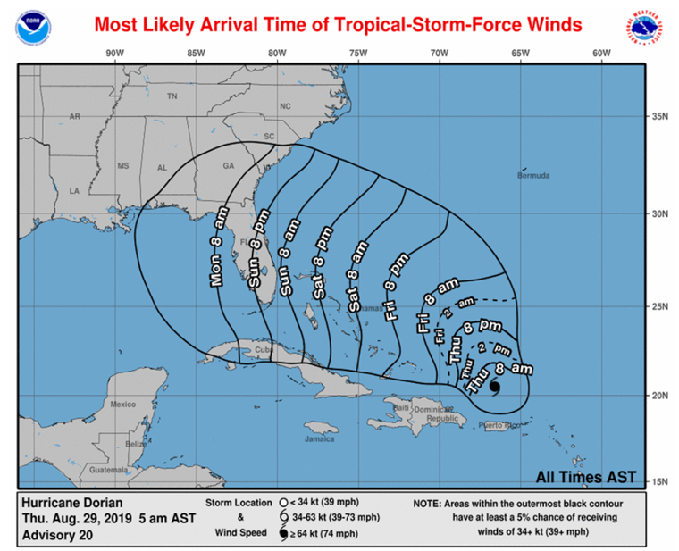
Most likely onset of tropical storm force winds in excess of 39 mph. Given the projected increasing size of Dorian before landfall, tropical storm force winds could occur 12-24 hours before sustained hurricane winds. Source: NHC
Placing the Dorian forecast in historical context
This is a moment where historical analogs serve a useful purpose to see what has happened in a similar manner dating back to the mid-1800s. Only seven major hurricanes (category-3 or stronger on the Saffir-Simpson scale) have made landfall heading due west or west-northwest into the east coast of Florida, identified in the map below. The historical tracks highlight the high level of sensitivity of landfall location to industry insured loss outcomes. Several of these events rank in the most damaging of all landfalling U.S. hurricanes, adjusted for current day exposure and inflation: the Great Miami 1926 hurricane, the 1928 Okeechobee hurricane, and 1992 Andrew. Granted, these three hurricanes made landfall as a strong category-4 or 5, which is currently stronger than intensity consensus from the NHC as well as the majority of weather models. On the other side of the spectrum, a repeat of Hurricane Dora in 1964 would generate an industry loss lower than any of the major 2017/18 landfalling hurricanes. Jeanne and the Unnamed August 1871 landfalls would produce insured losses in the range of the events impacting Florida in the last two years.
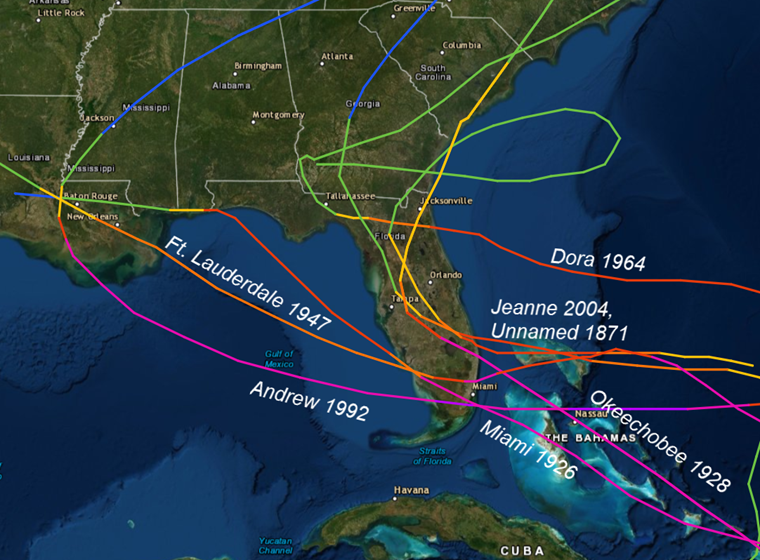
Best fit historical analog hurricanes that approach Florida from the east at major category three or higher landfall intensity. Source: NOAA
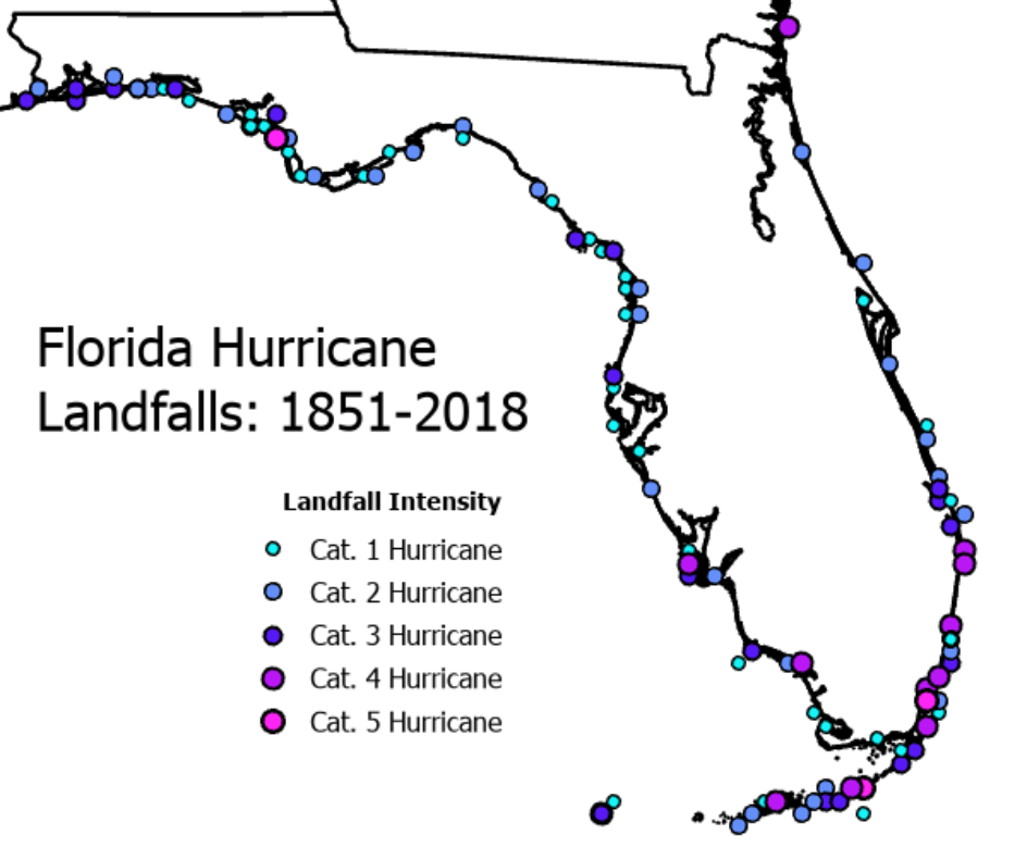
Landfalling hurricane locations, colored coded by Saffir-Simpson scale intensity, for the state of Florida from 1851-2018. Source: Dr. Phil Klotzbach, Colorado State University
King Tide to Further Amplify Dorian Storm Surge
With any major landfalling hurricane, storm surge is a major concern for coastal damage. Dorian's storm surge will be amplified by higher than average high tides, transpiring this weekend. Due to the lunar cycle and the new moon, tides will be higher than average, producing the "King Tide". Dorian's potential Florida landfall will coincide with the highest high tide levels of the next 30 days. On Virginia Key in Biscayne Bay, King Tides result in sea levels nearly eight inches higher than average. King Tide is increasingly associated with 'nuisance coastal flood events' in which low-lying areas of Miami see coastal flooding, even on clear and sunny days. The chart below highlights how much the tidal cycle in south Florida is influenced by the lunar cycle and King Tide, which peak on Sunday of this weekend. Swells and increased high tides are anticipated as far north as the Carolinas due to Dorian's approach and the King Tide.
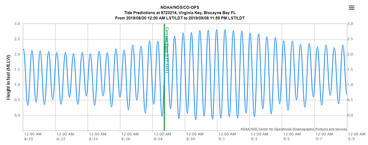
30-day time series of tide cycles at Virginia Key, Biscayne Bay, FL, highlighting the lunar influence on higher high tides this coming weekend, called the King Tide. Source: NOAA/NOS
Next Update
The next Weather Sentinel update will be issued on Friday, August 30. For up to date, official information, the following websites are recommended:
National Weather Service, Miami, FL
National Weather Service, Melbourne, FL
Official watches and warnings, and statements from emergency management agencies supersede this update, and should be closely followed concerning matters of personal safety.
Subscribe to Guy Carpenter Email Alerts on Real Time Activity
To receive email notifications of Weather Sentinel updates, please click on this link to update your preferences.
https://go.guycarp.com/preferencecenter
Additionally, in response to client demand, we are pleased to offer daily email alerts for any tropical cyclone occurring globally. The GC Global Tropical Cyclone Alert discusses active tropical cyclones across the globe, portraying a graphical forecast and brief commentary on intensity forecast changes expected over a 24 hour period. Fill out the form at the link below to start receiving our key insights.