

Hurricane Dorian was a long-lived and historic storm that rendered impacts from the Caribbean to Atlantic Canada between August 24 and September 7, 2019.. It is evident from media reports that the most severe impacts occurred in the northwestern Bahamas where complete destruction of property and infrastructure was reported in Grand Bahama and Abaco Islands. The full scope and severity of impacts still has yet to clarify, but it is apparent that conditions on the Islands will be very difficult for some time. Our thoughts and concerns are with those directly affected by the event. Dorian slowly crossed the area as a category-5 hurricane with maximum sustained winds of up to 185 mph, the strongest hurricane to cross the area in recorded history.
Dorian then followed the Southeast Coast of the United States to make landfall on Cape Hatteras, North Carolina as a category-1 hurricane. The storm brought downed trees and powerlines with some property damage due to wind, coastal flooding and beach erosion, along with considerable tornado activity in the eastern Carolinas. Dorian finally crossed Atlantic Canada as a post-tropical cyclone with equivalent category-2 strength to render downed trees and powerlines with some property damage, while also rendering tropical storm conditions in portions of New England.
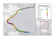
Hurricane Dorian Track and Position Reports. SOURCE: National Hurricane Center.
Physical Discussion
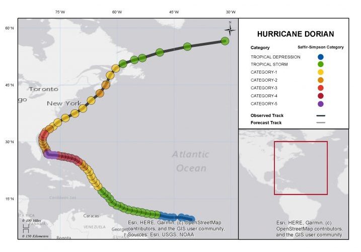
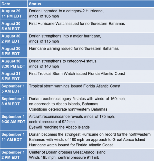
According to statements of the U.S. National Hurricane Center (NHC), Dorian originated on Saturday, August 24 as a tropical depression roughly 800 miles east-southeast of Barbados in the Atlantic Ocean. The storm was upgraded to tropical storm strength the same day making Dorian the fourth tropical storm of the 2019 Atlantic hurricane season. Tropical Storm Dorian followed a track to the west-northwest for the next few days while maintaining tropical storm intensity, as it passed Barbados and the Windward Islands before moving into the eastern Caribbean Sea. Dorian then took a more northwesterly track through the eastern Caribbean Sea to approach Puerto Rico from the southeastern side of the island, all the while gradually strengthening.
Dorian key events. Source: NHC.
Dorian was classified as a hurricane by the NHC on Wednesday, August 28 as it was located near St. Thomas in the U.S. Virgin Islands. Moderate strengthening occurred while it continued to move northwest over the open Atlantic. On August 29, Dorian gained strength as a category-2 hurricane, followed by a period of rapid intensification as it moved through an environment with anomalously warm waters and reduced wind shear. During the evening of August 30, aircraft reconnaissance revealed that the storm carried maximum sustained winds of 140 mph, a category-4, after which time the storm began a reduction in forward speed. Dorian gained further strength to reach status as a category-5 hurricane as it approached the northwestern Bahamas on the morning of September 1.
Just a short time later, data from aircraft reconnaissance indicated that Dorian had gained strength to carry maximum sustained winds of 175 mph, in an environment with high ocean heat content (warm waters of depth) and reduced wind shear. Just as the storm was crossing Great Abaco Island, Dorian gained peak strength with maximum sustained winds of 185 mph, tying as the second strongest hurricane in known history for the Atlantic Basin, and among only a handful of known storms in the Atlantic Basin to reach 1-minute sustained winds of 185 mph or more. Dorian is also the strongest hurricane in recorded history for the northwestern Bahamas. Dorian acquired a minimum central pressure of 910 mb while crossing the area.
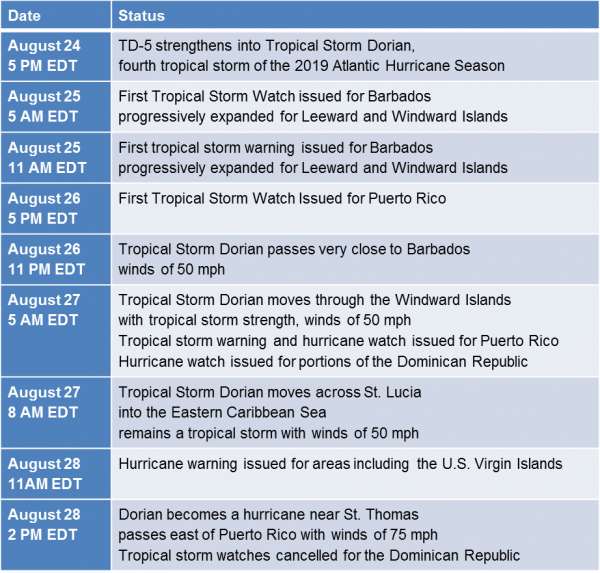
Satellite loop of Hurricane Dorian during passage of Abaco Island (Visible), September 1, ending 19:41 UTC. Source: NOAA/NESDIS.
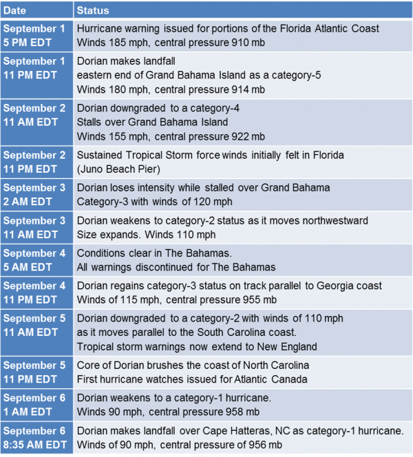
As steering currents collapsed between two adjacent weather systems, Dorian then stalled over Grand Bahama Island for more than a full day after moving ashore late on September 1, while maintaining category-5 strength for nearly 12 hours. Dorian weakened slightly on September 2. As a result of prolonged exposure to winds of a significant hurricane and storm surge, severe to complete damage was rendered to both property and infrastructure across Abaco and Grand Bahama Islands.
Dorian key events. Source: NHC.

Hurricane Dorian Track and Position Reports. SOURCE: NHC.
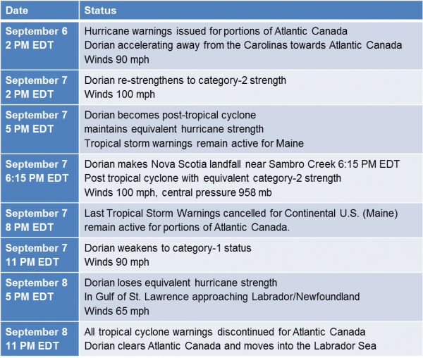
As a weakness developed in the subtropical ridge, Dorian finally began moving to the northwest and away from Grand Bahama on Tuesday, September 3. Dorian weakened to a category-2 hurricane in the meantime. The storm maintained this strength over the next day and a half as it approached and then moved parallel to the Florida and Georgia coastline. At 11 PM EDT on September 4, Dorian regained strength as a category-3 hurricane with maximum sustained winds of 115 mph, once again gaining major hurricane strength. Dorian then moved within roughly 50 miles of the South Carolina coast on September 5, and again weakened to a category-2 hurricane during the period. Dorian weakened further to a category-1 hurricane with maximum sustained winds of 90 mph as of 2 AM EDT September 6, before the western eyewall began to brush the northern portion of the North Carolina coast that same morning.
According to the NHC, Dorian made landfall at 8:35 EDT (12:35 UTC) on September 6 in Cape Hatteras, North Carolina. Maximum sustained winds at landfall were 90 mph, a category-1 hurricane. Dorian is the first hurricane to make landfall since Hurricane Florence (2018) in North Carolina, although the faster forward speed of Dorian greatly reduced the degree of inland flooding due to heavy rainfall. A report of 77 mph sustained winds was reported by a local weather station at Hatteras High School, and storm surge unofficially reached 6 feet at Hatteras Island. While moving along and brushing the coast of the Carolinas, feeder bands produced considerable tornado activity over northeastern South Carolina and eastern North Carolina.
Dorian key events. Source: NHC.
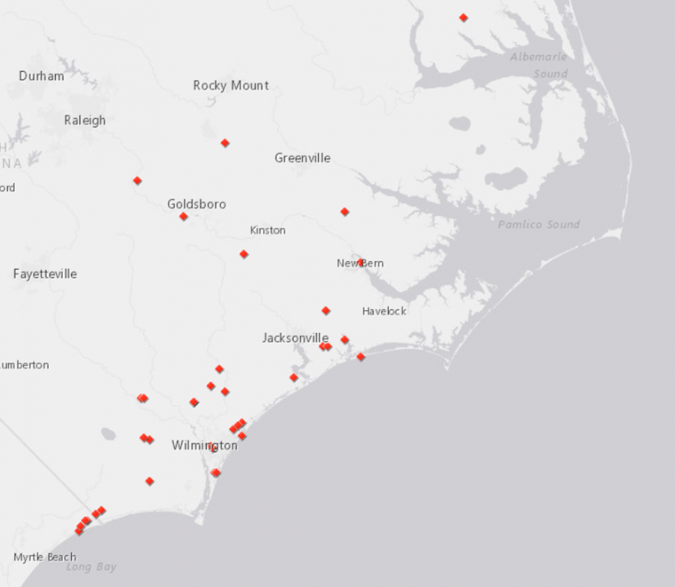
Tornado Local Storm Reports from Dorian. Source: NOAA/SPC.
Following landfall in North Carolina, Dorian moved offshore into the Atlantic and gained forward speed as it moved to the northeast. Despite being well offshore, Dorian’s large size brought tropical storm force winds to areas of southeastern Massachusetts on September 7. That same evening, Dorian was classified as a post-tropical cyclone as it moved over much cooler waters, bringing further expansion of the wind field and a more asymmetric structure. The storm also regained strength to carry maximum sustained winds of 100 mph. Dorian made another landfall over Nova Scotia near Sambro Creek at 6:15 PM EDT (22:15 UTC), with maximum sustained winds of 100 mph, an equivalent category-2 post-tropical cyclone. Dorian then weakened to an equivalent tropical storm with 65 mph winds, while crossing into the Gulf of Saint Lawrence and affecting Labrador and Newfoundland. Dorian then moved into the Labrador Sea.
Concerning storm surge impacts, observational data in regards to surge is still scarce in the Bahamas. However, initial model guidance indicates surge levels in excess of 15-20 feet above NAVD88 datum on the north facing shore of Grand Bahama and 8-12 feet on the west facing shore of Great Abaco, according to CERA. This extreme level of surge was generated in part by the long duration of wind exposure, a consequence of the stall in Dorian’s forward speed, and the shallow waters found to the north of Grand Bahama and west of Grand Abaco.
In the southeast United States, Dorian’s winds remained largely shore-parallel with the effect of mitigating surge levels along the coast. Surge levels reached a maximum of approximately 3.3 feet at Port Canaveral, Florida, 5.3 feet at Fernandina Beach, Florida, 5.5 feet at Fort Pulaski, Georgia, and 4.4 feet at Charleston, South Carolina (all surge levels are relative to NAVD88 datum). Further mitigating surge levels in the southeastern US was the fact that peak surge aligned closely with local tidal minima.
Dorian key events. Source: NHC.
Impacts
Hurricane Dorian has affected regions from the Caribbean to Atlantic Canada. It is evident from media reports that the most severe impacts occurred in the northwestern Bahamas where property and infrastructure were completely destroyed in areas including Grand Bahama and Abaco Islands. The full scope and severity of impacts continues to clarify as search, rescue and recovery efforts continue. Meanwhile for the Continental United States and Atlantic Canada, reports of downed trees and powerlines were widespread along with variable property damage due to wind and flooding. Power outages were widespread, including about 400,000 homes and businesses in the Carolinas and Virginia.
Media reports indicate that estimated insured losses for the Caribbean will range from USD 1.5-3.0 billion, according to AIR Worldwide (accounting for storm surge, property, auto and time element, but excluding offshore properties and infrastructure). Other media reports reveal estimated “insured and uninsured” losses for the Bahamas on the order of USD 7 billion, including buildings and business interruption, as reported by Karen Clark & Co. Meanwhile reports indicate another estimate from RMS of Caribbean insured losses on the order of USD 3.5-6.5 billion (primarily Bahamas accounting for wind and storm surge, for property, business interruption and auto as well as loss-amplification). Loss estimates will continue to evolve over the coming days and weeks as the full scope and severity of impacts continues to clarify.
The Bahamas
Media reports indicate significant destruction to portions of the northwestern Bahamas, with complete destruction to affected property and infrastructure for much of the Grand Bahama and Abaco Islands. Significant damage to infrastructure was also reported.The most severely affected areas have been rendered uninhabitable as a result. According to media reports, Prime Minister Hubert Minnis is referring to the level of destruction in the Bahamas as “generational devastation”. At least 50 fatalities have been officially confirmed with many missing, and as recovery efforts continue the death toll could well grow into the thousands. More than 13,000 houses, or roughly 45 percent of the homes in Grand Bahama and Abaco were severely damaged or destroyed according to Red Cross estimates. Local authorities have indicated that this number could be much larger. The United Nations estimates at least 70,000 people are in immediate need of food, water, and shelter. Global support and relief efforts are currently being provided from numerous countries, including the United States, Jamaica, Trinidad and Tobago, the Netherlands, and Great Britain. Certain cruise lines are also providing transportation and food supplies or affected areas. The United Nations World Food Programme also indicated an airlift of logistical equipment for emergency responders along with eight metric tonnes of ready-to-eat meals to support the long-term relief effort.
Abaco Islands
Widespread devastation is evident from media reports, including damage to homes, shops, the harbor, a hospital and airport landing strips. The Bahamas Ministry of Tourism and Aviation has reported that an estimated 80 percent of the population of the Abaco Islands has been rendered homeless as a result of the storm. Media reports also indicate that most structures in the areas of Elbow Cay, Man-o-War, and Marsh Harbor have been damaged, destroyed, or submerged by storm surge. An estimated 90 percent of infrastructure in Marsh Harbor has been damaged or destroyed.
Grand Bahama
A substantial portion of the northern coastline was completely inundated by seawater as a result of storm surge. An estimated 60 percent of Grand Bahama Island was underwater following Dorian’s landfall, according to Iceye SAR Satellite Constellation. Significant damage with seawater flooding was observed at the Grand Bahama Airport near Freeport, considerably hindering relief efforts and evacuations on the island. Reports indicate that the airport runway was repaired on Saturday and was ready for flights. Widespread wind and surge damage has also been reported throughout accessible areas of Freeport. In the community of High Rock, every home has been damaged or destroyed, according to media reports.
Florida
At least three fatalities have been reported by media, due to storm preparation or cleanup. Major beach erosion was reported by media on Flagler Beach and Vero Beach, and some damage to homes was reported on Hutchinson Island due to the combined effects of storm surge and wave battering. Streets and parking lots also flooded during high tide on barrier islands near Fort Pierce. Meanwhile, the storm caused some flooding for portions of Saint Augustine and flood-prone areas of Jacksonville. Inundation was also reported for some homes on Anastasia Island north of Saint Augustine Beach. Reports indicate that the seawall at Palm Coast was overtopped by seawater by three inches. Some beach erosion was also reported in the Space Coast area. Mandatory evacuations were issued for immediate coastal areas but since rescinded after the threat cleared. Ports have reopened and cruise ships have returned to schedule.
Georgia
Emergency officials reported relatively light damage along the Georgia coast. Evacuation orders were issued for coastal areas under threat. However, these were lifted Thursday morning as the threat cleared. Power outages affected at least 12,000 customers.
South Carolina
The combined effects of storm surge and heavy rainfall caused some flooding in Charleston, with closure necessary for dozens of streets. The timing of the peak storm surge came with lower tides, lessening the general severity of coastal flooding in Charleston. Downed trees and powerlines were reported in the state, including along the I-95 and I-26 corridors. A tree fell on a home in the West Ashley neighborhood of Charleston causing one injury, according to media reports. In the meantime tornado activity was reported by the U.S. Storm Prediction Center in Horry County, with roof and siding damage reported in Little River. A tornado was also reported near North Myrtle Beach.
North Carolina
At least one fatality has been reported by media. Significant damage was reported by media on Ocracoke Island. Emergency officials deployed fuel, generators, food and water to affected areas in Ocracoke. At least 200 people were in shelters according to officials. Evacuation orders were issued for areas in Hyde County under significant threat, and these were lifted on Sunday. Road closures due to flooding were reported along multiple stretches of I-40 near the Sampson-Duplin line north of Turkey. Fifteen roads were also closed in Sampson County due to flooding, with one section of road washed out near Clinton. Meanwhile the U.S. Storm Prediction Center (SPC) reported considerable tornado activity in eastern North Carolina, causing downed trees and powerlines with variable property damage. This includes an EF-2 tornado reported near Carolina Shores.
Virginia
Flooding was reported in areas of southeast Virginia during the storm’s passage, including Norfolk and Sandbridge.
New England
Tropical storm conditions were reported for areas of southeastern Massachusetts. Downed trees and powerlines were reported along with resulting power outages in several locations across Cape Cod. Meanwhile several homes and businesses lost power for affected areas in Maine.
Atlantic Canada
Media reports indicate downed trees and powerlines with widespread property damage in affected areas. In the City of Halifax, media reports again indicate widespread property damage including roofs ripped off apartment buildings and a construction crane that was brought down. Downed trees and powerlines were also reported. Power outages affected over 400,000 customers in Nova Scotia, affecting about 80 percent of customers. Area roadways were blocked with trees and debris from the storm causing transportation disruption. Schools were closed Monday in Nova Scotia on account of the storm. Meanwhile in Prince Edward Island, power outages affected about 75 percent of homes and businesses, with about 80,000 also affected in New Brunswick. Canadian Armed Forces personnel were deployed to support recovery and rescue efforts in Atlantic Canada.
Sources: U.S. National Hurricane Center, U.S. National Weather Service, U.S. Storm Prediction Center, Colorado State University Tropical Meteorology Project, Reuters, Associated Press, BBC, The Weather Channel, CBC, AIR Worldwide, Karen Clark & Co, RMS, CERA.