

Several tropical storms or hurricanes have developed in recent days to pose a potential threat to property, affecting locations in Bermuda, Mexico and the northwestern Gulf. Hurricane Humberto is expected by the National Hurricane Center (NHC) to make close approach to Bermuda, with the threat of tropical storm and potentially hurricane conditions. In the meantime Tropical Storm Lorena should pass near or over the Pacific Coast of Mexico as a hurricane, for the threat of hurricane wind conditions and heavy rainfall. Tropical Storm Imelda crossed the northeast Texas coast yesterday and still carries the threat of heavy rainfall and flooding. Later this week and into the weekend, the Leeward Islands, Virgin Islands and Puerto Rico also may come under threat from Tropical Storm Jerry as it develops into a hurricane. Several other tropical features are being monitored by the NHC for potential development as we clear the climatological peak of hurricane season.
Further updates below follow recent guidance from the NHC.
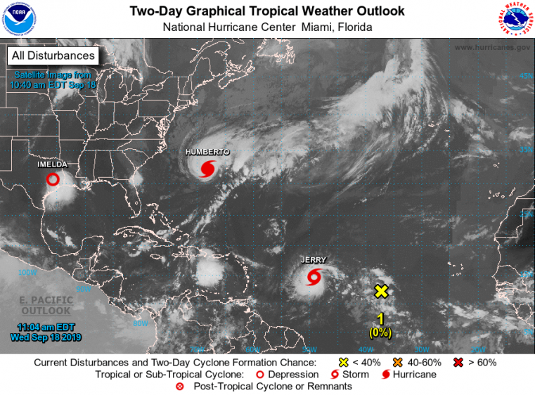
Tropical weather outlook - Atlantic Basin. Source: NOAA/NHC.
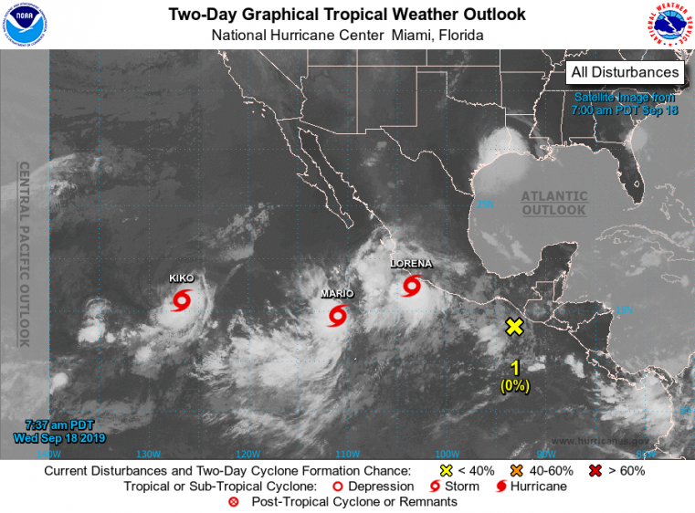
Tropical weather outlook - East Pacific Basin. Source: NOAA/NHC.
Hurricane Humberto
Hurricane Humberto poses an imminent threat to Bermuda, to render tropical storm and potentially hurricane conditions over the coming hours.
Status (2 PM EDT/18 UTC NHC Advisory)
- Location: About 140 miles west of Bermuda
- Maximum sustained winds: 120 mph
- Motion: east-northeast at 16 mph
- Minimum central pressure: 952 mb
- Extent of hurricane-force winds: 105 miles
- Extent of tropical-storm-force winds: 195 miles
- Status: category-3 hurricane

Satellite loop of Hurricane Humberto on approach to Bermuda. Ending 1610 UTC. Source: NOAA/NESDIS
Humberto has continued to gain strength in recent days since crossing portions of the Bahamas as a tropical storm. The storm is now a major hurricane with maximum sustained winds of 120 mph. In the meantime Humberto has expanded in size, with hurricane and tropical-storm-force winds extending outward from the center to 105 and 195 miles, respectively.
The hurricane is on a track to the east-northeast, and this motion should take the core of the storm on close approach to the northwest and north of the island tonight. Model guidance is in close agreement on the scenario. Humberto should retain strength as a major hurricane in the meantime.
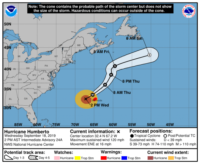
Position and 3-day best track forecast. Source: NOAA/NHC.
Conditions will continue to deteriorate on the island over the coming hours with tropical storm conditions developing and lasting through tomorrow morning. Hurricane conditions are also very possible tonight and into Thursday morning, especially for higher elevations. Tropical storm and hurricane warnings are both active for the island per the NHC. Hazards of concern include tropical storm to hurricane-force winds to render downed trees and powerlines with power outages and some property damage. A storm surge of 1-3 feet is also expected along with heavy rainfall amounts of 2-4 inches. Hazards and resulting impacts may escalate if Humberto makes a slight shift in track to the south, although the expected track should keep the worst conditions offshore.
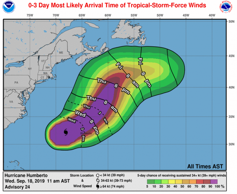
Most likely arrival time of tropical-storm-force winds and probabilities. Source: NOAA/NHC.
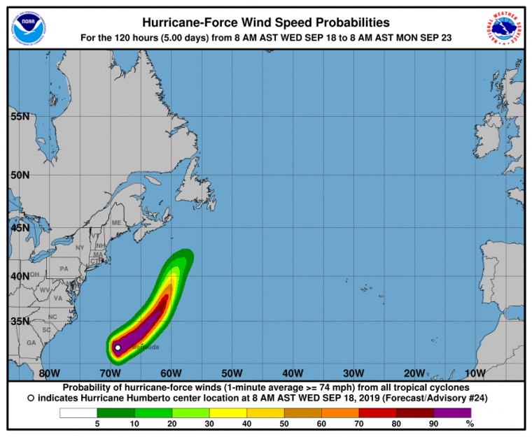
Probability of hurricane-force winds. Source: NOAA/NHC.
Tropical Storm Lorena
Tropical Storm Lorena poses an escalating threat for hurricane conditions and potential landfall on the Pacific Coast of Mexico.
Status (2 PM EDT/18 UTC NHC Advisory)
- Location: About 100 miles south-southeast of Manzanillo, Mexico
- Maximum sustained winds: 70 mph
- Motion: northwest at 13 mph
- Minimum central pressure: 993 mb
- Extent of tropical-storm-force winds: 90 miles
- Status: strong tropical storm, strengthening
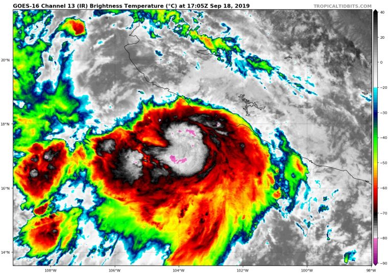
Satellite image of Tropical Storm Lorena on approach to Mexico (infrared). 1705 UTC. Source: tropicaltidbits.com.
Lorena developed from a disturbance south of Mexico. After clear evidence of a developing surface circulation and escalating thunderstorm activity, the feature was classified by the NHC as a tropical storm at 11 AM EDT (15 UTC) yesterday. The storm has since strengthened to carry maximum sustained winds of 70 mph with a central pressure of 993 mb. The storm is moving through an environment with very warm waters to support development, but tempered by moderate wind shear and increasing land interaction. The NHC is expecting development into a hurricane by this evening.
Lorena is expected by the NHC to follow a track to the northwest along the southwestern edge of a mid-level atmospheric ridge. The exact placement of the edge of the ridge will determine the ultimate track of the storm, with some uncertainty on timing and specifics as reflected in model guidance. Recent guidance has suggested a track further east than recent cycles. Accounting for the factors in play and evolving model guidance, the NHC best forecast takes Lorena on very close approach to the coast of southwestern Mexico through tomorrow morning, and landfall is very possible.
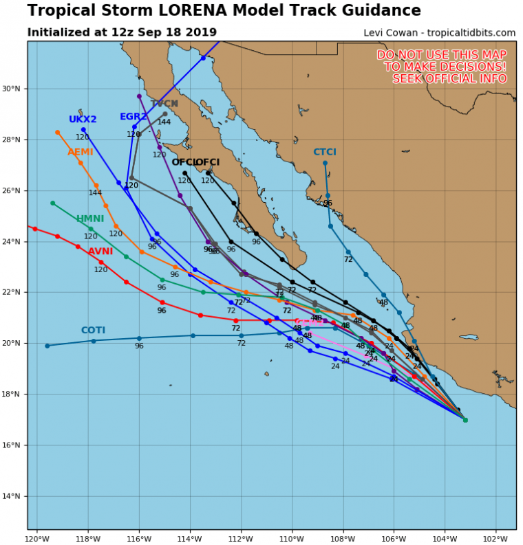
Model track guidance. Source: tropicaltidbits.com.
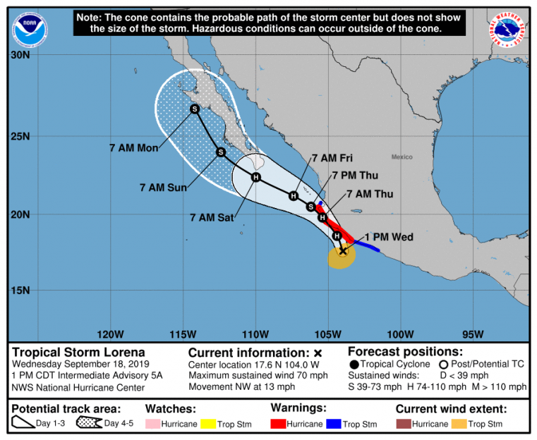
Position and best track forecast. Source: NOAA/NHC.
Regardless of exact track, hurricane conditions are likely, and a hurricane warning has been issued by the NHC for areas under immediate threat from Cabo Corrientes to Punta Mita. Hazards of concern include imminent onset of tropical storm to hurricane conditions, to render downed trees and powerlines with power outages and some property damage. Heavy rainfall amounts of 5-10 inches with local amounts to 15 inches are also possible to bring the threat of flooding and flash-flooding or inland areas.
Lorena should continue on a general track to the north and west through the weekend, to pose a threat for the Baja California Peninsula.
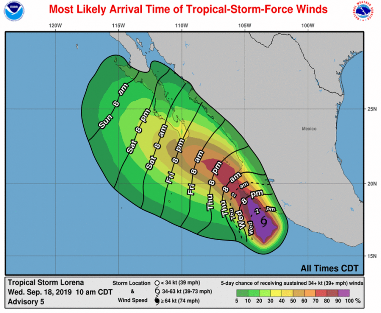
Most likely arrival time of tropical-storm-force winds and probabilities. Source: NOAA/NHC.
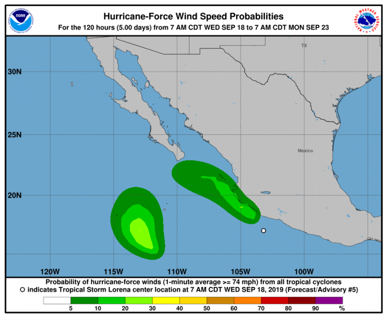
Probability of hurricane-force winds. Source: NOAA/NHC.
Tropical Storm Imelda
According to NHC advisories, Tropical Storm Imelda made landfall yesterday at about 2 PM EDT (18 UTC) at Freeport, Texas. Imelda was a minimal tropical storm at the time of landfall with maximum sustained winds of only 40 mph and a central pressure of 1005 mb. Imelda originated from an upper-level disturbance and associated thunderstorm activity over the warm waters of the northern Gulf of Mexico. The thunderstorm activity was able to consolidate in the days prior to landfall with clear evidence of a developing area of low pressure. As thunderstorm activity showed clear signs of escalation and organization yesterday, the feature was reclassified by the NHC as a tropical depression at 1 PM EDT (17 UTC) just before gaining strength as a tropical storm.
Landfall Status (2 PM EDT/18 UTC Tuesday September 17)
- Location: Freeport, Texas
- Maximum sustained winds: 40 mph
- Motion: north at 7 mph
- Minimum central pressure: 1005 mb
- Status: tropical storm
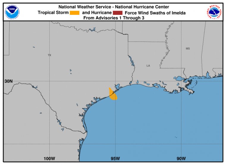
Tropical Storm Imelda wind history. Source: NOAA/NHC.
Imelda weakened after landfall and was downgraded by the NHC to tropical depression status at 8 PM EDT last night (00 UTC September 18), at which time all tropical storm warnings were cancelled. Imelda now retains status as a tropical depression, and it still poses a threat for heavy rainfall for areas of southeast Texas and Louisiana. . Rainfall amounts of up to 6-12 inches and isolated amounts to 18 inches are possible per the NHC, with heaviest amounts for near-coastal areas including the Houston and Galveston areas. Significant flooding and flash-flooding is probable, and the U.S. National Weather Service maintains watches and warnings for areas under threat. Current Status (11 AM EDT/15 UTC WPC Advisory)
- Location: About 65 miles north of Houston, Texas
- Maximum sustained winds: 30 mph
- Motion: north at 5 mph
- Minimum central pressure: 1009 mb
- Status: Tropical Depression
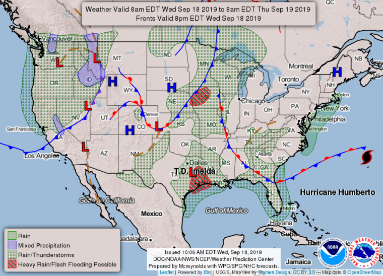
Surface analysis 8 AM (12 UTC) September 18. Note position of Imelda and flash-flood threat over northwestern Gulf states. Source: NOAA/WPC.
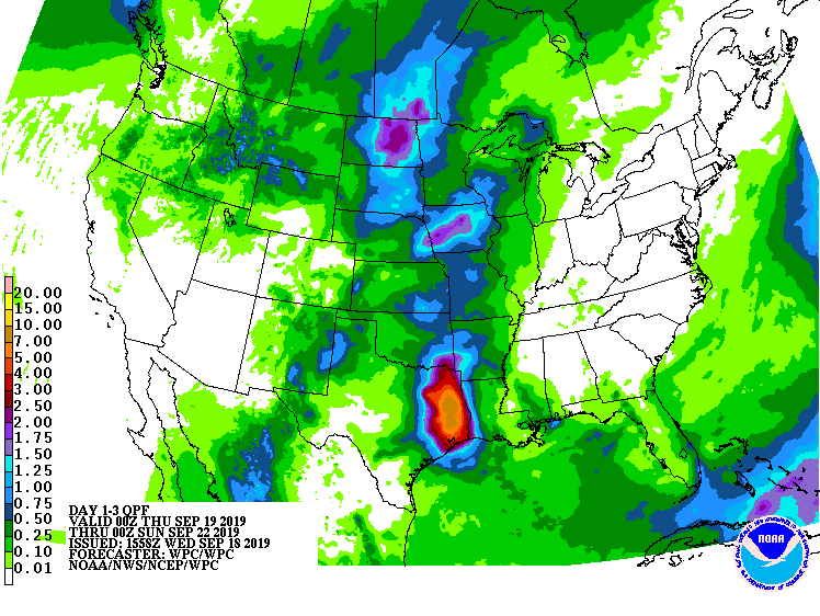
72-Hour precipitation forecast. Source: NOAA/WPC.
Tropical Storm Jerry
Current Status (11 AM EDT/15 UTC NHC Advisory)
- Location: About 855 miles east of the Leeward Islands
- Maximum sustained winds: 50 mph
- Motion: west-northwest at 14 mph
- Minimum central pressure: 1002 mb
- Extent of tropical-storm-force winds: 45 miles
- Status: tropical storm, strengthening
Tropical Storm Jerry originated from an African easterly wave (area of elongated low pressure clearing the African Coast) in recent days. The disturbance has produced shower and thunderstorm activity that has since been able to consolidate, organize and intensify while developing a clear area of low pressure with closed circulation. The feature was accordingly classified by the NHC as a tropical depression yesterday at 11 AM EDT (15 UTC), and gained status as a tropical storm twelve hours later.
As of this morning Jerry carries maximum sustained winds of 50 mph with a motion to the west-northwest at 14 mph, and this general motion is expected by the NHC to continue for the next day or so while strengthening into hurricane. This should take Jerry to the north of the Leeward Islands and Virgin Islands and then Puerto Rico through Saturday morning, with reasonable agreement in model guidance.
For the longer term, a turn to the north and then northeast is expected through a weakness in the subtropical ridge, and the timing and placement of this turn carries considerable uncertainty with a spread in model guidance. Accounting for these factors and underlying uncertainty, the NHC best track forecast takes Jerry to the north of the Virgin Islands and Puerto Rico through Saturday before a gradual turn to the north through Monday morning to the north and east of the Bahamas.
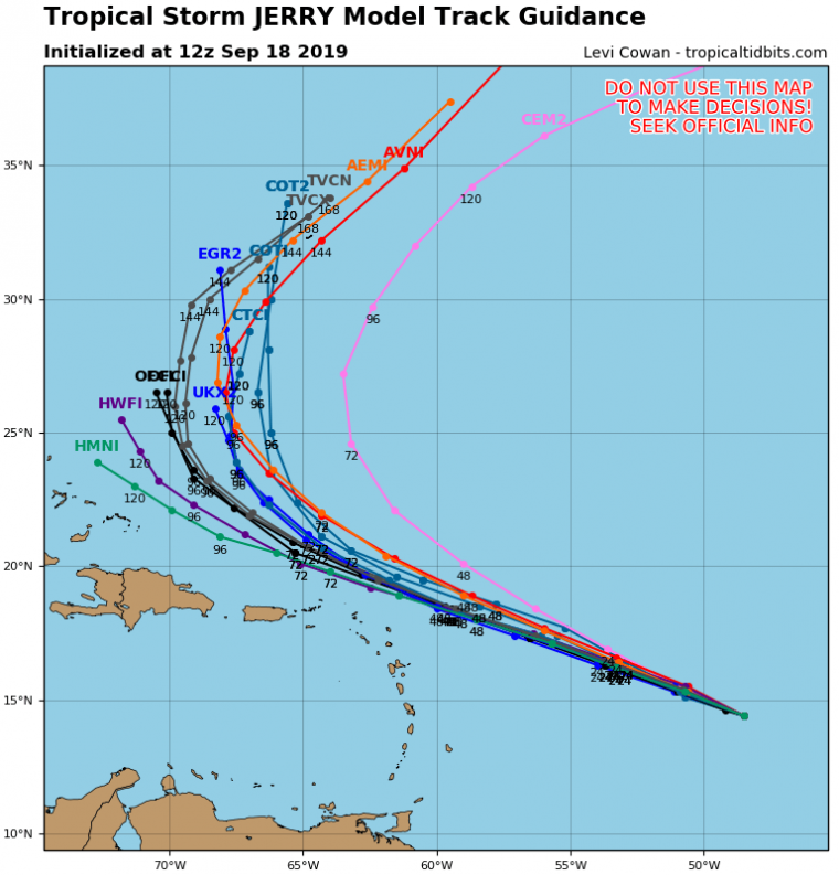
Model track guidance. Source: tropicaltidbits.com.
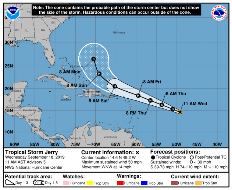
Position and best track forecast. Source: NOAA/NHC.
Any effects in the Leeward Islands, Virgin Islands, Puerto Rico or Hispaniola will closely depend on the track and size of the storm over the coming days. As it stands now tropical storm conditions are possible for Friday and into the weekend per the NHC, while hurricane conditions appear to be very unlikely. Tropical storm or even hurricane conditions may also be possible for portions of the Bahamas later in the weekend, and will depend closely on the exact track of the storm. The threat could escalate if the track were to shift further south, although this appears improbable given current model guidance.
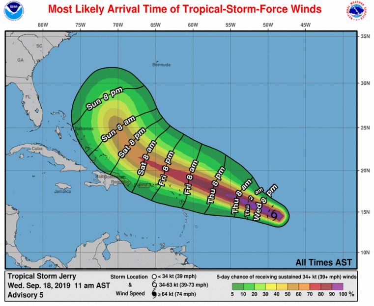
Most likely arrival time of tropical-storm-force winds and probabilities. Source: NOAA/NHC.
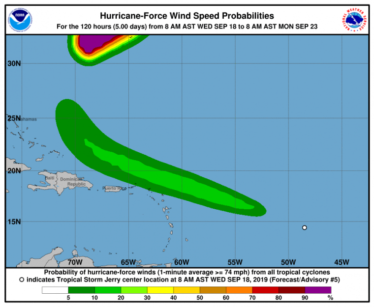
Probability of hurricane-force winds. Source: NOAA/NHC.
The NHC and other official agencies maintain watches and warnings for areas under potential or immediate threat. Specifics can be found at www.nhc.noaa.gov and www.weather.gov. Official watches and warnings, and statements from emergency management agencies supersede this update, and should be closely followed concerning matters of personal safety.
Further updates will be available on the CAT Resource Center of GC Capital Ideas as meaningfully new information comes available.
For up to date, official information the following websites are recommended:
Mexico National Weather Service
Subscribe to Guy Carpenter Email Alerts on Real Time Activity
To receive email notifications of Weather Sentinel updates, please click on this link to update your preferences.
https://go.guycarp.com/preferencecenter
Additionally, in response to client demand, we are pleased to offer daily email alerts for any tropical cyclone occurring globally. The GC Global Tropical Cyclone Alert discusses active tropical cyclones across the globe, portraying a graphical forecast and brief commentary on intensity forecast changes expected over a 24 hour period. Fill out the form at the link below to start receiving our key insights.