


Tropical activity continues for the North Atlantic and East Pacific Basins. A few features continue to pose an active threat for property. Tropical Storm Lorena is on a track very close to the Pacific Coast of Mexico, after bringing hurricane conditions and heavy rainfall. Meanwhile the remnants of Imelda continue to draw significant moisture onshore over the northwestern Gulf States to produce excessive rainfall and an escalating flood threat. Hurricane Humberto made close approach to Bermuda last night and brought hurricane conditions to the island, and has since cleared the island where conditions are improving. Further south, Tropical Storm Jerry should make close approach to the Leeward Islands and Virgin Islands as a hurricane tomorrow and Saturday before making a gradual turn to the north and northeast early next week.
Further updates follow below for selected storms, following advisories of the National Hurricane Center (NHC).
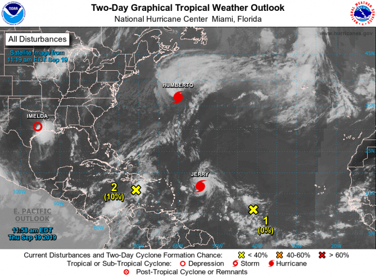
Tropical weather outlook - Atlantic Basin. Source: NOAA/NHC.
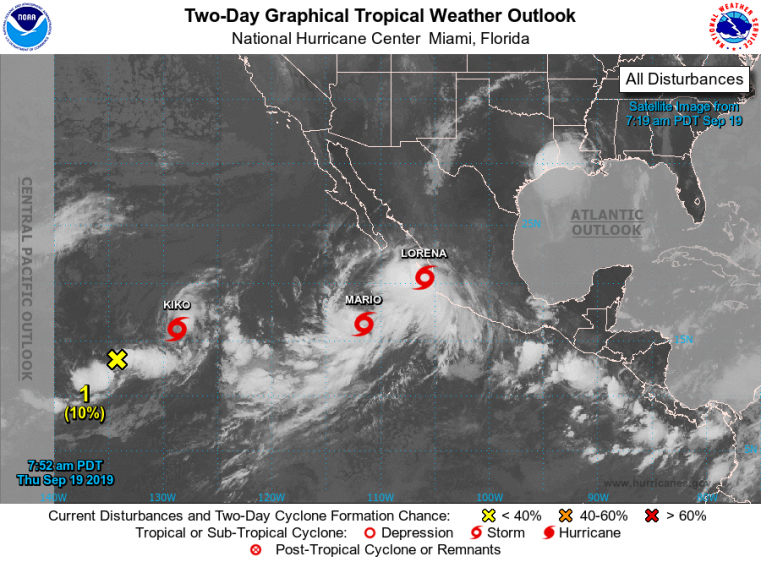
Tropical weather outlook - East Pacific Basin. Source: NOAA/NHC.
Tropical Storm Lorena
Tropical Storm Lorena made its approach to the Pacific Coast of Mexico yesterday afternoon. Lorena was then upgraded by the NHC to a hurricane at 11 PM EDT Wednesday (03 UTC Thursday) with maximum sustained winds of 75 mph, a few hours before the center of circulation passed within just 25 miles of Manzanillo, Mexico. Lorena continued to follow the coast of Mexico overnight and into this morning.
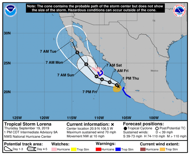
Status (2 PM EDT/18 UTC NHC Advisory)
- Location: About 60 miles northwest of Cabo Corrientes, Mexico
- Maximum sustained winds: 70 mph
- Motion: northwest at 10 mph
- Minimum central pressure: 994 mb
- Extent of tropical-storm-force winds: 80 miles
- Status: strong tropical storm

Satellite loop of Tropical Storm Lorena (infrared) ending 1705 UTC September 19. Source: tropicaltidbits.com.
Lorena is now moving away from the coast on a track to the northwest, following the edge of a nearby subtropical ridge. This general motion should continue with a turn to the west-northwest tonight due to interaction with nearby Tropical Storm Mario. The precise interaction and timing of these features is still uncertain, and model guidance still shows some spread, but clustering has improved in recent cycles. Accounting for these factors, the NHC best forecast takes Lorena further offshore this afternoon, to then pass near or just south of the southern coast of the Baja California Peninsula late Friday into Friday night.
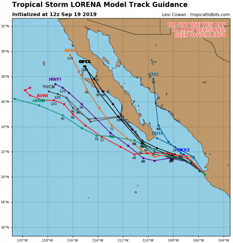
Model track guidance. Source: tropicaltidbits.com.
Position and best track forecast. Source: NOAA/NHC.
Concerning intensity, recent land interaction has caused Lorena to weaken back to a tropical storm. Warm waters and a favorable upper-level environment should allow Lorena to regain hurricane strength as it approaches the Baja California Peninsula per the NHC. Interaction with nearby Tropical Storm Mario may complicate the intensity forecast.
Tropical storm warnings remain active, and a hurricane watch is active for portions of the southern Baja California Peninsula. Hazards of concern include ongoing tropical storm conditions for warned areas of the Pacific Coast of Mexico, to bring downed trees and powerlines with power outages and some property damage. Heavy rainfall amounts of 5-10 inches with local amounts to 15 inches remain possible to bring the threat of flooding, flash-flooding and mudslides for affected areas. Lesser rainfall amounts are expected for portions of the Baja California Peninsula.
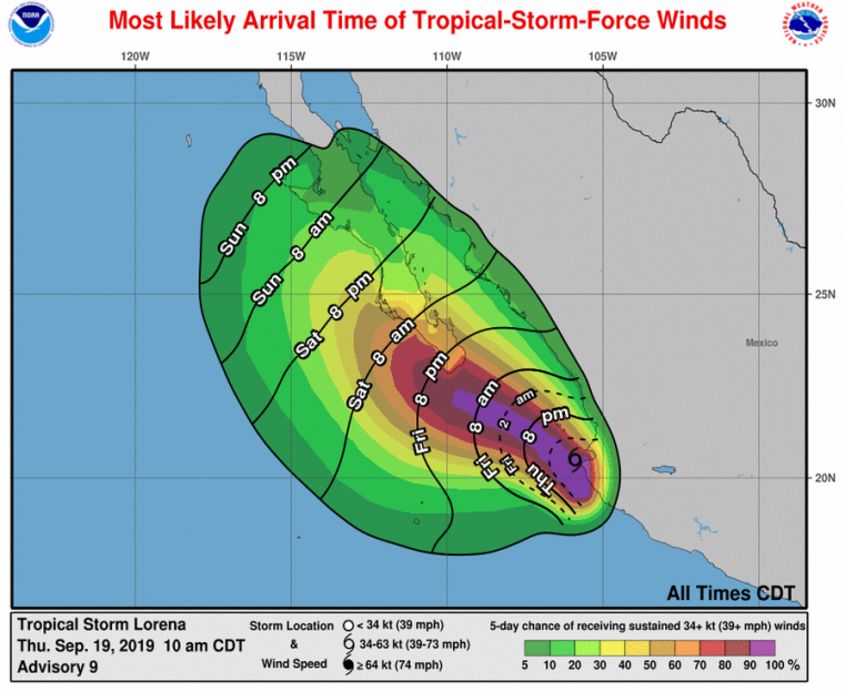
Most likely arrival time of tropical-storm-force winds and probabilities. Source: NHC.
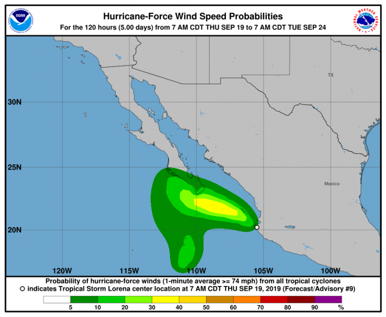
Probability of hurricane-force winds. Source: NHC.
Hurricane Humberto
Status (8 PM EDT September 18/00 UTC September 19 NHC Advisory)
- Location: About 75 miles north of Bermuda (closest approach)
- Maximum sustained winds: 120 mph
- Motion: east-northeast at 20 mph
- Minimum central pressure: 952 mb
- Extent of hurricane-force winds: 80 miles
- Extent of tropical-storm-force winds: 195 miles
- Status: category-3 hurricane
According to NHC advisories, Hurricane Humberto made close approach to Bermuda yesterday evening, passing within 75 miles to the north of the island. Maximum sustained winds at the time were 120 mph, a category-3 hurricane on the Saffir-Simpson Scale. While the core of the storm remained well offshore of the island, the large wind footprint brought hurricane conditions onshore. Observations in the area included sustained winds of 100 mph at the Pearl Island automated station with a gust of 123 mph. Wade International Airport reported a gust of 115 mph.
As Humberto made close approach to Bermuda it showed evidence of an evolving asymmetric structure with little precipitation on the southeastern flank of the storm, evident from local radar imagery as extratropical transition began. Humberto began to race away from the island later in the evening and the hurricane warning for the island was downgraded to a tropical storm warning at 11 PM EDT last night. Just a few hours later at 2 AM EDT (06 UTC) today all remaining tropical storm warnings were cancelled per the NHC. Widespread power outages have been reported along with some property damage.
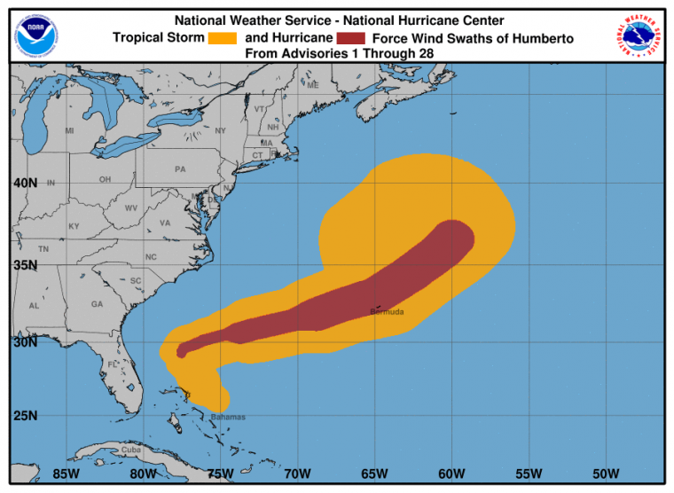
Hurricane Humberto wind history. Source: NOAA/NHC.
Remnants of Imelda – Flood Threat for Texas and Louisiana Gulf Coast
Current Status (11 AM EDT/15 UTC WPC Advisory)
- Location: About 55 miles north of Houston, Texas
- Maximum sustained winds: 25 mph
- Motion: northwest at 6 mph
- Minimum central pressure: 1009 mb
The U.S. Weather Prediction Center (WPC) continues to follow the remnants of Imelda this morning following the last advisory from the NHC on Wednesday. After making landfall as a minimal tropical storm on Tuesday, Imelda quickly weakened to a Tropical Depression. As of Thursday afternoon the very slow moving system was loosely organized to the north of Houston, however rain bands extend to the coast from Houston, Texas to Jennings, Louisiana. The bands of the system have produced an active tornado threat for affected areas and tornado warnings are still being issued for areas under immediate threat.
Imelda is also expected to produce widespread rainfall totals of 5 to 10 inches, with local totals of 25 to 35 inches. These rainfall totals will continue to bring significant to life-threatening flash flooding.
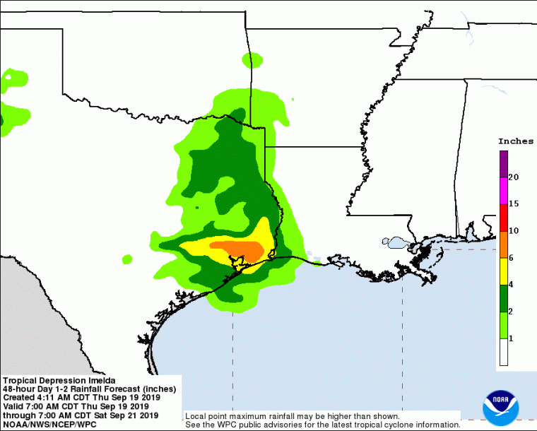
48-Hour precipitation forecast. Source: NOAA/WPC.
Persistent bands of storms progressing east toward Beaumont have been producing extremely heavy rainfall with rainfall rates of 3-5 inches per hour. In the last 12 hours, the City of Beaumont averaged more than 12 inches of rainfall, with some areas receiving up to 20 inches. Rivers in the Beaumont and Houston regions are in a moderate to major flood stage. Overnight, the rainfall and flood threat is expected to shift slightly north. Additionally, elevated tide levels and currents are expected along the coast through Friday.
The remnants of Imelda are expected to continue moving inland before dissipating before tomorrow morning. Regardless of status, the system remains a significant flood threat for the Texas and Louisiana Gulf Coast with an ongoing threat for some tornadoes. The U.S. National Weather Service maintains watches and warnings to this effect.
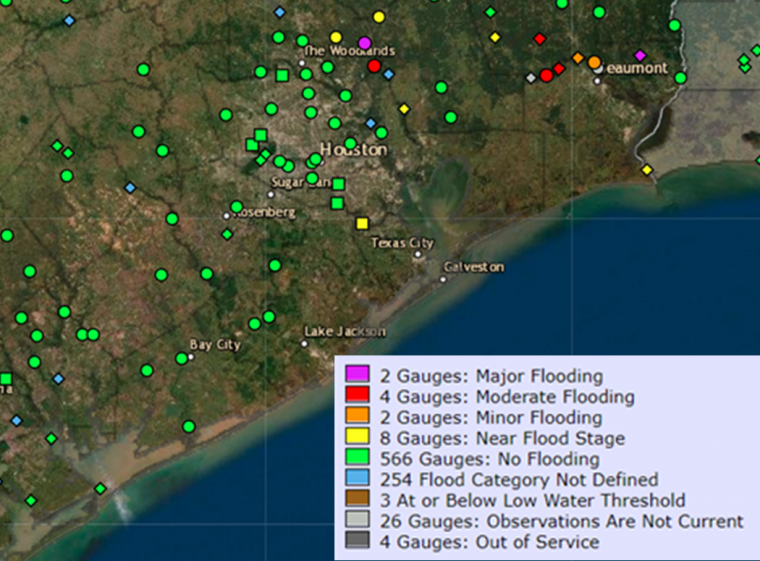
River Flood Stage Observations. Source: NOAA/NWS.
Hurricane Jerry
Current Status (2 PM EDT/18 UTC NHC Advisory)
- Location: About 435 miles east of the Leeward Islands
- Maximum sustained winds: 85 mph
- Motion: west-northwest at 16 mph
- Minimum central pressure: 982 mb
- Extent of hurricane-force winds: 20 miles
- Extent of tropical-storm-force winds: 80 miles
- Status: category-1 hurricane
Hurricane Jerry is on a west-northwesterly track and on a course to pass well to the north of the Leeward Islands on Friday. Some gain in strength is possible in the meantime. Tropical storm conditions remain possible for portions of the Leeward Islands and tropical storm watches are now active. Over the longer term, Jerry is expected by the NHC to make a slow turn to the north and northeast early next week, although the timing and placement of this turn remains uncertain. The storm poses a potential threat to Bermuda for next week.
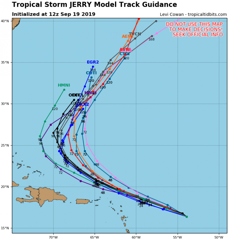
Model track guidance. Source: tropicaltidbits.com.
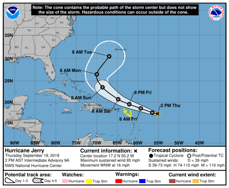
Position and best track forecast. Source: NOAA/NHC.
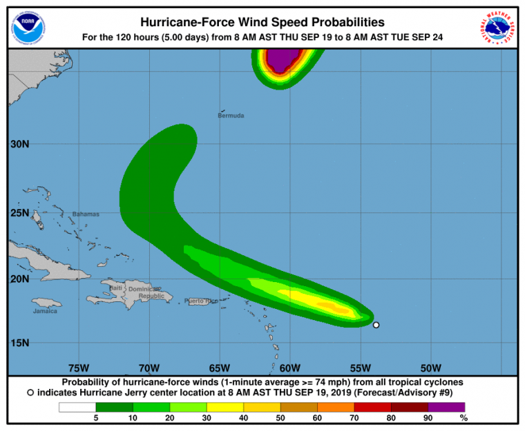
Probability of hurricane-force winds. Source: NOAA/NHC.
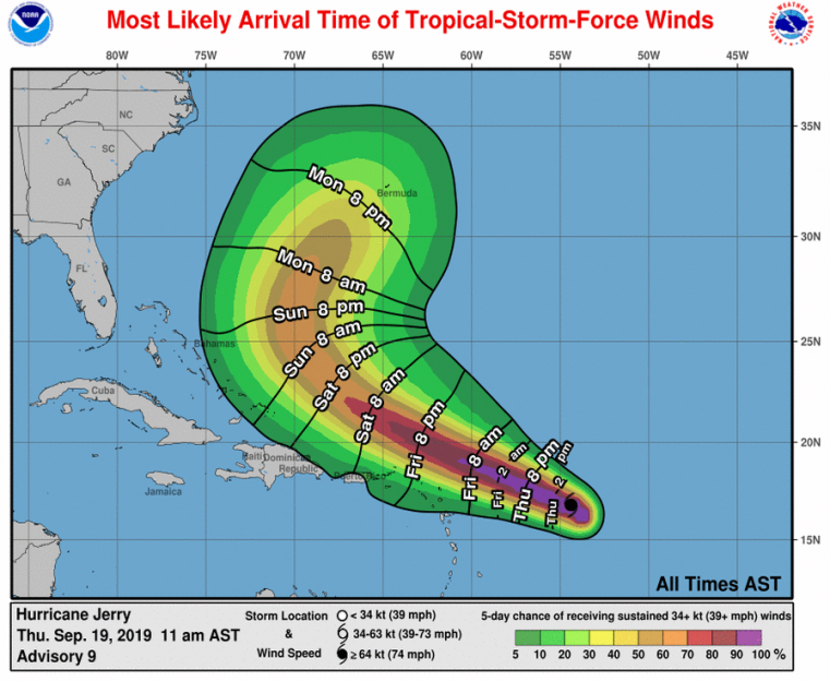
Most likely arrival time of tropical-storm-force winds and probabilities. Source: NOAA/NHC.
Further Sentinel updates on these features will resume if a material and escalating threat for hurricane impacts becomes apparent affecting the Americas. Real-time updates can be found in the meantime by using the links below.
The NHC and other official agencies maintain watches and warnings for areas under potential or immediate threat. Specifics can be found at www.nhc.noaa.gov and www.weather.gov. Official watches and warnings, and statements from emergency management agencies supersede this update, and should be closely followed concerning matters of personal safety.
For up to date, official information the following websites are recommended:
Mexico National Weather Service
Subscribe to Guy Carpenter Email Alerts on Real Time Activity
To receive email notifications of Weather Sentinel updates, please click on this link to update your preferences.
https://go.guycarp.com/preferencecenter
Additionally, in response to client demand, we are pleased to offer daily email alerts for any tropical cyclone occurring globally. The GC Global Tropical Cyclone Alert discusses active tropical cyclones across the globe, portraying a graphical forecast and brief commentary on intensity forecast changes expected over a 24 hour period. Fill out the form at the link below to start receiving our key insights.