

Overnight, firefighters took advantage of a break in Santa Ana wind conditions to enhance containment of the Kincade Fire in Northern California, and the Getty Fire in Southern California. Collectively, nearly 135 structures have been lost, while many thousands remain threatened and evacuated. Offshore flow is forecast to strengthen during the mid-day in the Bay Area and Sacramento Valley and progress south to the Los Angeles area by late night Tuesday. Strong sustained winds and gusts, critically low relative humidity, and complex terrain will make firefighting efforts increasingly challenging today through Wednesday.
Kincade Fire and Northern California
Activity on the Kincade Fire has been limited in the past 24 hours, as winds have been light and firefighters have been aggressively reinforcing containment lines. Containment is now estimated at 15%, with 123 structures destroyed and a further 90,000 structures threatened in Geyserville, Healdsburg, Windsor and Santa Rosa. The onset of offshore winds should occur around noon today, driving down humidity levels and causing strong winds and gusts from the northeast. Complex terrain will enhance localized winds, while also complicating firefighting efforts.
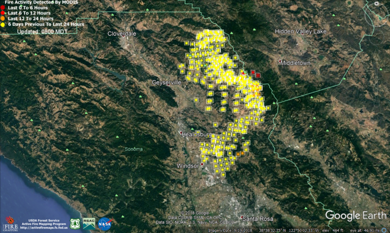
Approximate location of the Kincade Fire in Sonoma County. Fire Detection in last 6 hours (dark red), last 12 hours (red), last 24 hours (orange), beyond 24 hours (yellow) Source: USFS/MODIS
In addition to strong winds in the North Bay mountains, offshore flow is expected to encompass the Sacramento Valley this afternoon, including the foothills of the Sierra Nevada mountains. Nearly 17 million people are expected to experience critical fire weather today, with localized extreme fire weather possible in isolated terrain. This combination of dry and windy weather means that fires will ignite easier and will spread rapidly.
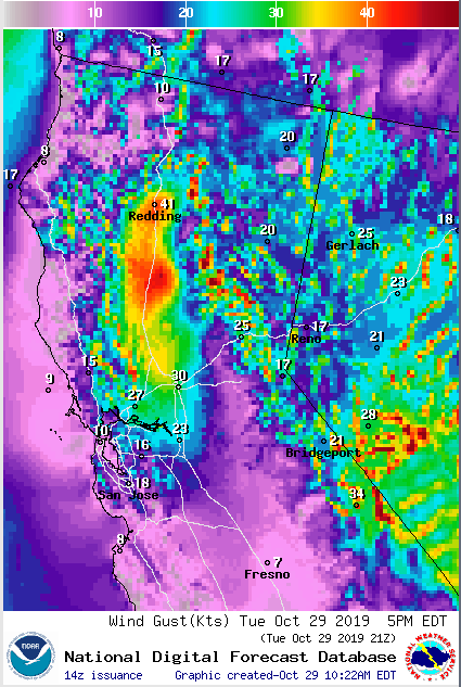
Surface wind gust forecast for 5 pm Tuesday. Widespread red shading representing wind gusts in excess of 50 mph in the western Sacremento Valley. Source: NWS/Sacramento Office
Getty Fire and Southern California
Recent activity on the Getty Fire has been limited, as winds are onshore and humidity is improving. Firefighters are using these favorable conditions to build containment lines and protect structures in the evacuation zone to the west of the current fire extent. The Getty Fire is 5% contained, 8 residential structures have been lost, 6 have been damaged, and many thousands remain threatened. Once offshore flow resumes later today, areas to the south and west of the current fire extent will be at risk.
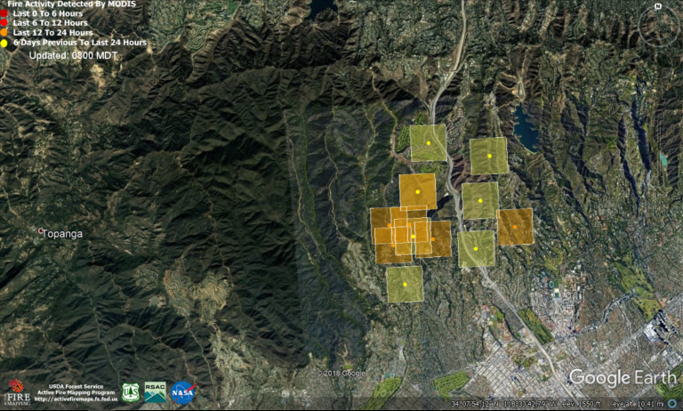
Approximate location of the Getty Fire in Los Angeles. Fire Detection in last 6 hours (dark red), last 12 hours (red), last 24 hours (orange), beyond 24 hours (yellow) Source: USFS/MODIS
The expectation is that the Santa Ana winds will return in the late evening on Tuesday, and could be the strongest yet experienced this year. The Los Angeles Weather Service Office has issued an Extreme Red Flag Warning, forecasting isolated wind gusts up to 80 mph in the Santa Monica and Los Angeles County mountains. There is a high potential for very rapid fire spread, extreme fire behavior and long range spotting.
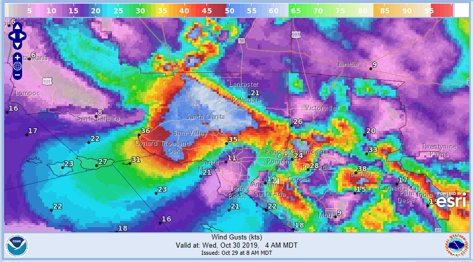
Surface wind gust forecast for 4 am Wednesday. Widespread light blue shading representing wind gusts in excess of 50 mph in the Santa Monica and Los Angeles County Mountains. Source: NWS/Los Angeles Office
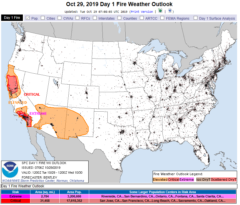
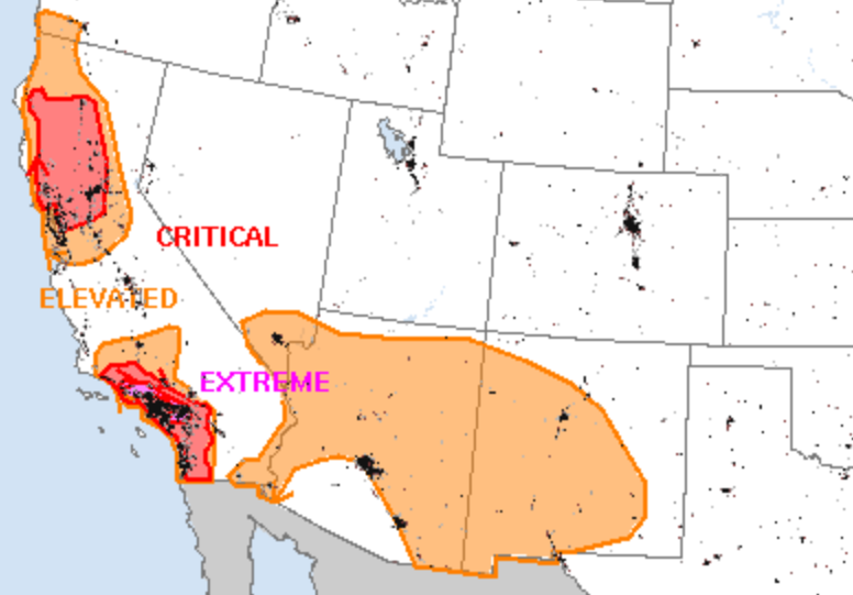
Fire Weather Outlook today. Pink – Extremely Critical risk; Red – Critical risk; Orange – Elevated risk. Source: NOAA/SPC
This report was compiled with integrated information from the public agencies listed below. Regional conditions can vary depending on local weather conditions. Interested parties can monitor the sites below for updates and developments, and statements from these sites supersede this update.
NOAA/NWS Storm Prediction Center
California Department of Forestry and Fire Protection (CalFire)