
March Recap Traditionally, the month of March marks the onset of the severe weather season across the United States. While severe thunderstorm activity can happen at any point during the year, the peak of activity typically occurs during the months of March, April and May. Here are some highlights that took place over the last month.
- March began abruptly with a sizable industry loss from a tornado outbreak impacting the Nashville metro region and central Tennessee on March 3. More information on this event is available in the Guy Carpenter CAT-i report found here.
- Severe convective activity across the United States through the middle of March remained otherwise relatively quiet, with only a few days of localized activity.
- Activity saw an uptick over the weekend of March 27-28, with widespread hail, wind, and tornadoes impacting areas of the Midwest and Southeast, including an EF-3 tornado impacting Jonesboro, Arkansas. More information on that outbreak can be found below.
- High winds and at least three tornadoes impacted a broad area of the Deep South on March 31.
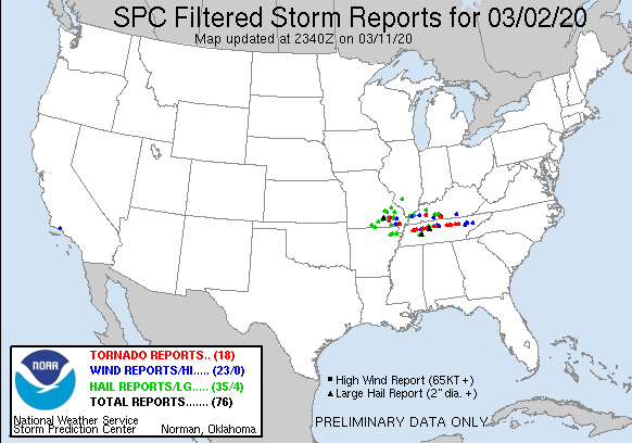
Local storm reports spanning March 2 - March 4. Source: NOAA/SPC.
On Saturday, March 27, a weather system spawned multiple tornadoes across northeast Arkansas. The largest tornado, rated EF-3 by the National Weather Service, packed estimated winds of 140 mph and rendered significant damage to a local mall, the Jonesboro, AR airport, and a number of residences and large industrial buildings. The tornado gained notable media attention as it was picked up by a highway camera during a live broadcast of a local news station and The Weather Channel.
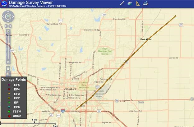
March 27 EF-3 tornado track affecting Jonesboro, AR.Source: NOAA/NWS Damage Assessment Toolkit.
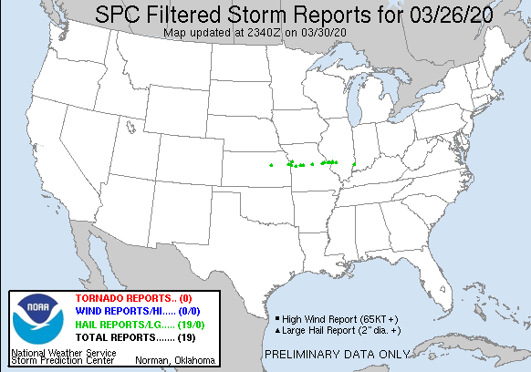
Local storm reports spanning March 26 - March 31.Source: NOAA/SPC
How is the 2020 season progressing?
The below image indicates the minimum, maximum, and average number of tornadoes over the last 20 years, cumulative through the first three months of the year. 2015 was well below average with only 42 tornadoes across the United States by March 31. In contrast, 2017 got off to quick start, with over 400 tornadoes reported by the end March. While 2020 sits just slightly above the 2000-2018 average, this year falls well in the middle range of activity over the past 20 years. Additionally, tornado activity is fairly consistent with what it was at this time last year.
![]()
Tornado counts through March 31, with 20-year average and notable anomalies. Sources: NOAA/SPC WCM for 2000-2018 and 2020; Iowa Mesonet for 2019, scaled by 0.85 to correct overcount per SPC methodology.
Relative to the 2005-2015 average, each of the severe convective subperils is performing at its own pace. Each icon on the below plot indicates subperil progression through the season on the horizontal axis and the percent above or below average on the vertical axis, as of March 31. Due to an active January and February, damaging straight line wind reports for 2020 are trending roughly 50 percent above normal for this time of year and the season is roughly 11 percent complete. Tornado reports are closest to average through the end of March and the subperil is furthest along in the season, at roughly 16 percent complete. Hail reports for this time of year are significantly below average and are trailing the other two subperils at roughly only 5 percent of completion.
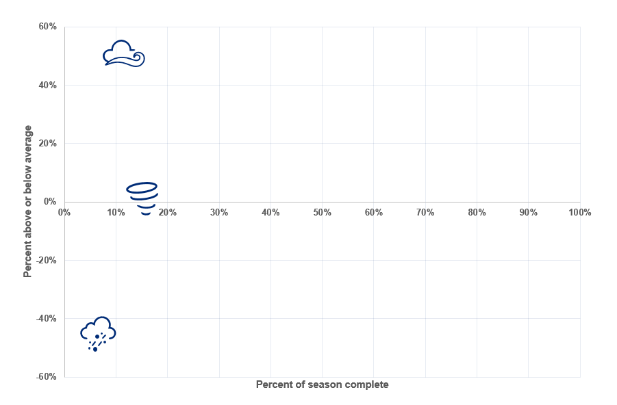
Seasonal activity to date for tornado, hail and thunderstorm wind, relative to 2005-2015 averages using SPC preliminary local storm reports. Source: NOAA/SPC.
April Forecast
The potential for scattered thunderstorms towards the end of the week in the southern Plains and over Texas will emerge from a sharp cold front moving across the area. Beyond the 3 day period, the expected threat for severe weather becomes minimal as a mid-level ridge builds over the Gulf states this coming weekend and into the week of April 6th.
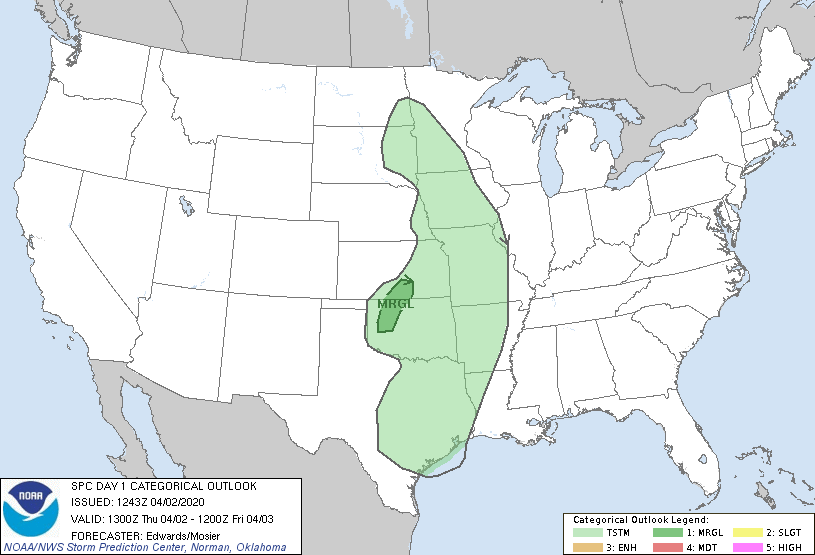
SPC Convective outlook animation as of April 2 (morning). Source: NOAA/SPC.
Forecast skill for severe-weather environments declines after 72 hours, and especially after 8 days. However, Dr. Victor Gensini of Northern Illinois University has recently made advancements in extended range forecasting. The Extended Range Tornado Activity Forecasts (ERTAF) provide a long range severe weather forecast two and three weeks out. The most recent forecast, published on March 28, called for below average activity from April 5 to April 11, consistent with split flow in upper levels of the atmosphere and ridging of high pressure over the central U.S., as indicated by the below weather model output. The long range forecast beyond 10 days starts to show the potential of a heightened period of activity in the middle third of the month as a deep trough over the western US potentially progresses into the Plains.

500 mb Geopotential Height forecast beginning April 8 through April 12. Source: TropicalTidbits.
This issue of the Weather Sentinel is published as a series of regular communications during the 2020 SCS season. If a significant industry threat of severe weather occurs, further communication will be issued by Guy Carpenter experts as warranted.