


With two thirds of May in the rear-view mirror, we are nearing the usual peak of US severe thunderstorm activity. Significant outbreaks are still possible across much of the US during the rest of the calendar year, and this activity tends to decline heading into the deep summer months. Here is a look at some of the intermittent severe weather that impacted the US during the month of May:
- A strong frontal system brought severe thunderstorms stretching from Kansas southeast to parts of South Carolina during the first week of the month.
- A low pressure system produced thunderstorms across much of the south-central plains later that week, bringing impacts of 2+ inch hail to parts of Kansas, Oklahoma, Texas, and Louisiana.
- Widespread severe thunderstorm activity occurred across much of the central and eastern portions of the US from May 13-15, including significant wind activity in the Northeast.
- Multiple lower-severity tornadoes were reported in Texas, Arkansas, Louisiana and Illinois during May 16-17, as several storms moved through the central part of the US.

Satellite imagery including lightning strike data via the Geostationary Lightning Mapper (GLM), GOES-16, showing the formation of a supercell in Texas and Oklahoma on May 7. Source: D. Smith, CIRA/CSU
Wind, Hail and Tornado: Above, Below and Average
A winter with elevated straight-line wind activity, including two distinct peaks in both January and February, boosted 2020 numbers to well above the 20-year average. With continued heightened activity through April and May, damaging straight-line wind reports for the year currently sit nearly 50 percent above the 20-year average. Of particular interest is that of the three sub-perils, only damaging straight-line wind reports are trending above average thus far in 2020.
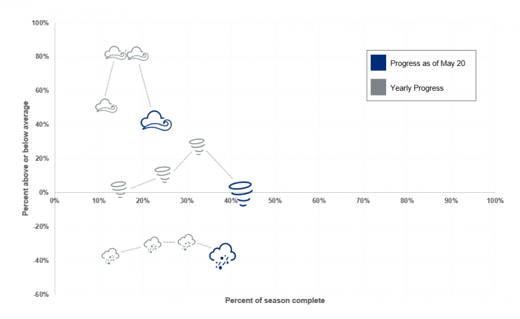
Seasonal activity to date for tornado, hail and thunderstorm wind, relative to 20 year average using SPC preliminary local storm reports. Source: Guy Carpenter, NOAA/SPC
In sharp contrast, hail activity, which is typically a large insured loss driver, is significantly below average for 2020. A near-stagnant March put hail reports below the 20-year normal, and that pace has continued through the rest of the spring.
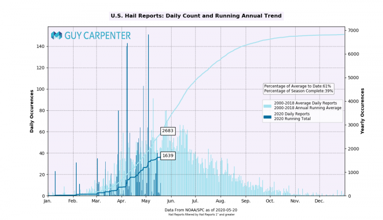
Daily Count and Running Annual Trend of US Hail reports to date (1+ inches). 2020 in dark blue, 2000-2018 average in light blue. Source: NOAA/SPC, Guy Carpenter
In fact, 2020 has been such a low hail year that its current progression to date is lower than that of any of the past 10 years, as shown in the graphic below. The unseasonably cool temperatures during much of April and May across the northern two-thirds of the US have brought less favorable conditions for hail formation.
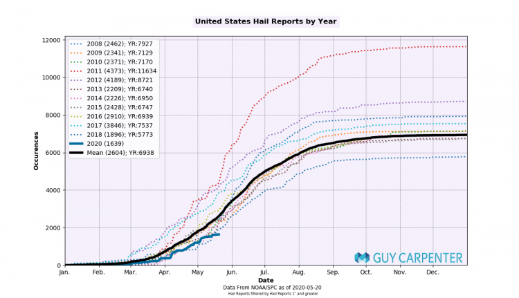
Running Annual Trend of US Hail reports since 2008 (1+ inches). 2020 in blue. 2000-2018 average in black. Source: NOAA/SPC, Guy Carpenter
Despite periodic activity through the month of May, the overall lack of significant severe weather outbreaks this month has brought tornado reports back towards average. As discussed in previous posts, above average tornado seasons are typically marked by continued above average activity through the month of May, which has not been observed to date in 2020.
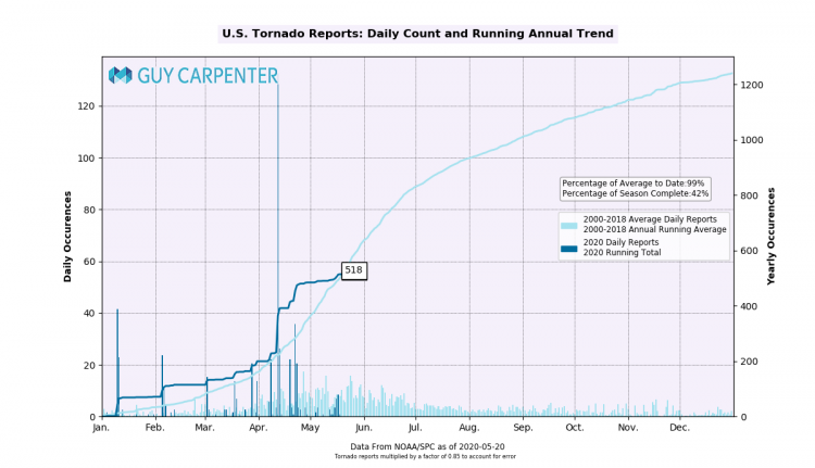
Daily Count and Running Annual Trend of US Tornadoes to date. 2020 in dark blue, 2000-2018 average in light blue. Source: NOAA/SPC, Guy Carpenter
Forecast
Widespread risk for severe thunderstorms is possible over the next few days and through the weekend, as indicated by the US Storm Prediction Center. Parts of the southern and central High Plains, in addition to areas along the southern East Coast, could see marginally severe thunderstorms form today. The potential for thunderstorm development in much of the central and eastern portions of the country is expected to continue on Friday and Saturday, with the highest risk on Saturday in the northern and central Great Plains regions. Moving into the last week of May, the Extended Range Tornado Activity Forecasts (ERTAF) out of Northern Illinois University call for average activity through May 30 and long-term guidance indicates continued low potential for organized severe weather at the regional level.
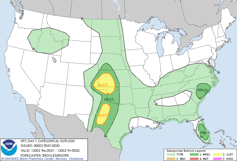
SPC Convective outlook animation as of May 21 (morning). Source: NOAA/SPC
Looking forward into June, climatologically, hail and wind tend to exhibit an uptick in activity while tornado beings to trend downwards. Guy Carpenter experts will continue to monitor severe activity through the summer, in addition to any upcoming tropical activity.
If you would like daily updates on global tropical cyclone activity worldwide, please visit the GC Global Tropical Cyclone Alert Subscription page.
This issue of the Weather Sentinel is published as a series of regular communications during the 2020 US SCS season. If a significant industry threat of severe weather occurs, further communication will be issued by Guy Carpenter experts as warranted.