


Looking forward to the 2020 Atlantic hurricane season, seasonal outlook providers are forecasting an active season in the North Atlantic Basin. The numbers include a forecast of nine hurricanes and four major hurricanes in the Basin, relative to averages of six and two, respectively, according to Phil Klotzbach of Colorado State University. The season is already off to a record fast start, with the third named storm, Tropical Storm Cristobal, forming on Tuesday, a full three days before the prior record fast start.
Unanimously among perennial seasonal forecast entities, forecasts call for above average Atlantic tropical cyclone activity, as indicated in the chart below. Additionally, in the latest Colorado State University forecast issued June 4, the total number of named storms increased from 16 to 19 while the number of hurricanes anticipated increased from 8 to 9 versus the prior forecast.
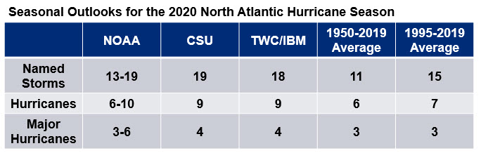
Seasonal forecasts as of June 4, 2020 from various perennial providers. Source: NOAA/CSU/IBM. Multiple factors are in play trending towards above normal activity in the Gulf and Atlantic Main Development Region. The strongest variable entering the hurricane season is the elevated sea surface temperatures (SSTs) across the tropical Atlantic, Caribbean and Gulf of Mexico. The animation of SSTs illustrates the persistently above average temperatures in this region thus far in 2020.
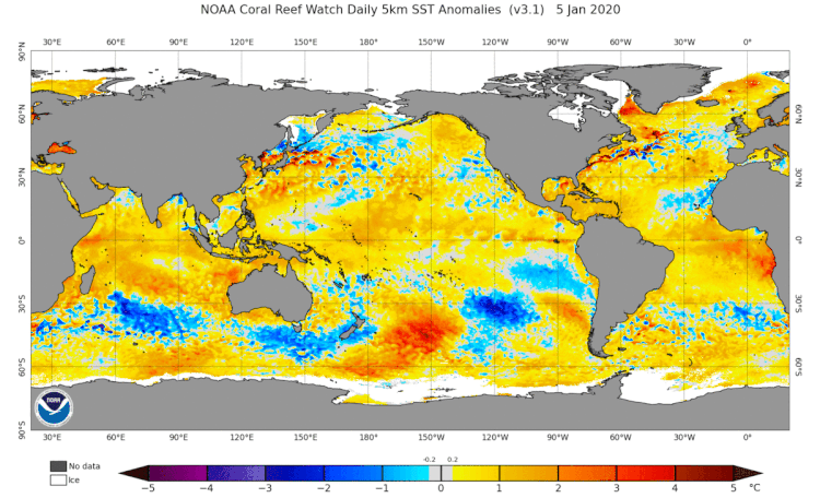
Global Sea Surface Temperature Anomalies every 15 days in 2020. Source: NOAA Coral Reef Watch. Another key factor is a prediction by the NOAA Climate Prediction Center for neutral to possibly weak La Niña conditions for the 2020 season. The SST anomaly animation shown above highlights the colder than average SSTs starting to emerge in the central and eastern Pacific Basin along the equator. While a suite of models predicts an equal chance of neutral and La Niña conditions during the heart of the Atlantic season, there is a significant amount of colder than average sub-surface temperatures. The 90 day animation of the central/eastern equatorial Pacific highlights how these colder than average water temperatures are moving to the surface (shown at the top of animation). This indicates the end of last winter's El Niño event and a potential transition to a summer La Niña may be more likely than neutral conditions in the coming months.
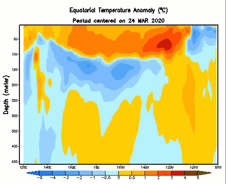
Animation of colder than average sub-surface ocean temperatures in the tropical Atlantic moving towards the surface, indicative of a potential shift towards La Niña conditions for the upcoming summer. Source: NOAA/CPC. A third area of growing research in recent years is the ability for Saharan Dust to move west across the tropical Atlantic atmosphere. Saharan dust indicates lower humidity profiles which adversely impacts the ability for tropical disturbances to maintain thunderstorm activity for further development. Drier conditions can inhibit the summer West African monsoon, making the disturbances that emerge off Africa weaker than average. In contrast to several recent years, spring rainfall totals across west Africa has been well above normal. Research indicates that wet springs are one of several factors that can decrease dust transport during summer, which in the case of 2020 also points towards elevated potential in the deep tropics for storm formation.
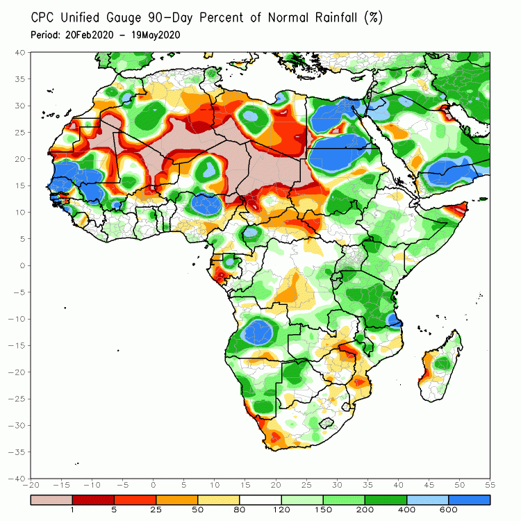
Three month rainfall as a percentage of normal across Africa. Except for the lack of any precipitation across the Sahara Desert, other areas have featured above average rainfall activity which may promote more favorable conditions for deep tropical development this summer. Source: NOAA/Africa Desk.
Landfalls, of course, are of key interest to the industry, and closely depend on surrounding weather systems in play at the time of the hurricane. The resulting steering currents are not predictable with meaningful skill beyond a 7-10 day timeframe. We should also be aware that the Atlantic Basin-to-US landfall ratio varies widely in any given year, from no landfalls at all to the majority of storms making landfall. While on average the ratio is approximately 20-25%, there is no skill in June to predict where and how many landfalls may ultimately occur, with year-to-year volatility quite large.
Weather Sentinel updates will be issued for the Atlantic Basin during the 2020 season if a landfalling hurricane is threatening a region of insured exposure.
To receive email notifications of Weather Sentinel updates, please visit the GC Preference Center.
Would you like daily updates on global tropical cyclone activity worldwide? If so, visit the GC Global Tropical Cyclone Alert Subscription page.