
With fires already burning in Florida and the Southwest, seasonal dryness and heat are beginning to cure fuels in the western US. Portions of the Rockies, Southwest, and Northern California have experienced large precipitation deficits over winter, and significant wildfire potential is above normal.
Drought Conditions and Forecast
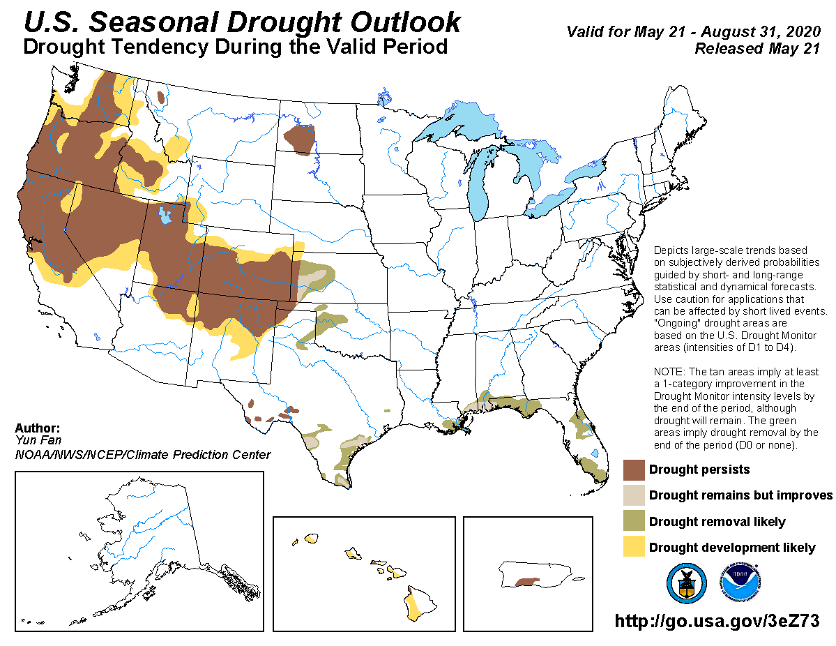
- Although the second half of May brought several wet low pressures systems to the Pacific Northwest and coastal California, a winter characterized by well below average precipitation is keeping the region in a state of severe to extreme drought.
- Southern California has experienced well below average precipitation in the month of May, however ample winter season precipitation is keeping the region out of a drought state.
- Northern Florida is experiencing moderate to severe drought, which led to the initiation of several large fires in the month of May, however recent tropical moisture and seasonal rains have significantly reduced activity going into June.
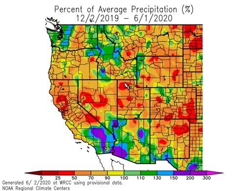
Precipitation departure from average for winter months of Dec - June (NOAA Regional Climate Centers)
- Above average temperatures across much of the west have resulted in an acceleration of mountain snowpack melting, negatively impacting portions of the Rockies, Sierra, Cascades and Great Basin regions.
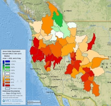
Snowpack percentage of normal for June 2020
- Currently, nearly 8% of the US is in a state of severe to extreme drought, with no areas yet in a state of exceptional drought.
- The most likely outcome is for current drought to persist and for potential new drought development in areas adjacent to currently drought affected areas; driven by the expectation of warm summer temperatures coupled with below average precipitation.
- Nearly all precipitation outlooks indicate an improvement in drought conditions all along the Gulf Coast, already aided by the landfall of Tropical Storm Cristobal over the weekend.
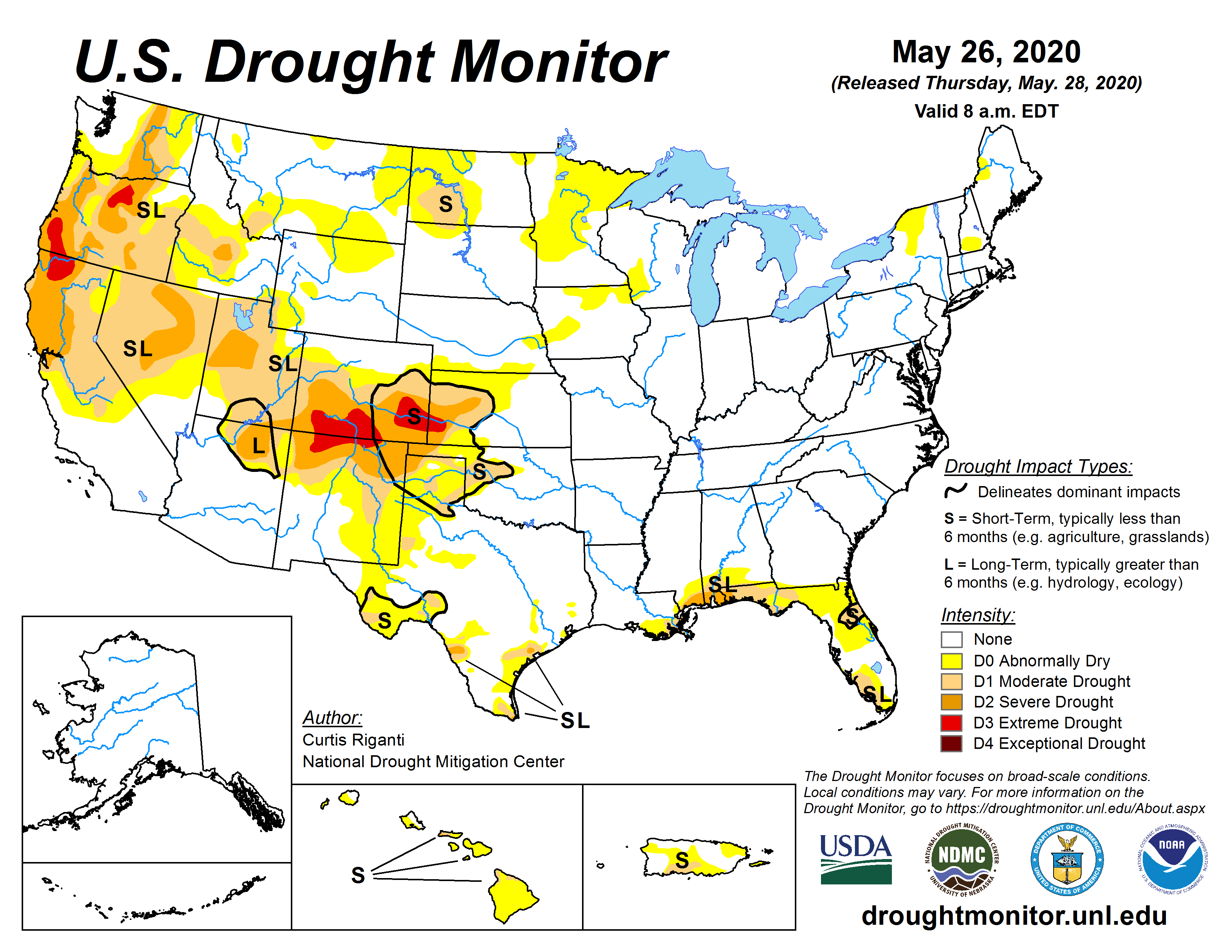
US Drought Monitor, May 26, 2020
US Seasonal Drought Outlook valid for June, July, August 2020 (NOAA/CPC)
Climatological Outlook
- Current indications are that a weak La Niña is developing, however there is little predictability in the summer months based on ENSO, especially when the signal is quite weak.
- Temperatures are expected to be warmer than average across the entire United States, including Alaska, for the months of June, July and August.
- The confidence about a warmer than average summer is highest for Alaska, the desert Southwest and the Sierra Nevadas.
- A forecast of warm temperatures, coupled with an already warmer than average May, means that fine fuels are already curing, with larger fuels beginning to dry out in the coming weeks and becoming more receptive to wildfire.
- An early run-off and melting of the mountain snowpack means that the protective layer of snow that typically prevents an early drying out of fuels in mountainous regions is less than normal, or perhaps already completely melted in some areas.
- Summer precipitation is expected to be below average in the Pacific Northwest and Rocky Mountain regions.
- Precipitation in California is always sparse during the summer months, which when coupled with very warm temperatures, could mean an elevated risk of wildfire in the summer months.
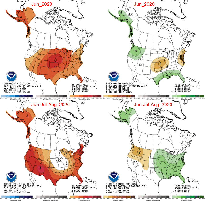
One month (top) and three month (bottom) outlooks for temperature (left) and precipitation (right) (NOAA Climate Centers)
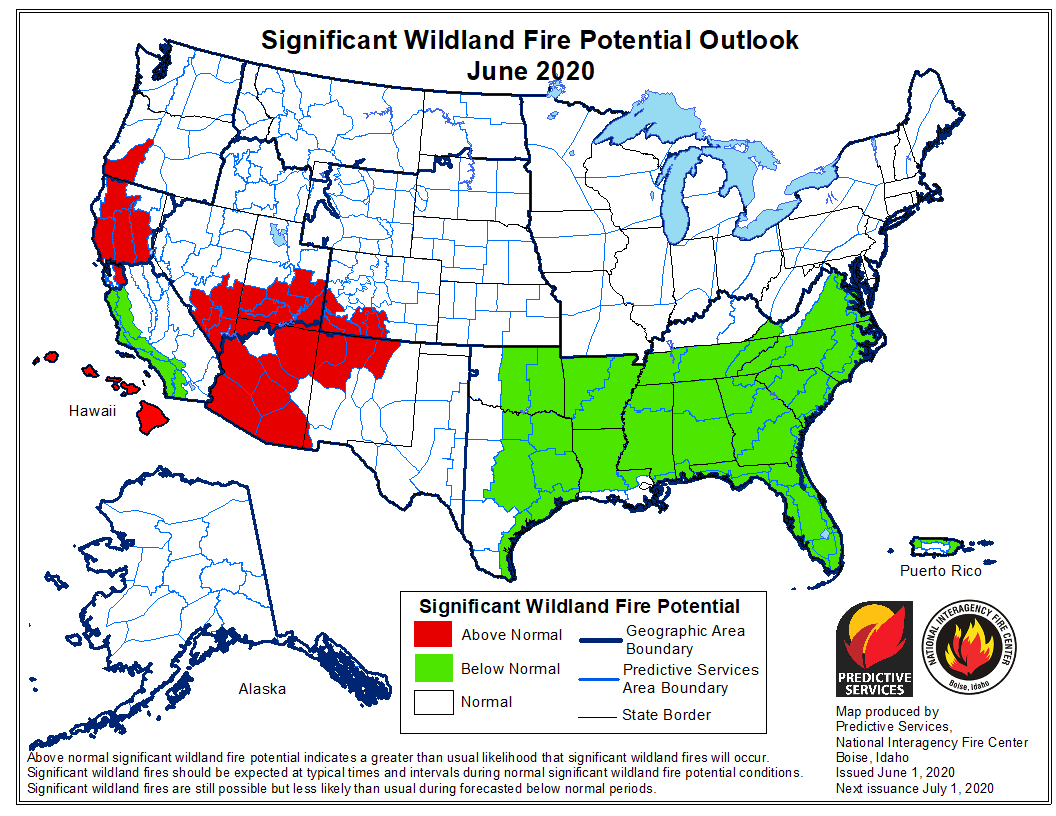
Significant Wildfire Outlooks
- Above average precipitation along the Gulf Coast is gradually lessening the risk of wildfire, especially in Florida, which has already seen an active fire season this spring.
- A rainy second half of May, coupled with above average precipitation in the winter months is keeping coastal and southern California at below normal risk for wildfire heading into June, however by July the above average temperature forecast puts southern California back into a normal state of wildland fire potential.
- Below average winter precipitation and a warm May in the Rocky Mountains and Northern California mean there is an above normal wildfire potential leading into the summer months.
- Above normal wildland fire potential extends into the Pacific Northwest heading into July, as the expectation is for a drier and warmer than average summer.
- It should be noted that large and damaging wildfires can occur even in areas of below normal wildland fire potential.
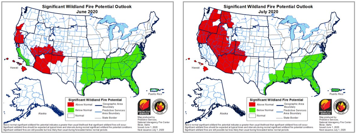
Significant Wildland Fire Potential Outlook for June (left) and July (right) (Predictive Services and National Interagency Fire Center)
Canada
- Heading into the month of June, wildfire activity in Canada is well below average (burned area is only 10% of normal).
- Snow cover remains in the mountainous areas of the western Provinces, which is expected to gradually melt in the month of June and introduce increased wildfire activity.
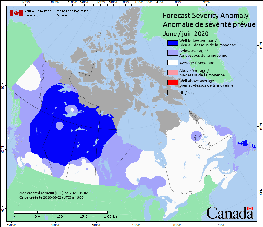
Wildfire Forecast Severity Anomaly, June 2020 (CWFIS)
- Most climate models predict warmer than average temperatures across Canada by mid to late June, and the latest rainfall predictions favor dry conditions in British Columbia, Alberta, and the Northwest Territories.
- This pattern will lead to a drying out of fuels, which will be vulnerable to lightning strike ignitions as summer thunderstorm activity increases, especially in BC and Alberta.
- While climatological patterns indicate an increased risk of wildfire activity my mid summer, there are significant burn restrictions in place in most of Canada due to COVID-19, which may reduce human caused ignitions.
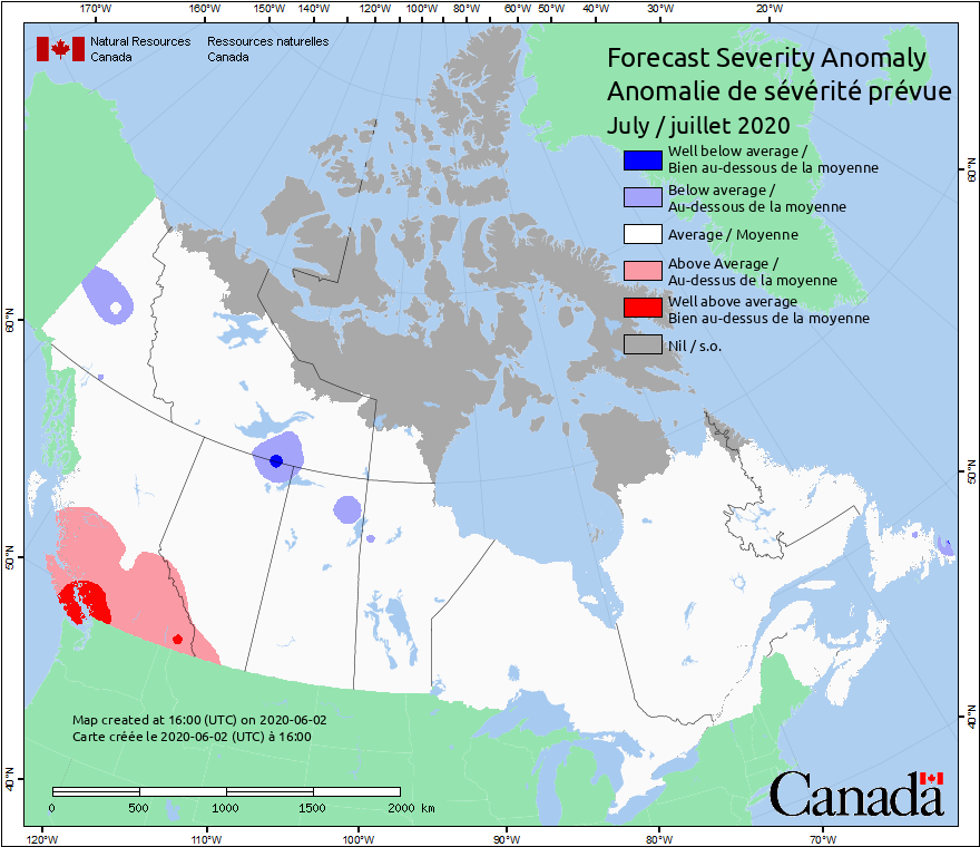
Wildfire Forecast Severity Anomaly, July 2020 (CWFIS). Weather Sentinel updates will be issued for North America during the 2020 wildfire season if an event is threatening a region of insured exposure. Monthly outlooks of significant wildfire potential will also be issued monthly to monitor areas of increased risk during the 2020 season. To receive email notifications of Weather Sentinel updates, please visit the GC Preference Center.