

As wildfire season continues in the US, fire activity is occurring in ten states, where 33 large wildfires are currently burning and have consumed 425,000 acres. During June, drought coverage expanded and intensified across much of the Great Plains and Intermountain West, and fire activity intensified as fine fuels became critically dry. This drought expansion into the core of the Western US fire season is resulting in a forecast of Above Normal significant large fire potential from the Great Basin north into California and the Pacific Northwest.
Drought Conditions and Forecast
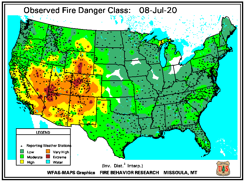
- The month of June was characterized by persistent heat and drought in the Western US, resulting in a significant fuel moisture deficit. Observed 10-hour fuel moisture percentage is at 1-2% for large portions of Nevada, Utah, Arizona and parts of California. 10-hour fuels are finer fuels that respond quickly to changing weather conditions, such as fine grasses. Vegetation with fuel moisture percentages below 6% (oranges to reds in the below figure) will be very reception to spot fires.
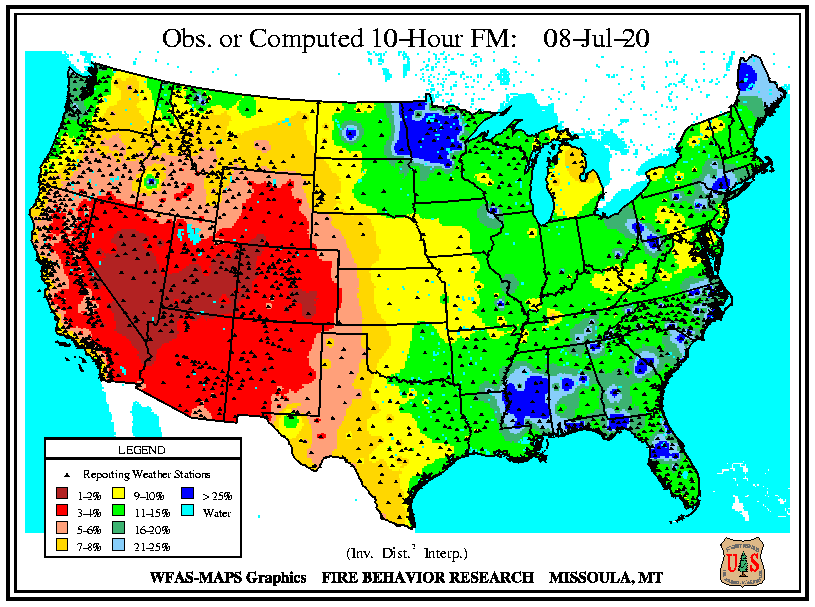
10-Hour Fuel Moisture July 8 (USFS Wildland Fire Assessment System)
- The months long precipitation deficit has also resulted in the curing of larger fuels. The 1000-hour fuel moisture percentage is also extremely low; less than 5% in some areas represented in orange below. 1000-hour fuels respond slowly to changing weather conditions and are indicative of long-term drought and elevated summer fire activity. The finer fuels will be quick to ignite and spread to the larger cured fuels, which have the potential to burn intensely.
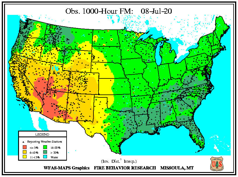
1000-Hour Fuel Moisture Percentage from July 8 (USFS Wildland Fire Assessment System)
- The pattern of drought that has developed in the early part of the summer is expected to persist through the Great Basin and Intermountain West, and begin to intensify to the south and east.
- By the end of July, the expectation is that most of northern California, the Great Basin, and the Rockies will be in a state of extreme to exceptional drought.
- Southern California experienced a series of weather patterns in June that brought alternating hot/dry and cool/wet conditions that on balance kept the region out of a drought state for the time being. Normal sea surface temperatures off the coast should mitigate extreme heat and the development of drought conditions in the near term.
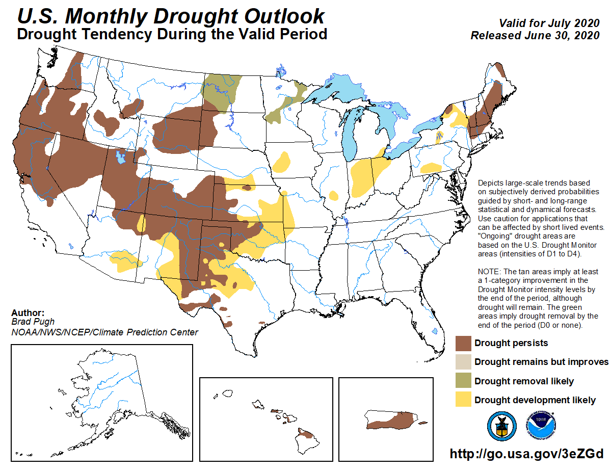
US Seasonal Drought Outlook valid for July, August, September 2020 (NOAA/CPC)
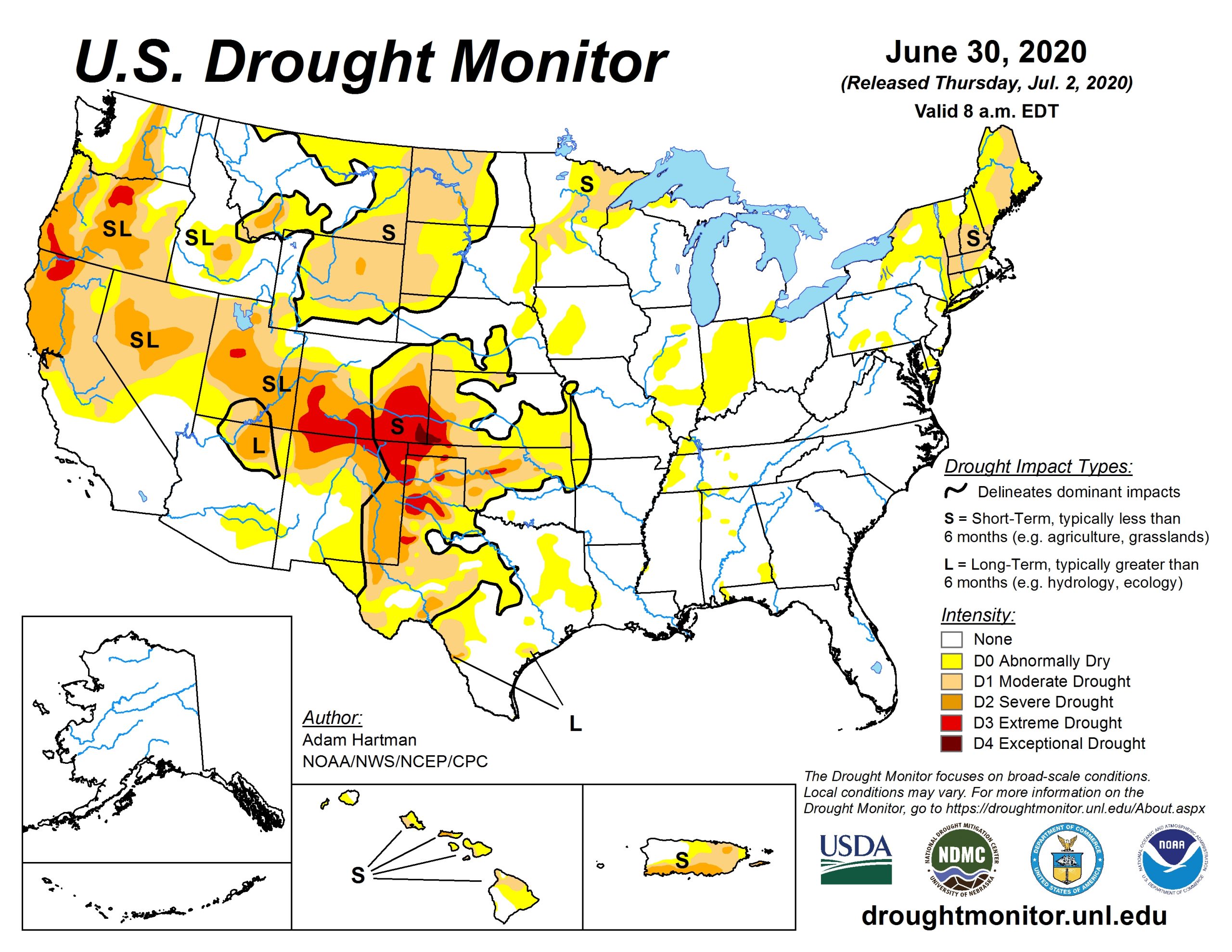
US Drought Monitor, June 30, 2020
Climatological Outlook
- As expected, June was a transition month for sea surface temperatures in the waters around the equator, where upwelling of cold waters is shifting the pattern toward a weak La Nina, which is expected to strengthen toward fall.
- The development of a weak La Nina during the peak of wildfire season needs to be closely monitored, as it could mean the onset of significantly warmer and drier weather than is typical in the northern Rockies and western US.
- A forecast of warm temperatures through the summer, coupled with an already warmer than average spring, means that both fine and larger fuels are becoming more receptive to ignition and high intensity spread.
- Summer precipitation is expected to be below average in the Pacific Northwest, Rockies, and Plains regions.
- Precipitation in California is always sparse during the summer months, which when coupled with very warm temperatures, could mean an elevated risk of wildfire in the summer months.
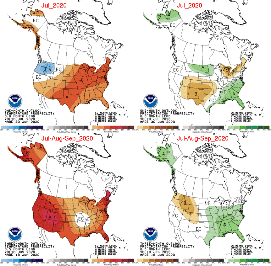
One month (top) and three month (bottom) outlooks for temperature (left) and precipitation (right) (NOAA Climate Centers)
Significant Wildfire Outlooks
- A generally wet and humid pattern, related to the developing La Nina, is expected to persist in the Southeast US and keep significant wildland fire activity below normal.
- Periodic wet patterns over the past several months have brought enough moisture to keep Southern California in a normal significant wildland fire potential moving into mid summer.
- Below average winter precipitation coupled with a warm spring and early summer in the Intermountain West, Great Basin and Northern California mean there is an above normal significant wildfire potential leading into mid summer.
- Above normal significant wildland fire potential extends into the Pacific Northwest and Northern Rockies heading into August, as the expectation is for a drier and warmer than average summer.
- It should be noted that large and damaging wildfires can occur even in areas of below normal significant wildland fire potential.

Significant Wildland Fire Potential Outlook for July (left) and August (right) (Predictive Services and National Interagency Fire Center)
Canada
- Wildland fire activity in Canada is much below average as measured by number of fires (70% of normal) and acreage burned (20% of normal).
- There are significant COVID related fire restrictions in place in Quebec, Ontario and Alberta, while other provinces have no fire bans.
- Western Canada has received ample precipitation in early summer, with strong Pacific storms periodically providing rainfall and below average temperatures.
- Snow cover remains along the high peaks in the Canadian Rockies, and in pockets in the Northwest Territories, keeping fire activity below average.
- By August, Eastern Canada moves into a state of above average forecast severity anomaly.
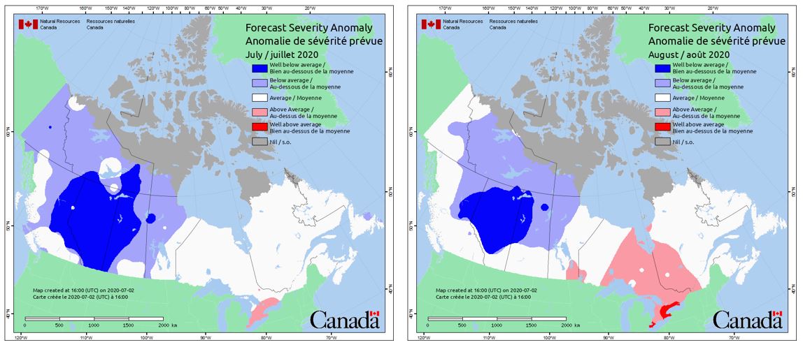
Wildfire Forecast Severity Anomaly, July (left) and August (right) 2020 (CWFIS)