

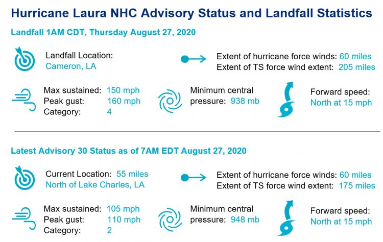
Hurricane Laura made landfall last night over southwest Louisiana with destructive winds, storm surge and heavy rainfall.
- Maximum sustained winds at landfall were 150 mph according to the National Hurricane Center (NHC), a significant category-4 hurricane . The center of circulation moved inland near Cameron, Louisiana around 2 AM EDT.
- Laura is now a category-2 hurricane over central Louisiana and is anticipated to weaken to a tropical storm over Arkansas this afternoon..
- Laura should weaken further to tropical depression status as it moves into the central Mississippi Valley for tomorrow. Laura should then clear the mainland US over the Mid-Atlantic this weekend and perhaps gain strength as it interacts with another frontal system over the western Atlantic.
- Ongoing hazards include hurricane conditions and destructive winds, along with residual storm surge and heavy rainfall. A notable tornado threat also remains. Initial reports indicate evidence of considerable wind damage for areas near the core of the storm and adjacent to the coast. A significant storm surge has caused seawater inundation for areas along the coast and adjacent waterways, extending well inland from the immediate coast. Heavy rainfall has caused some freshwater flooding. It is too early to determine the scope and severity of impacts as the hurricane continues to move inland and damage assessment efforts begin. Hazards should gradually diminish as the storm continues to move inland and weaken.
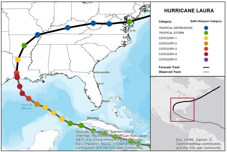
Hurricane Laura track and forecast through the weekend. Source: NHC/NOAA.
Meteorological Discussion
Hurricane Laura rapidly intensified throughout the day on Wednesday to a very strong category-4 hurricane; just 7 mph shy of a category-5. The rapid intensification prior to landfall was reminiscent of recent Gulf storms Harvey (2017) and Michael (2018). Overall, the storm’s wind speeds increased 65 mph in the 24 hours before landfall. At the time of landfall, Laura had gained the appearance of a perfectly symmetrical hurricane with a clear eye and spiraling thunderstorm bands extending for 100 miles (see below).
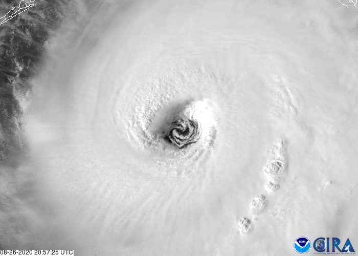
Satellite (visible) loop of the eye of Hurricane Laura just prior to darkness and landfall. Source: CIRA RAMMB
Laura came onshore with an intense band of heavy thunderstorms and strong winds on the northern periphery of the eyewall. This intense eyewall came onshore in Cameron, LA, while additional significant thunderstorm activity was occurring in the spiral rainbands, especially in the northeast quadrant of the storm at landfall. The eye remains remarkably intact inland, where winds are still at category-2 strength as of 8AM CDT, Thursday August 27.
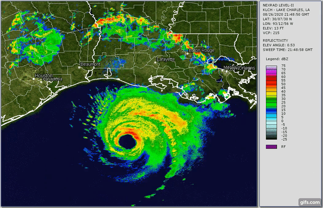
Texas-Louisiana regional Nexrad Radar Loop (26Aug 1300Z - 27Aug 0800Z). Source: Brian McNoldy, Univ. of Miami, Rosenstiel School
While estimates of wind and surge damage near the landfall point are emerging, the ongoing threat has now moved inland. Rainfall and associated flash flooding will be a major concern across several states in the days to come. Hourly rain totals as Laura moves inland are expected to be up to 3 inches/hour, with widespread accumulations of 4-7 inches today. There is some evidence that Laura may slow down briefly as it begins a shift in path toward the Mid-Atlantic. If this happens, localized rain totals could exceed 12 inches. Some of this precipitation may fall on already saturated soils or lingering flood waters from Marco which will only worsen the impact.
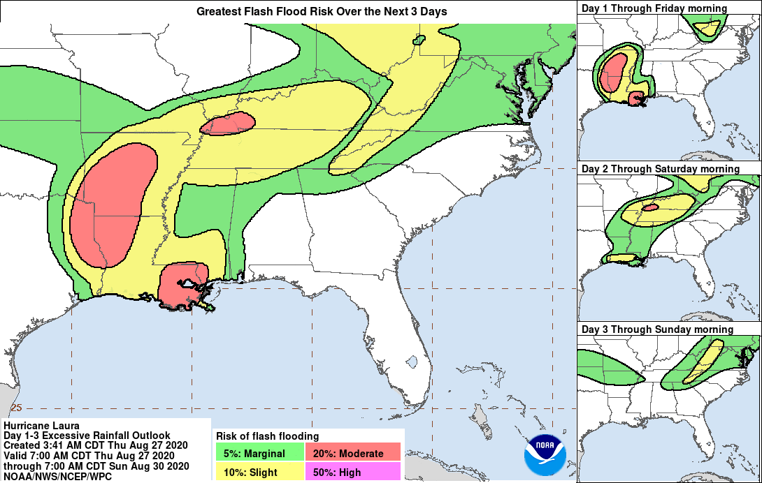
Flash Flooding Potential. Source: NHC [/caption]
Now that Laura has moved inland, it will rapidly weaken to a tropical storm later today and likely a depression by Friday. A gradual shift in track will take Laura on a path through the Ohio River Valley and Mid-Atlantic states, where heavy rainfall will continue to be a concern. It will likely re-emerge into the Atlantic Ocean, where there is some chance for a brief strengthening before transitioning into an extra-tropical cyclone off the waters of Maritime Canada.
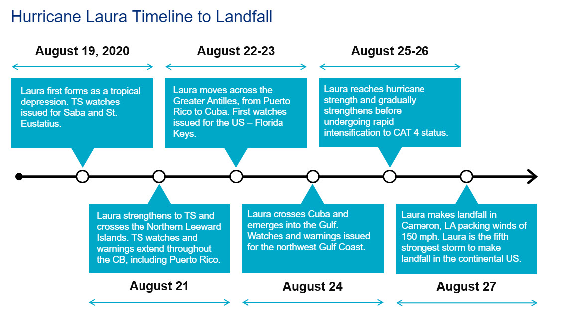
Key aspects of Hurricane Laura's development and progression until landfall. Source: Guy Carpenter / NHC.
Expert Discussion - The Numbers Behind the Historic Hurricane Laura Landfall
With a continental US landfalling hurricane as strong as Laura, and a season as active as 2020, a number of impressive statistics are noted with the landfall of Laura early Thursday morning. The majority of these continental US landfall statistics are compiled by hurricane seasonal specialist Dr. Phil Klotzbach of Colorado State University.
- 1: Ties the 1856 Last Island hurricane for the strongest Louisiana landfall on record
- 3: Number of landfalling hurricanes so far in 2020, tied with 1916 and exceeded by 1886 (5)
- 5: Laura ties as the fifth strongest hurricane to make continental US landfall
- 7: Number of named storms to make landfall by end of August, exceeding 6 landfalls in 1886 and 1916.
- 10: Number of landfalls with maximum sustained winds of 150 mph or higher since 1851.
- 65: Increase in maximum sustained winds in 24 hours (from 75 to 140 mph), fastest since Maria in 2017.
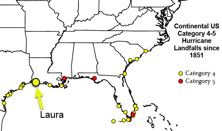
Continental US Category 4-5 Hurricane Landfalls since 1851. Source: Dr. Phil Klotzbach, Colorado State University.
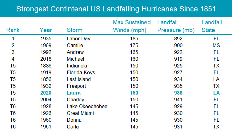
Strongest Continental US Landfalling Hurricanes Since 1851. Source: Dr. Phil Klotzbach, Colorado State University.
Storm Surge Impacts
NHC estimates before landfall placed peak storm surge from Laura between Johnson Bayou, Louisiana and the Rockefeller Wildlife Refuge with peak surge elevations reaching 15 to 20 feet and surge reaching up to 40 miles inland due in part to the surge generated on Sabine Lake and Lake Calcasieu. Some selected surge observations from NOAA water level sensors are below (these peak estimates are as of 7:30 CDT August 26 and may not represent the final peak surge at a location; all surge elevations are above NAVD88 datum):
- At Calcasieu Pass, Louisiana, just to the west of landfall and located at the entrance from the Gulf of Mexico to Calcasieu Lake surge elevation reached just under 10 feet at 1:00 AM CDT August 27.
- At Sabine Pass, Texas, further to the west of landfall and located at the entrance from the Gulf of Mexico to Sabine Lake surge elevation reached approximately 4.8 feet close to 3:30 AM CDT August 27.
- At the city of Lake Charles, Louisiana surge reached approximately 5.4 feet at 6:00 AM CDT August 27. This was preceded by a drawdown of water levels to approximate 1.2 feet below datum as Laura was approaching meaning water has risen nearly 7 feet since the onset of Laura’s winds.
- Along the Texas coastline surge reached 5.2 feet at the entrance to Galveston Bay at 5:45 AM August 27
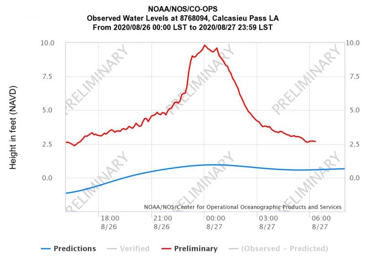
Observed water levels at Calcasieu Pass, LA. Source: NOAA/NOS.[/caption]
Updates and Useful Links
A CAT-i post-event report on Laura is scheduled for publication on Monday. Email alerts for Weather Sentinel and CAT-i reports are available on a subscription basis at the GC Preference Center here.
Daily, global tropical cyclone alerts are also available on a subscription basis here.
U.S. National Hurricane Center
Local Products Associated with Hurricane Laura
Official statements from the NHC and U.S. National Weather Service, and those of emergency management agencies supersede this update, and should be closely monitored concerning matters of personal safety.