

Excessively hot temperatures in recent days have created favorable conditions for the growth of numerous ongoing fires in the western United States as well as the ignition and spread of several new fires. A cold front has begun to bring cooler temperatures and precipitation in the form of both rain and snow to parts of the Mountain West but is also increasing wind speeds potentially mitigating precipitation effects. Much of California and the Pacific Northwest remain under Red Flag Warnings due to high temperatures and windy conditions.
Some notable ongoing fires include:
- The Creek Fire, burning in Fresno County, California, was ignited on September 4 and has burned 135,523 acres with 0 percent current containment. The fire has destroyed 65 structures according to the National Interagency Coordination Center (NICC). Extreme fire behavior has been observed for the Creek Fire largely driven by the fuels in the region. An estimated 80 to 90 percent of trees in the fire perimeter have been affected by beetle kill making fuels extremely susceptible to burning according to the National Wildfire Coordinating Group (NWCG). Numerous closures and evacuations are currently in effect, as the fire is still considered to be under initial attack for suppression.
- Elsewhere in California three fire complexes ignited by lightning storms in August currently exceed 350,000 acres each:
- The August Complex (356,312 acres) near Elk Creek, California was initially 37 different lightning ignited fires that eventually merged into three main fires. The fire is currently burning in chaparral, litter, and tall grass fuels and is 24 percent contained according the NWCG. The NICC estimates 10 structures have been destroyed by the fire.
- The LNU Complex (375,209 acres) located two miles north of Barro, CA is now 91 percent contained with minimal fire behavior according to NICC. 1,479 structures have been destroyed by the fire.
- The SCU Complex (396,624 acres) located five miles southwest of Brentwood, CA has destroyed 224 structures and is currently 94 percent contained according to NICC. Fire behavior is currently minimal although conditions today are expected to increase fire behavior according to CalFire.
- The Cameron Peak Fire, 15 miles southwest of Red Feather Lakes, CO, has reached 96,462 acres since its ignition on August 13 growing by 55,649 acres in the last day. The fire's location in remote and rugged terrain has limited suppression in recent days. Critically hot, dry and windy conditions created extreme fire behavior and the growth of the fire over the weekend although up to 14 inches of snow is expected in the region of the fire today limiting fire behavior with conditions later in the week expected to be conducive to enhanced suppression measures.
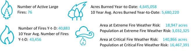
- Due to expected hot, dry, and windy conditions much of the west is at elevated fire weather risk today with the cities of Phoenix, AZ, Las Vegas, NV, Sacramento, CA, and Riverside, CA at critical fire weather risk and the cities of Portland, OR, Vancouver, WA, and Salem, OR at Extreme fire weather risk.
For September 8, 2020
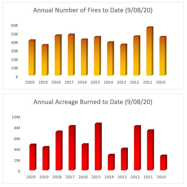
National Year to Date Number of Fires (top) and Acreage Burned (bottom) Source: Guy Carpenter and NIFC
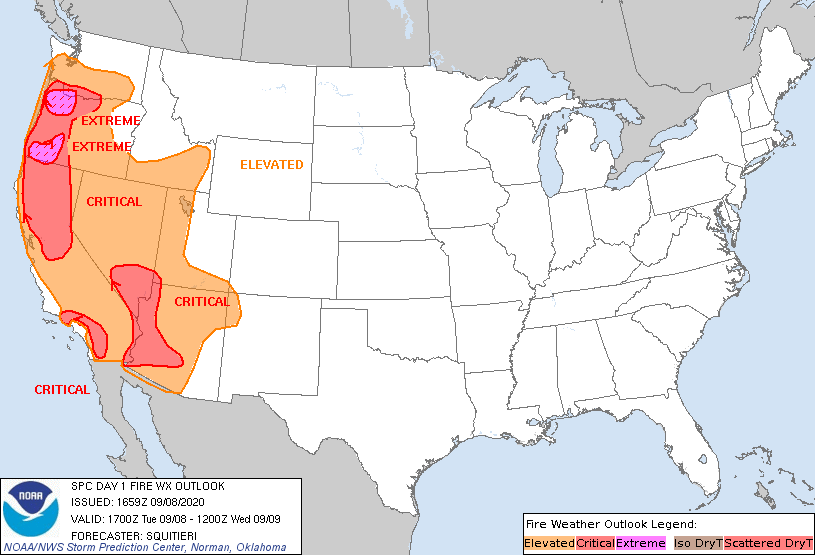
Day One Fire Weather Outlook Source: Storm Prediction Center
Meteorological Discussion
A confluence of excessive heat and lack of precipitation has led to a dangerous wildfire situation in much of the Western US. While many areas are typically dry this time of year, a weak southwest monsoon has exacerbated drought conditions across the four corners region. As of early September, 65% of the western US climate region is in a state of moderate to exceptional drought. The statistics may be deceiving, as nationally we are at 82% of normal acreage burned. In a typical year, nearly half of the national annual acreage burned is driven by wildland fires in Alaska. This year, however, was very quiet in terms of fire activity in Alaska, with the majority of activity concentrated in the Western US. Looking at California in isolation, the acreage burned as of August 31 was 500% of the historical 5-year average. In Colorado, the Pine Gulch Fire near Grand Junction is the largest fire in state history, with the Cameron Peak fire near Fort Collins as the 5th largest currently. The defining features of the 2020 season have been record heat and lack of precipitation. The moisture deficit is quantifiable by the 60-day percent of normal precipitation map below, where there are pockets of 5% of normal across much of the area where there is active fire activity. Fuels will dry out readily in this arid environment. First to dry are the 10-hour small fuels (less than 1 inch diameter), which are important for fire ignition. Observed 10-hour fuel moisture content is between 1-4% of normal over CA, AZ, UT, CO and NM. With a period of 30 to 60 day rainfall deficit, the large 3 to 8 inch diameter fuels will also have time to dry out. Observed 1000-hour fuel moisture content is less than 10% of normal across the entire western US. These 1000-hour fuels have the potential to sustain large and intense fires.
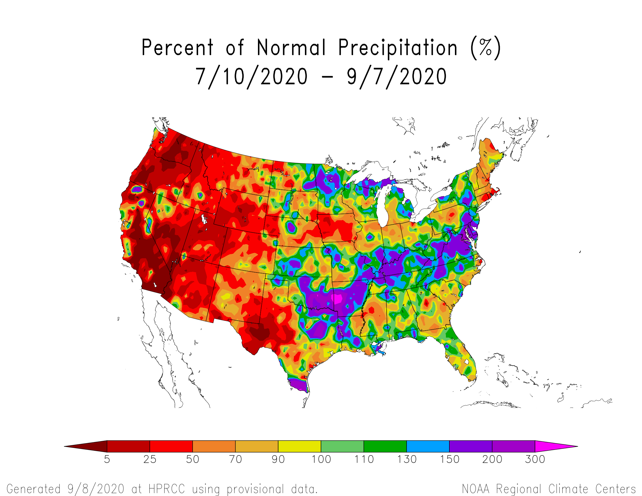
Observed 60 day precipitation percentage of normal Source: High Plains Regional Climate Center
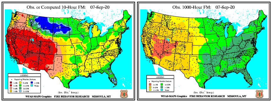
Observed 10-hour (left) and 1000-hour (right) fuel moisture percentage of normal Source: Wildland Fire Assessment System
Recent fire ignitions have resulted from a combination of human activity and a multi-day lightning event. The ignitions in areas of highly receptive fuels, in combination with some localized periods of strong wind, have resulted in dozens of fires exhibiting extreme fire behavior and rapid spread rates across several states. While the passage of a cold front and associated early season snow may help reduce the growth on several large Colorado fires, the situation in California remains critical. The on-set of seasonal offshore wind regimes, such as the Santa Ana winds, typically occurs in October. With the expectation of above average temperatures and below average precipitation, risk remains elevated.
September Significant Wildland Fire Potential Outlook
- Late August and early September have been characterized by excessive heat and little to no rain in the Western US, leading to dried out fuels that are extremely receptive to fire.
- A multi-day lightning event occurred over already primed fuels, which ignited several fires and led to a dramatic increase in fire activity over the past several weeks.
- Drought conditions are expected to persist over much of the west through September, with a gradual transition to fall conditions in the higher elevations by late in the month.
- Fall conditions include the return of precipitation with the passage of cold frontal boundaries; the combination of cooler temperatures and moisture should return the inter-mountain west to average significant wildland fire potential after months of above average outlook.
- By October, above average wildland fire potential will exist mainly in California’s coastal ranges and the Sierra Nevada, as seasonal winds resume and fuel conditions remain extremely dry.
- Fire activity in Canada is still well below average in terms of acreage burned (8% of normal), however fire danger rating remains high the southern Prairie Provinces as well as the Canadian Rocky region in Western Canada.
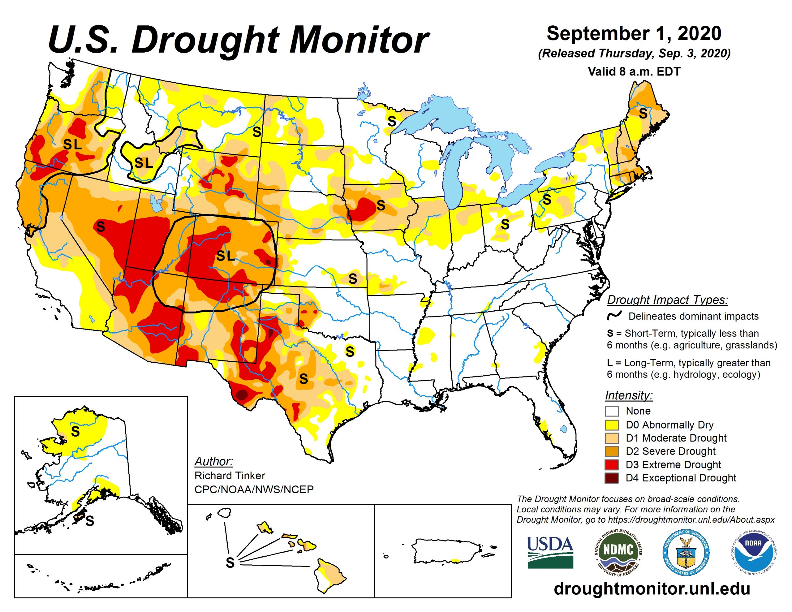
US Drought Monitor
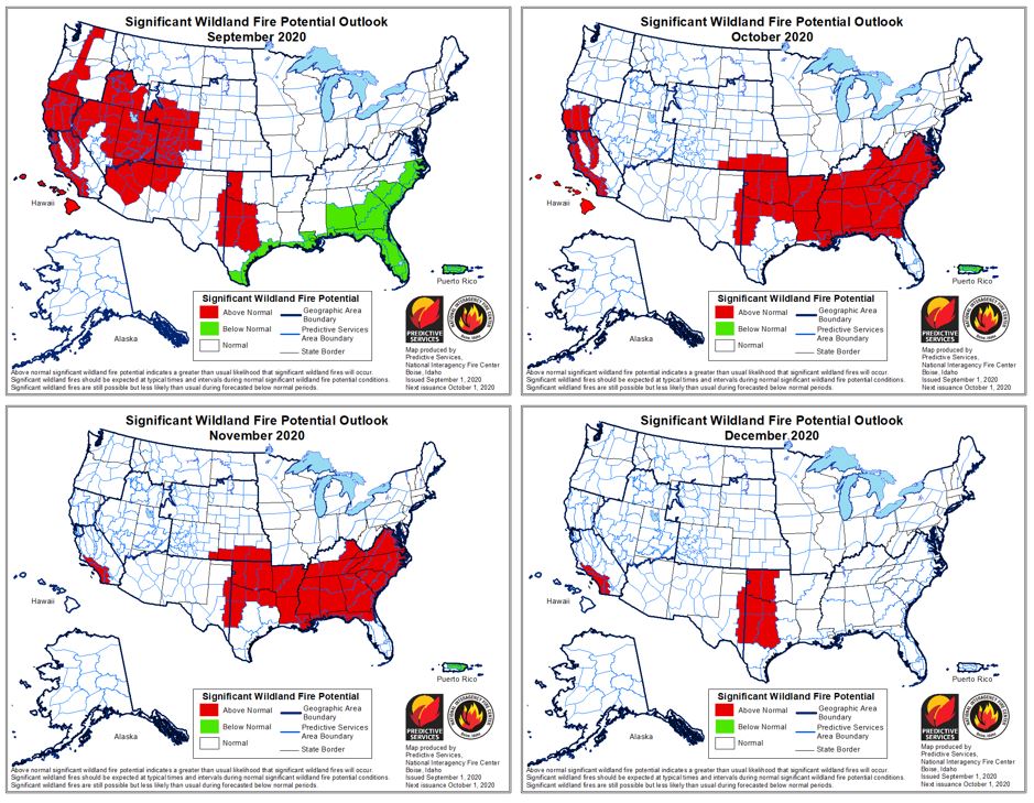
Significant Wildland Fire Potential Outlook Source: NIFC
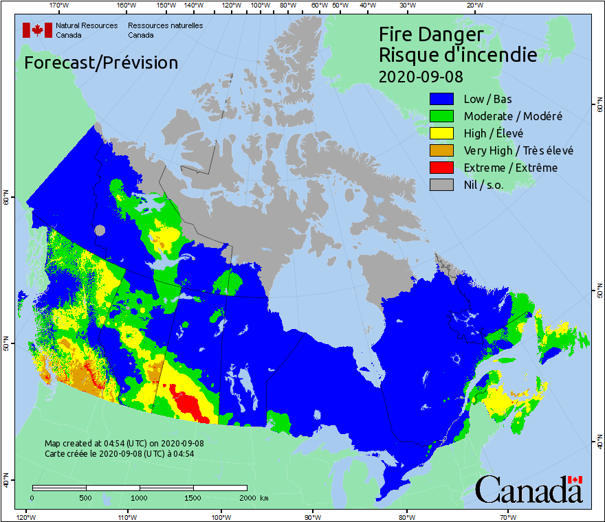
Canada Fire Danger Rating Source: CWIFS
Updates and Useful Links
GC Meteorologists and Wildfire Experts will continue to monitor the developing wildfire situation and post updates as necessary.
Email alerts for Weather Sentinel and CAT-i reports are available on a subscription basis at the GC Preference Center here.
California Department of Forestry and Fire Protection (CalFire)
National Wildfire Coordinating Group - Incident Information System
Official statements from emergency management agencies supersede this update, and should be closely monitored concerning matters of personal safety.