

Emerging off the coast of Cuba early Sunday afternoon, hurricane warnings have been issued for the Florida Keys, while a hurricane watch extends north to Naples on the west coast and Boca Raton on the east coast of Florida. Sustained winds up to 75 mph, gusting to 85 mph, are expected in the warning areas while those conditions are possible in the watch zone over the next 48 hours. Accompanying hurricane force winds, rainfall totals of 6-10" and storm surge up to 3 feet above mean high tide and isolated tornados are anticipated across portions of southern Florida. After clearing the Florida Keys, Eta looks to gain strength in the east-central Gulf of Mexico before a late week approach back towards the Gulf Coast of Florida.
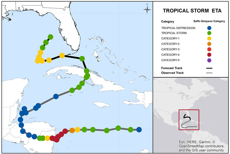
Progression and forecast of Tropical Storm Eta. Source: NHC
Key Headlines
- Short term forecast: Conditions over the next 24-36 hours are somewhat conducive for strengthening of Eta. Warmer than average sea surface temperatures and decreasing wind shear will promote some strengthening. Dry air to the south of Eta, along with recent land interaction over Cuba should limit rapid intensification of Eta. Timing of the turn to the west around a cutoff region of low pressure will determine how far north hurricane force wind gusts are possible on the Florida peninsula on Monday.
- Early week: After clearing the Florida Keys, conditions appear largely favorable for some intensification of Eta. Eta will slow down as steering currents weaken while the hurricane crosses the Loop Current in the southeast Gulf of Mexico. Recent model guidance is trending stronger with Eta through Tuesday, with the current NHC forecast of a category-1 hurricane through Tuesday. Higher intensities cannot be ruled out.
- Wednesday-Friday: Model guidance becomes more uncertain on the forecast beyond four days. The timing of the turn to the northeast, and a potential approach to the Florida Gulf Coast, along with the intensity, all are question marks today. The NOAA/NHC forecast would indicate a possible Friday landfall with Eta weakening towards the northern Gulf Coast of Florida. However, models show a meaningfully large range of outcomes. For intensity, a dissipating area of low pressure to a strong category-1 hurricane are projected. Landfall potential ranges from the Tampa metro region north to the Big Bend of Florida. Another cluster of models bring Eta close to the coast, and then move the storm back westward again into the Gulf of Mexico while weakening.
Historical Context
- If Eta remains a named storm until Saturday, it will become the longest lasting November tropical cyclone on record. Forming on October 30, it will eclipse the 1932 Cuba Hurricane and 1994 Gordon for a duration of 14 days.
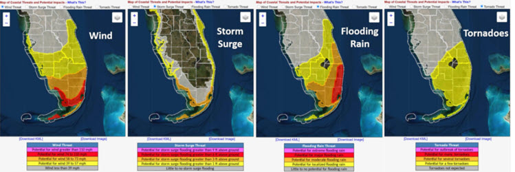
Region of key impacts and hazards associated with Eta in south Florida. Click on image to see detailed assessment through NWS/NOAA. Source: NHC/NOAA.
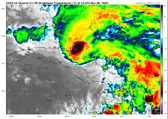
Infrared satellite of Tropical Storm Eta entering the Straits of Florida north of Cuba. Source: TropicalTidbits.
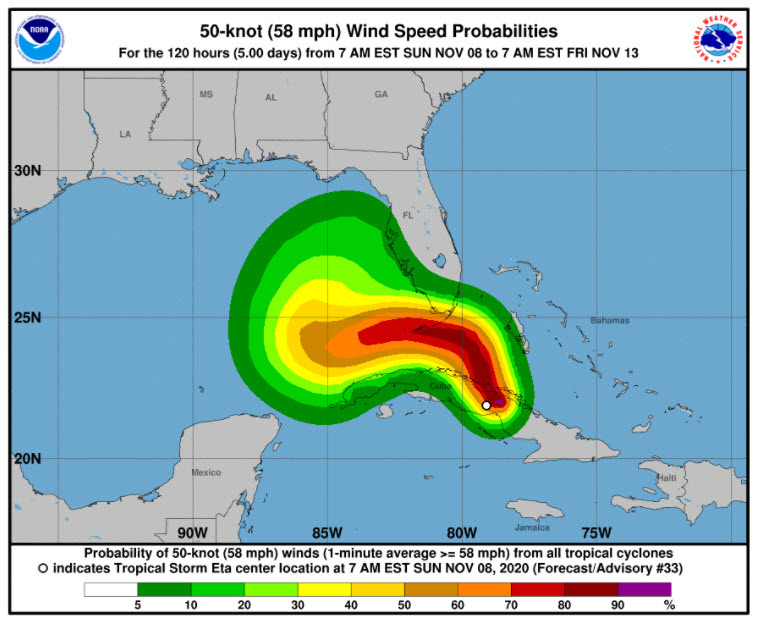
Five day forecast of 50-knot wind speed probabilities. The large range of outcomes by five days highlights the uncertainty in the longer range forecast. Source: NHC.[/caption] With the short range forecast relatively certain and larger uncertainty mid-week and beyond, the next update on Eta is planned for Tuesday, November 10th. Statements from official meteorological and emergency management agencies supersede this update, and should be closely followed concerning matters of personal safety.
Additional Links:
National Weather Service Offices:
Key West, Miami, Tampa Bay, Melbourne National Hurricane Center