

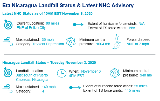
After making landfall Tuesday afternoon as a dangerous category-4 Hurricane in Nicaragua, Tropical Depression Eta is currently a 35 mph storm over warm waters off the coast of Belize. Catastrophic flooding is occurring in portions of Central America, with landslide potential in higher terrain.
Eta is expected to redevelop and begin a track to the northeast, possibly impacting the Cayman Islands, Jamaica, Cuba and Florida by early next week. Although the details of the intensity and track remain uncertain, it is likely that Eta will regain tropical storm strength and bring wind, rain and surge impacts to the Caribbean and Florida.
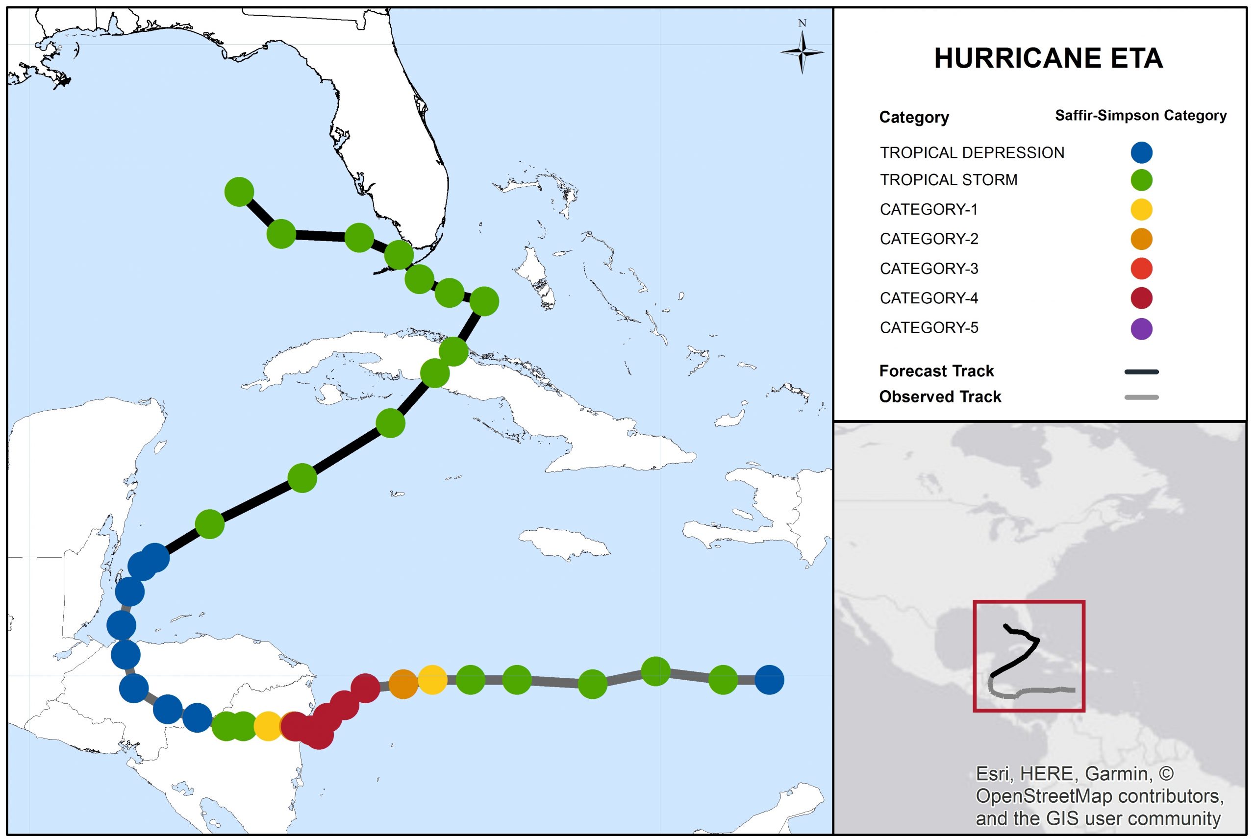
Hurricane Eta Track and Forecast. Source: NOAA/NHC.
Key Headlines
- Uncertainy in Track Forecast : Eta is drifting slowly to the north off the coast of Belize as of Friday morning, with a gradual turn and acceleration to the northwest expected today. The NHC official forecast brings Eta to the east of the Cayman Islands, before beginning a more northerly track around the north side of a cut off low. Various other ensemble models, such as the HWRF, continue Eta toward the Bahamas before a gradual turn to the north and eventually west around the low. The timing and exact location of where the northerly turn occurs has implications for the Bahamas, Florida and the Florida Keys in particular.
- Intensity: Forecast models are in fairly good agreement that Eta will quickly redevelop into a tropical storm later today, with peak winds of about 65 mph expected as it nears Cuba. Trough interactions as well as terrain induced weakening over Cuba are possible, and create some uncertainty around potential intensification to a hurricane near Florida.
- Hazards: The wind field of Eta is expected to expand as the storm nears Cuba, bringing widespread impacts to the island by Sunday. This expansive wind field also has the potential to impact South Florida by early in the week. Rainfall and associated flooding will be a concern, especially over the mountainous terrain of Cuba.
- Historical Context: The most recent November landfalling tropical storm in Florida was Tropical Storm Mitch in 1998, which incidentally also impacted Nicaragua as a major hurricane. The most recent November landfalling Hurricane in Florida was Hurricane Kate (1985).
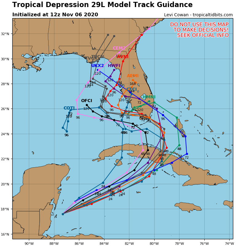
Model track guidance for Eta, highlighting the high degree of uncertainty. Source: Tropical Tidbits.
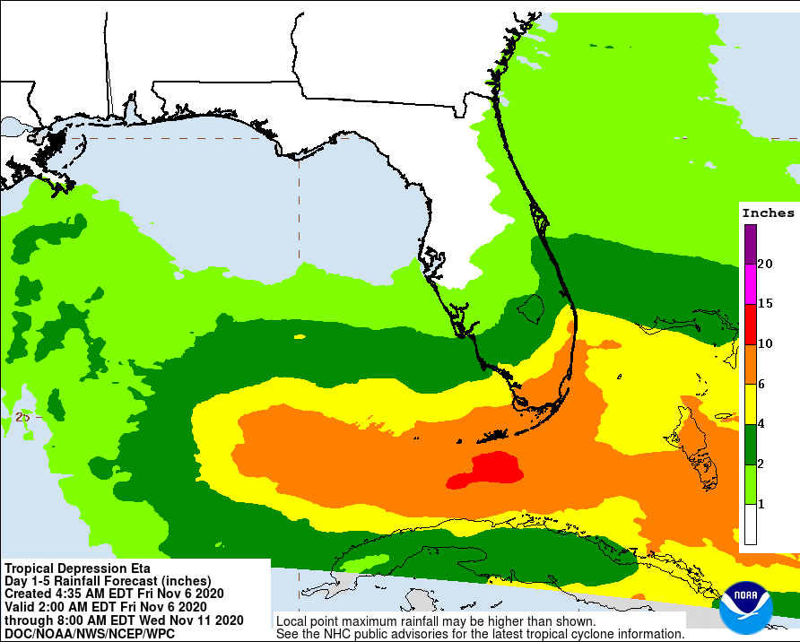
72-Hour Rainfall Forecast Ending 8AM EDT Wednesday, November 11. Source: NOAA/WPC.
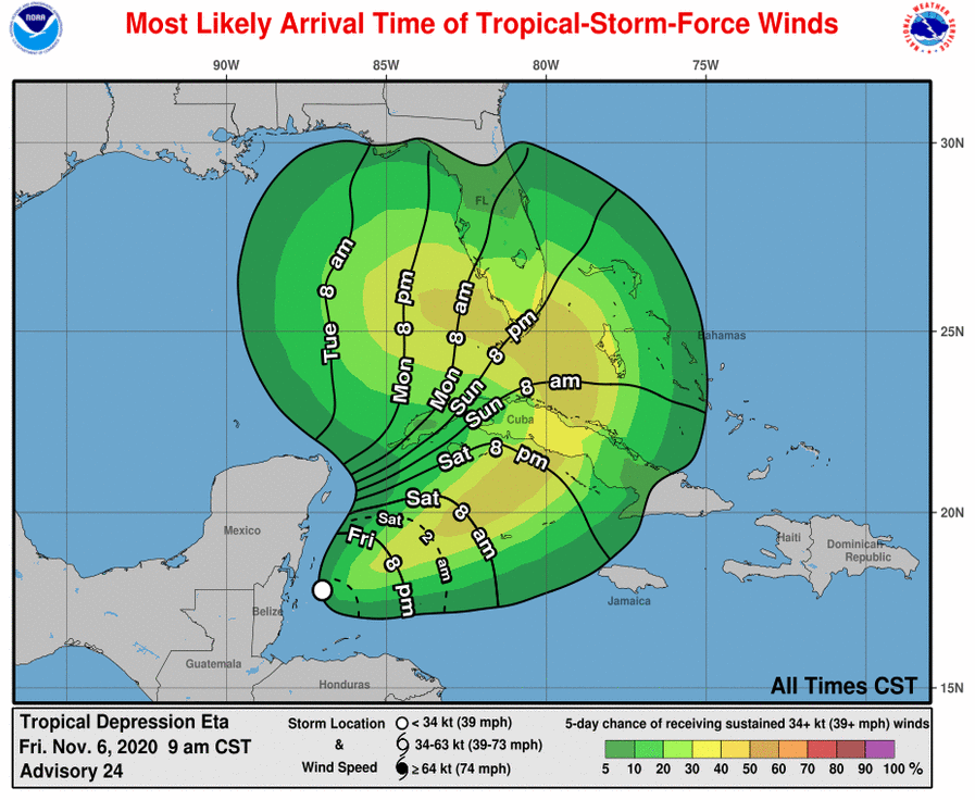
Most Likely Arrival Time (lines) and Probability (shaded) of Tropical-Storm-Force Winds. Source: NOAA/NHC.
Central America Discussion
- Physical Discussion: Hurricane Eta made landfall just south of Puerto Cabezas, Nicaragua as a strong category-4 hurricane Tuesday afternoon. Prior to landfall, the storm crawled offshore for hours before finally moving inland. It had reached peak strength as a 150 mph category-4 hurricane, after a period of rapid intensification from 70 mph to 150 mph over a period of 24 hours. The storm weakened slightly prior to landfall during an eyewall replacement cycle (where a new eyewall develops around the center of circulation, the old eyewall expands outward, and the wind footprint expands with a slight reduction of wind speed).
- Post-Landfall: Following landfall, the storm weakened to tropical storm status within twelve hours, and then to a tropical depression within 24 hours. However, Eta continued to bring excessive rainfall amounts, in some cases well in excess of 30 inches, to affected areas of Central America. Flood impacts have been quite severe for areas including Honduras, Guatemala and Nicaragua.
- Wind Impacts: According to initial media reports, wind impacts were especially severe around the area where the core moved ashore, with evidence of severe to complete damage to affected properties and infrastructure, along with uprooted trees.
- Flood Impacts: Extensive and severe flooding with mudslides has been reported across portions of Nicaragua, Guatemala and Honduras. Several hundreds of homes have been washed away, buried or otherwise destroyed, and this number could well change as post-storm assessment efforts move ahead. High water rescues have been ongoing. At least 50 fatalities have been reported by media.
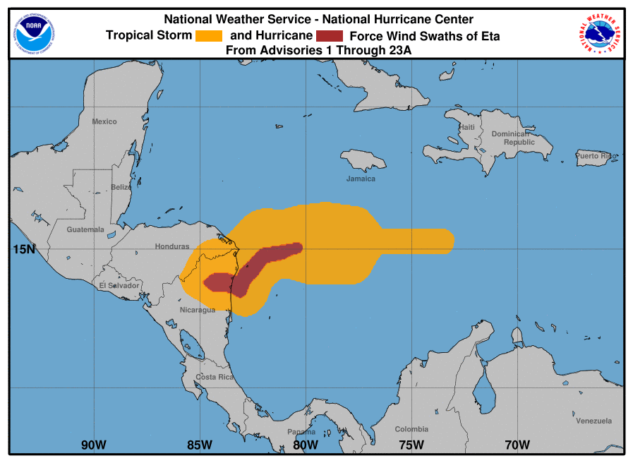
Hurricane (red) and Tropical Storm (orange) force wind history for Eta. Source: NOAA/NHC.
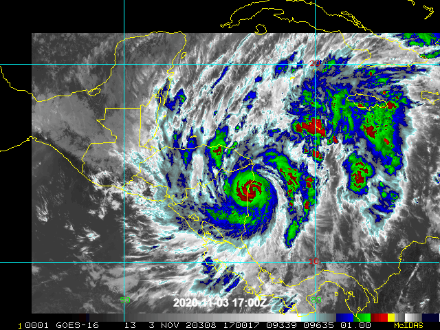
Satellite (infrared band) imagery of Hurricane Eta as it makes Nicaragua landfall. Source: NOAA/NESDIS.
Guy Carpenter meteorologists will resume Weather Sentinel statements for Eta if it poses a material and escalating threat for landfall as a hurricane. Statements from official meteorological and emergency management agencies supersede this update, and should be closely followed concerning matters of personal safety.
Email alerts for Weather Sentinel and CAT-i reports are available on a subscription basis at the GC
Preference Center here.
Daily, global tropical cyclone alerts are also available on a subscription basis here.
U.S. National Hurricane Center