

Key Headlines
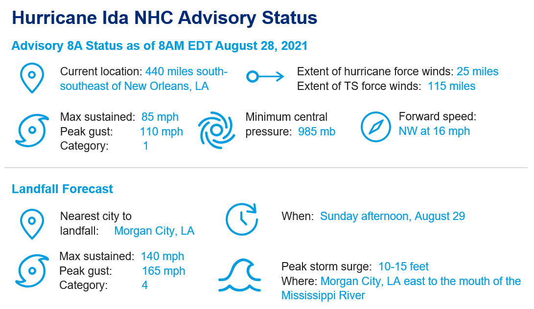
- Escalating Threat: Hurricane Ida is now expected by the National Hurricane Center (NHC) to make landfall over southeast Louisiana as a category-4 hurricane, with maximum sustained winds prior to landfall of 140 mph. Forecast storm surge is now in the range of 10-15 feet.
- Significant Strengthening Expected: After landfall over Cuba, Ida has since emerged into the Gulf of Mexico over warm waters, and in a moist environment with reduced wind shear. Rapid intensification is probable according to the NHC.
- Expected Impacts: Downed trees, powerlines and variable property damage along with flood issues are a concern from Louisiana to Alabama. The most destructive effects are expected over southeast Louisiana with severe hurricane winds, a significant storm surge and heavy rainfall.

Satellite imagery (infrared) of Hurricane Ida. Source: TropicalTidbits.
Summary
- Rapid Intensification: As Hurricane Ida crosses the Gulf of Mexico it will move over very warm waters that extend to some depth, with an environment of reduced wind shear and abundant moisture. These conditions are expected by the NHC to allow a period of rapid intensification, defined as a 35 mph gain in maximum sustained winds over a 24 hour period. Weather models typically struggle with these cases. Accounting for these factors, the NHC best forecast is for Ida to gain strength rapidly, with maximum sustained winds of 140 mph just prior to landfall Sunday afternoon.
- Forecast: Hurricane Ida is expected by the NHC to take a track to the northwest through Sunday afternoon, before turning to the north-northwest just prior to landfall over southeast Louisiana the same day. Factors in play include a disturbance over the western Gulf, and the edge of the Bermuda High to the northeast. Model guidance is in close agreement on the expected track, which is uncommon. Following landfall, Ida should weaken and turn to the north and northeast into the Lower Mississippi and Tennessee Valley for early next week.
- Hazards:
- Destructive Winds: Tropical storm force winds will render downed trees and powerlines with variable property damage from Louisiana to Alabama and extending well inland. More destructive effects with hurricane wind conditions can be expected in the Atchafalaya Basin and southeast Louisiana. The most severe effects will be along and to the right of the track and near the coast, where severe to complete damage to property and infrastructure is possible.
- Storm Surge: Storm surge will affect areas along the coast and connected waterways from Louisiana to Alabama, with most significant levels of 10-15 feet from Morgan City to the Mouth of the Mississippi River. A storm surge of 4-7 feet is also probable for Lake Pontchartrain. The storm surge will also be accompanied by large and destructive waves. Extensive seawater inundation can be expected as a result for the affected coast and connected waterways, with resulting destructive effects to both property and infrastructure.
- Heavy Rainfall: Heavy rainfall amounts of 8-16 inches are expected by the NHC, with isolated higher amounts to 20 inches. This heavy rainfall will bring the threat of flooding and flash-flooding to affected areas. Stormwater management systems may be overwhelmed, especially when drainage is impeded by storm surge.
- Hurricane, storm surge, and tropical storm warnings are now active for areas under threat. Specifics can be found at www.weather.gov.
- Flood Implications: The combined effects of heavy rainfall and storm surge will bring destructive flood effects to coastal areas but also areas well inland. NFIP take-up rates are variable by county in Louisiana, with highest penetration for coastal areas.
- Historical Significance: It is notable that Hurricane Ida will make landfall as a severe hurricane on August 29, the same date that Hurricane Katrina made landfall near the Pearl River in 2005. While no two hurricanes are the same, and each have their own unique effects, the forecast track of Hurricane Ida is remarkably similar to that of Hurricane Betsy (1965). Betsy also made landfall as a category-4 hurricane, with historic impacts due to both storm surge and wind.
[caption id="attachment_55514" align="aligncenter" width="760"]
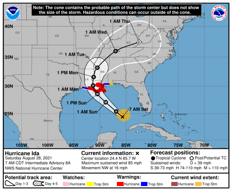
Position and best forecast with watches/warnings and official cone of uncertainty. Source: NOAA/NHC.[/caption]
[caption id="attachment_55515" align="aligncenter" width="760"]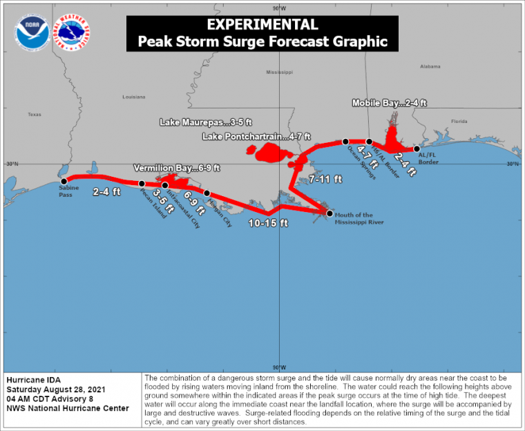
Forecast peak storm surge. Source: NOAA/NHC.[/caption]
[caption id="attachment_55516" align="aligncenter" width="760"]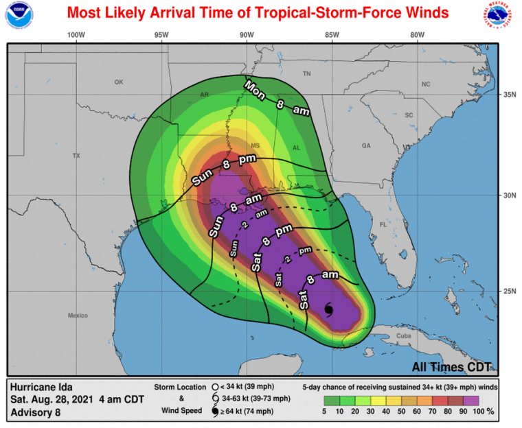
Most likely onset (lines) and probability (shaded) of tropical storm force sustained winds. Source: NOAA/NHC.[/caption]
[caption id="attachment_55517" align="aligncenter" width="760"]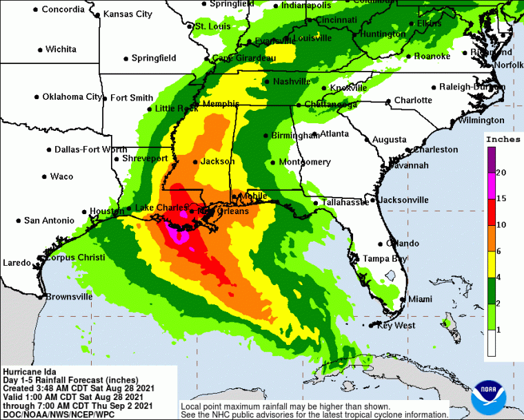
Forecast 5-day rainfall amounts ending 8AM EDT September 2. Source: NOAA/ WPC.[/caption]
[caption id="attachment_55518" align="aligncenter" width="548"]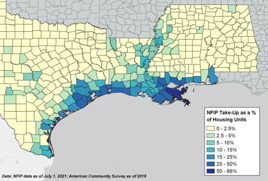
NFIP take-up rates for the Northern Gulf States. Source: FEMA.[/caption]
[caption id="attachment_55519" align="aligncenter" width="1040"]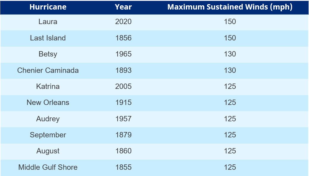
Strongest hurricanes to make landfall in Louisiana since the 1850s. Source: NOAA/AOML.[/caption]
Additional links of interest:
U.S. National Hurricane Center
Local Products Associated with Tropical Storm Ida
Statements from official forecast and emergency management agencies supersede this update, and should be closely followed concerning matters of personal safety.