

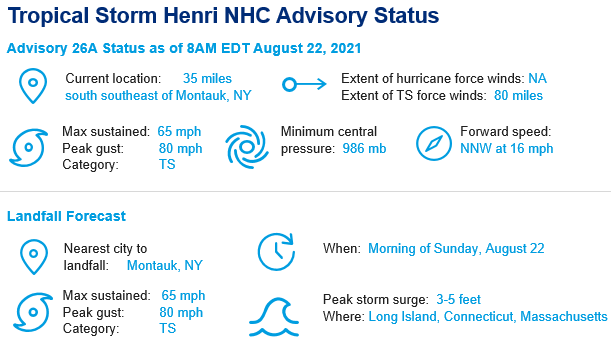
Key Headlines
- The forecast is unchanged: Henri is a high end tropical storm with landfall expected midday Sunday on far eastern Long Island and then subsequently tracking close to the Connecticut / Rhode Island border. A full discussion of the forecast can be read in our Friday August 20 update, while today's update focuses on the major perils at risk with the landfall of Henri.
- Next 48 hours: After landfall today, Henri will slowly track across southern New England tomorrow before dissipating on Tuesday as a remnant low pressure system. Inland flooding associated with heavy rainfall is the highest concern post landfall.
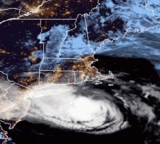
Latest satellite animation of Henri's approach to the New England coastline. Click the image to view real-time satellite imagery through NOAA. Source: NOAA/NESDIS.
Storm Surge
- Storm Surge: Storm surge, combined with the tide, remains a significant threat to coastal areas from the Delmarva Peninsula to Massachusetts. Based on the current track and intensity forecast, the National Hurricane Center is forecasting 3 to 5 feet of storm surge from Long Island Sound to Narragansett Bay to Buzzards Bay where Storm Surge Warnings are in effect.
- Impact of Coastal Geography: Surge amounts can vary greatly over very short distances due to the complex coastal geography of the region. The largest surge will likely occur near and to the right of the ultimate landfall location. The Maximum Envelope of Water (MEOW) product produced by the National Hurricane Center is a good indicator of above ground flood levels for the region most significantly impacted by Henri. For a category 1 hurricane the MEOW projections highlighted below indicates that above ground flooding could be even more significant in immediately impacted areas. Real time storm surge assessment for various coastal tide gauges can be monitored via NOAA.
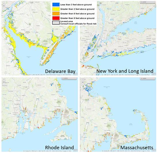
Maximum envelope of water (MEOW) product indicating potential maximum storm surge heights for a category-1 landfalling hurricane. Source: National Hurricane Center.
Inland Rainfall
- Widespread flash flooding and water rescues ongoing: Ahead of Henri's official landfall today, outer bands of the storm circulation have already brought widespread flooding to southern New England and the Mid-Atlantic. New York City broke a daily record on Saturday with 4.45". More impressive, 1.94" fell in one hour, the heaviest one hour rainfall total on record. Multiple subway stations being inundated by water runoff have been reported. This feeder band has moved south resulting in additional reports of significant flooding in central New Jersey overnight.
- Continued heavy rainfall next 48 hours: Inland flooding will continue to be a major headline with Henri as another 3-5" with isolated heavier totals are expected across New Jersey, New York and southern New England. The National Weather Service has issued a moderate risk of flash flooding associated with Henri's landfall.
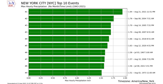
New York City 1-hour rainfall total of 1.94" was the highest hourly rainfall total in city history, breaking the prior record from September 2004. Source: Iowa Mesonet.
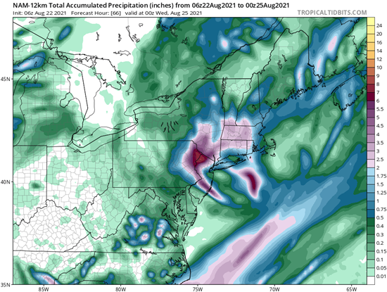
60 hour rainfall forecast from the NAM weather model through Tuesday evening. Source: National Hurricane Center.
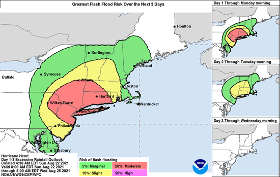
Flash flooding risk assessment with heighted concern across the greater New York City metropolitan region. Source: National Weather Service.
Wind and Power Outage Assessment
- Near record wet summer will increase tree fall losses and power outages: As Henri makes landfall, wind gusts of up to 70 mph will cause widespread power outages. Already, there are reports from energy providers of up to 10,000 customers without power in the Tri-State area. This region has received much above average rainfall in the months of July and August, making treefall and downed powerlines a major concern for a large area affected by winds from Henri.
- Power restoration expectations: Eversource, a major energy provider in New England, expects that 60-70% of its customers in Connecticut will lose power, some for an extended period of time (8-21 days for full restoration).
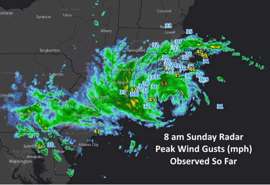
8AM Sunday August 22 radar and peak wind gust (mph) assessment for Henri. Source: NOAA Eastern Region.
Additional links of interest:
The next update on Tropical Storm Henri is anticipated Monday August 23, discussing the ongoing impacts and threats across southern New England.