

Key Headlines
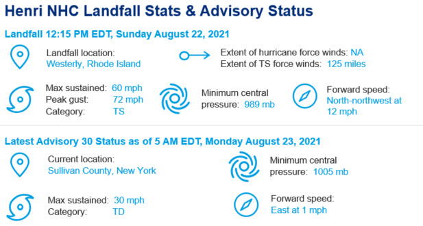
- Landfall Recap: Henri made landfall as a tropical storm early Sunday afternoon, August 22. Landfall occurred along the western Rhode Island coastline, near Westerly, with maximum sustained winds of 60 mph and higher gusts.
- Slow Moving: The center of Henri is currently located over New York's Hudson Valley and is nearly stationary in movement. Henri is expected to slowly regain forward speed later today and trek east, moving offshore by Tuesday before dissipating.
- Continued Rainfall: Locally heavy rainfall on the order of 1-3 inches is expected over portions of Long Island, New England, southeast New York, New Jersey, and eastern Pennsylvania today. Flood watches are in effect throughout much of these areas as flash flooding remains a threat.
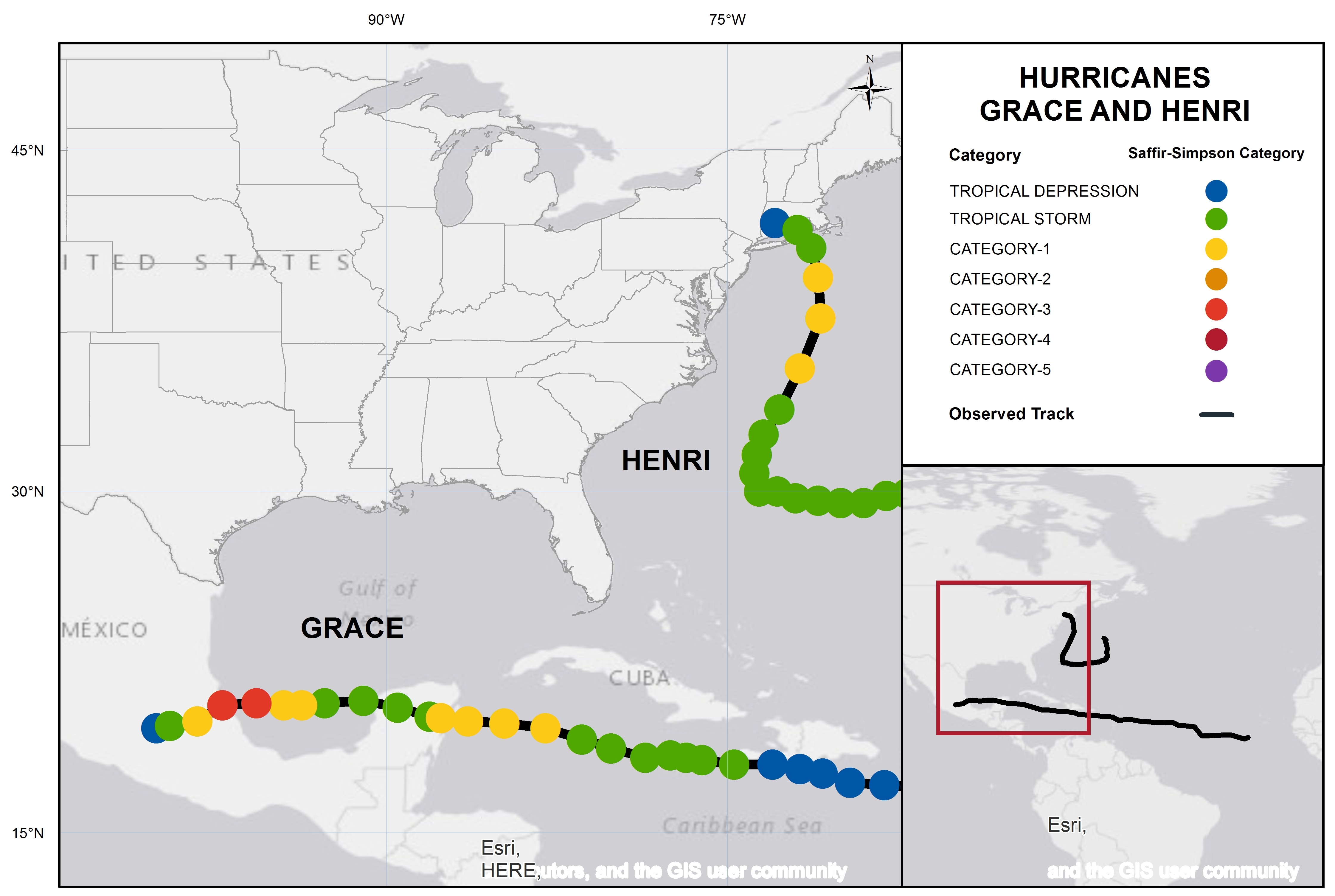
Track and position reports for Hurricanes Grace and Henri. Source: NOAA/NHC.
Henri Impacts
- Flooding from Inland Rainfall: Nearly 9 inches of rain fell in parts of central New Jersey, leading to severe flooding and a number of evacuations and water rescues. Street flooding was observed throughout parts of New Jersey and around the New York City Metro. Additional details on rainfall, including the record-setting one-hour rainfall that occurred in Central Park, can be found in our Sunday August 22 update.
- Wind Damage and Power Outages: Multiple gusts in excess of 60 mph were observed off the coast of Long Island and Rhode Island. Downed trees and powerlines were reported across Rhode Island, Connecticut, Massachusetts, New York and New Jersey, compounded by the effects of above average rainfall over the last few months. Power outages impacted over 100,000 customers on Sunday, mainly in Connecticut and Rhode Island, which is now down to an estimated 50,000 customers as of Monday morning.
- Storm Surge: Observed storm surge impacts from Henri were generally minimal, due to a number of factors: a shift east ahead of landfall, general weakening of the storm, and landfall timing not coinciding with high tides.
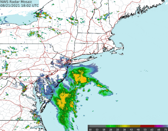
Radar loop of Henri beginning 2 PM EDT August 21, 2021. Click here to view animation. Source: Brian McNoldy, Univ. of Miami, Rosenstiel School.
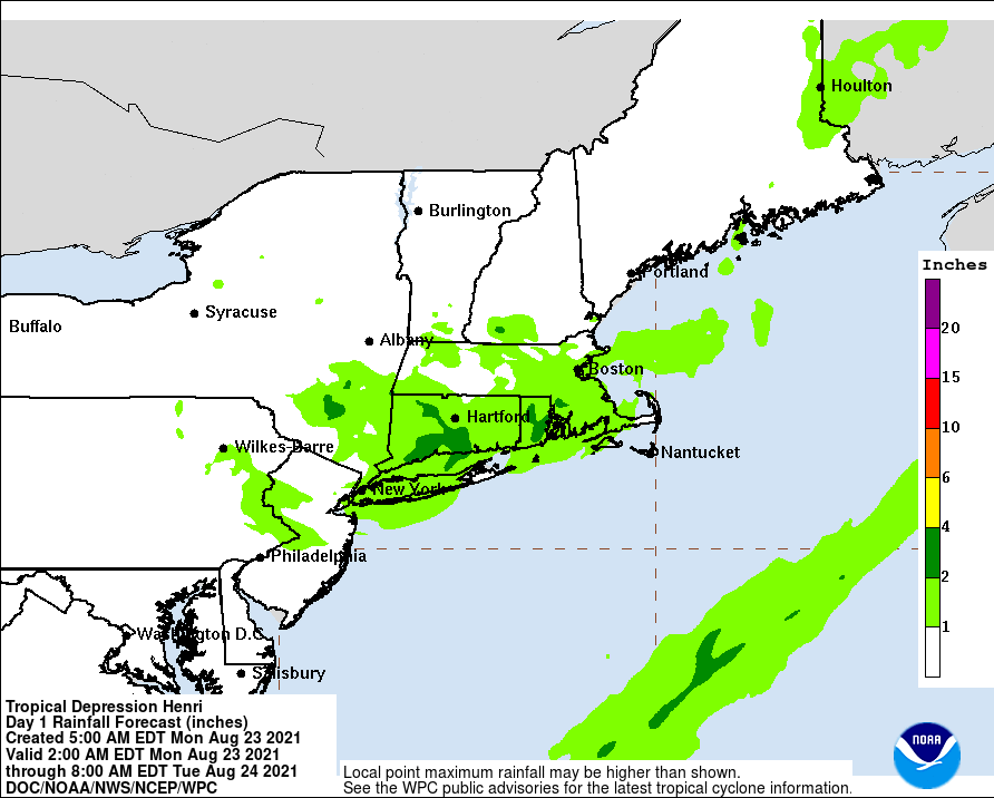
Additional rainfall forecast through 8 AM EDT August 24, 2021. Source: NWS/NOAA.
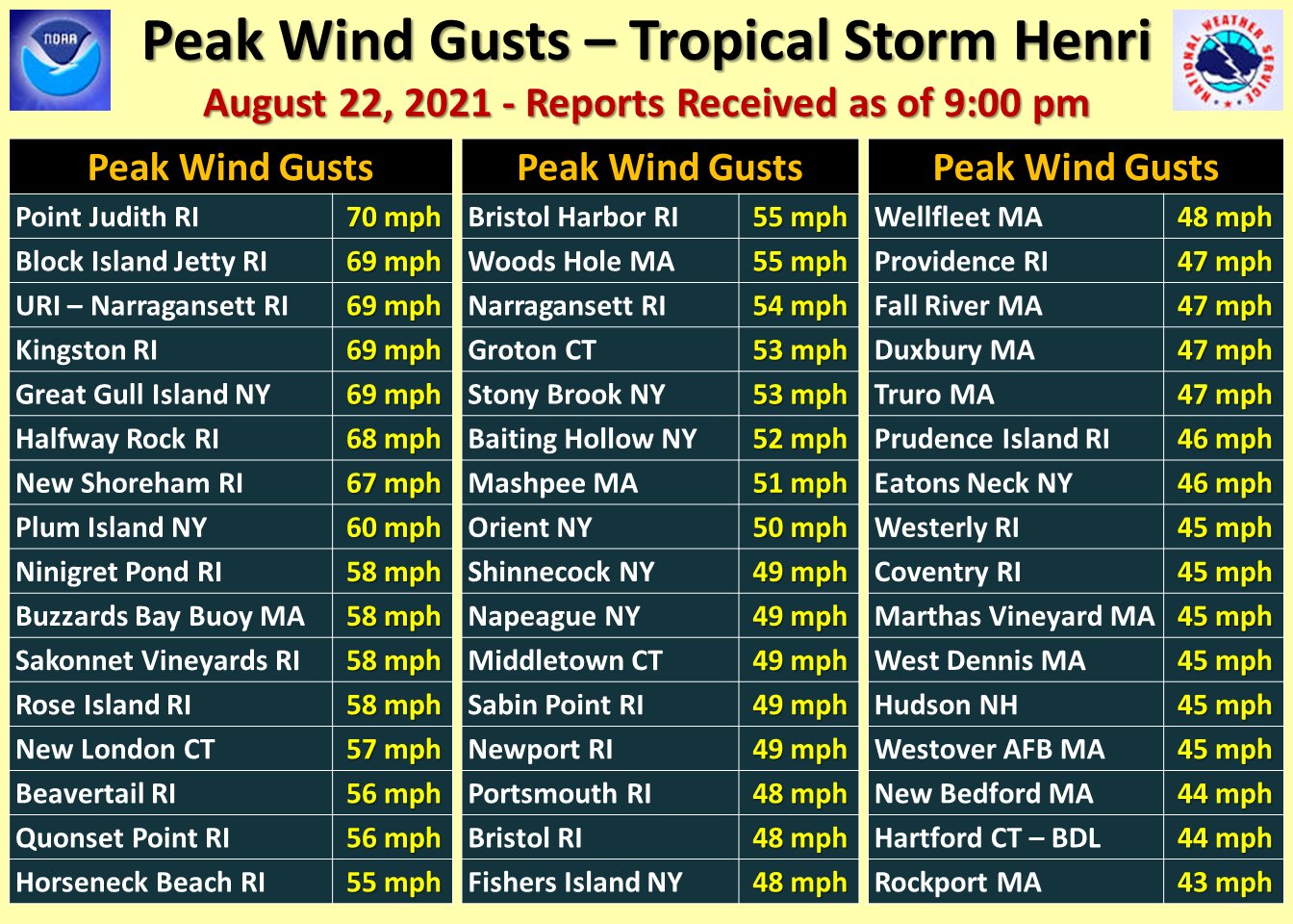
Peak wind gusts associated with Henri as of 9 PM EDT August 22, 2021. Source: NWS Eastern Region.
Hurricane Grace Update
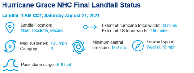
- After a period of rapid intensification, Hurricane Grace made its final landfall as a major hurricane early Saturday morning, near Tecolutla, Mexico.
- Hurricane winds causing downed trees and powerlines, along with variable property damage were of concern, with most destructive effects along and to the right of the core of the storm.
- A storm surge of 6-9 feet was expected by the NHC, along with wave battering to affect coastal areas and adjacent waterways.
- As Grace moved inland, it was downgraded by the NHC to tropical storm status at 10 AM CDT August 21, before dissipating by 4 PM CDT over the terrain of Mexico.
- Heavy rainfall with flash flooding and mudslides were a concern during the period, including for the Mexico City area.

Hurricane Grace satellite image. Source: CSU/NOAA/NESDIS.[/caption]
Additional links of interest:
NOAA Coastal Inundation Dashboard for Henri
USGS Coastal and Inland Flood Event Viewer
U.S. National Hurricane Center
Local Products Associated with Tropical Storm Henry
This will be the last update on Tropical Storm Henri and Hurricane Grace, unless they possess a renewed threat for hurricane impacts to the Americas.