Key Headlines
- 9th Named Storm: Ida's formation yesterday, August 26, marks the ninth named storm of the 2021 Atlantic Hurricane Season. Ida formed nearly a month ahead of the average date of formation for "I" storms, September 26, based on the 1953-2020 average.
- Significant Strengthening Expected: As Ida crosses Cuba and enters into the Gulf of Mexico this weekend, favorable conditions will enable steady to rapid strengthening. The NHC forecast currently calls for a peak intensity at major hurricane status before landfall on the Northern Gulf Coast. Rapid intensification is a growing possibility, as Ida moves over the Gulf of Mexico and encounters above average sea-surface temperatures.
- Caribbean Impacts: Ida crossed the Cayman Islands overnight as a weak tropical storm and is now approaching Cuba. Tropical Storm warnings are in effect for the western portion of the island as strong winds, heavy rainfall, and storm surge of 2-4 feet can be expected through tonight.
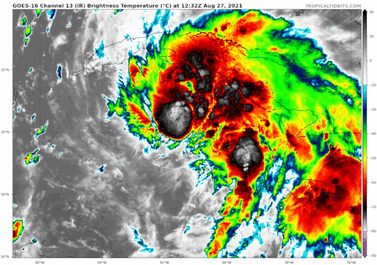 Satellite loop of Ida over the past 3 hours. Source: Tropical Tidbits.
US Impacts
- Landfall: Following a northwesterly track through the Gulf of Mexico this weekend, the current NHC forecast is for landfall along the Louisiana coastline late Sunday or early Monday. Louisiana saw four named storms make landfall along the coastline just last year.
- Hazards:
- Hurricane force winds, potentially those of major hurricane strength (>110 mph) are possible along the Northern Gulf Coast as early as overnight Saturday evening into Sunday morning. Winds of this strength can render significant damage to both property and infrastructure. Widespread power outages can be expected, in addition to snapped and uprooted trees. Damage will be most severe along and adjacent to the track, and lower-grade damage with power outages can also be expected well away from the center of circulation.
- Dangerous storm surge as high as 7-11 feet is possible along parts of the US Gulf Coast. The deepest water is expected to occur near and to the east of landfall, along the immediate coastline. Surge will be accompanied by large, destructive waves, and if coinciding with high tides, will be even more hazardous. Extensive seawater inundation can be expected for the affected coast and waterways, with resulting destructive effects to both property and infrastructure.
- Heavy rainfall capable of considerable flooding is likely from southeast Louisiana to coastal Mississippi and Alabama, where rainfall accumulations of 8 to 16 inches and local maximum of up to 20 inches are possible.
- COVID-19 implications: With confirmed cases near the highest levels in Louisiana since the beginning of the pandemic, additional concern exists around the potential need for hurricane shelters and individuals congregating within close proximity to others.
- High Confidence: While the average error in the 72-hour track from the NHC is 120 miles, weather models are in general agreement in terms of both track and intensity, increasing the forecast confidence. Nevertheless, the possibility of rapid intensification may not be fully resolved by model guidance, and will have to be monitored closely.
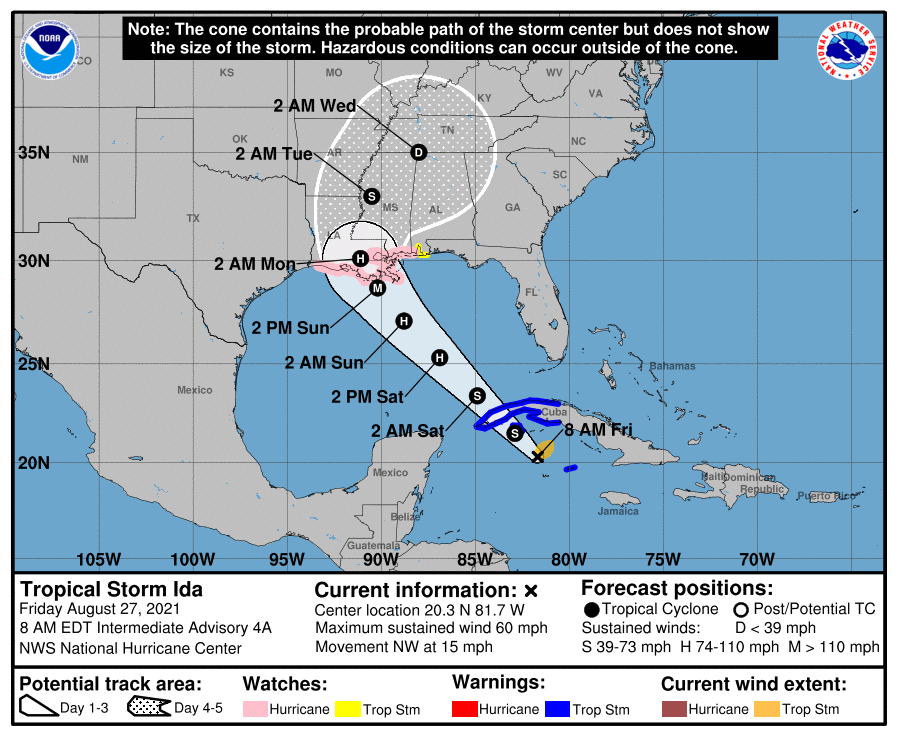 Position and best forecast, with official 5 day cone of uncertainty for Ida. Source: NOAA/NHC.
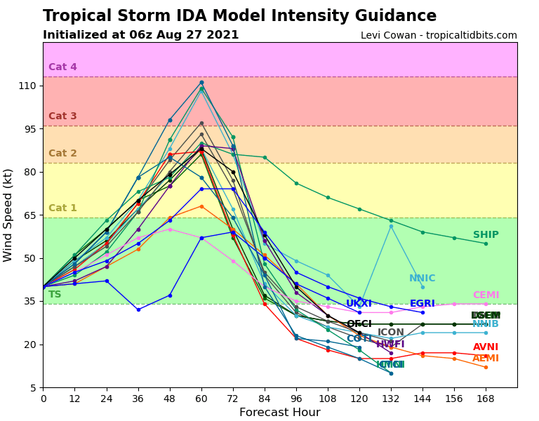 Weather model intensity guidance for Ida, indicating the potential for major hurricane status. Source: Tropical Tidbits.
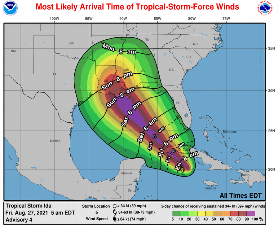 Most likely onset (lines) and probability (shaded) of tropical storm force sustained winds. Source: NOAA/NHC.
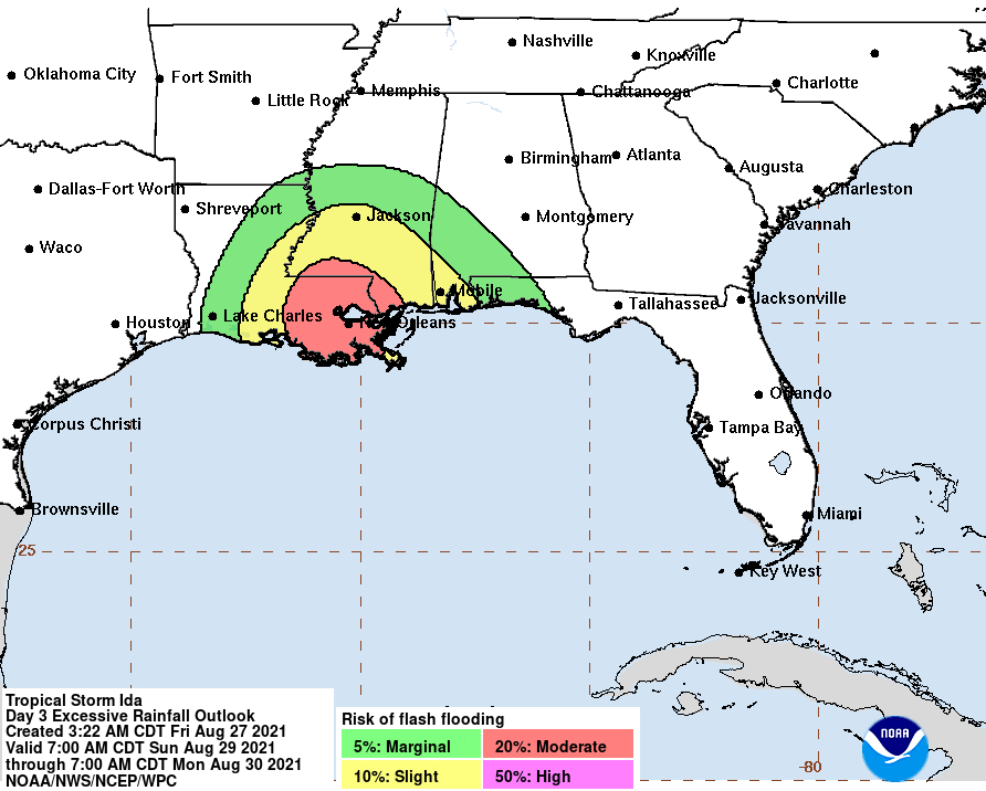 Flash Flooding potential along the US Gulf Coast associated with Ida. Source: NOAA/WPC.
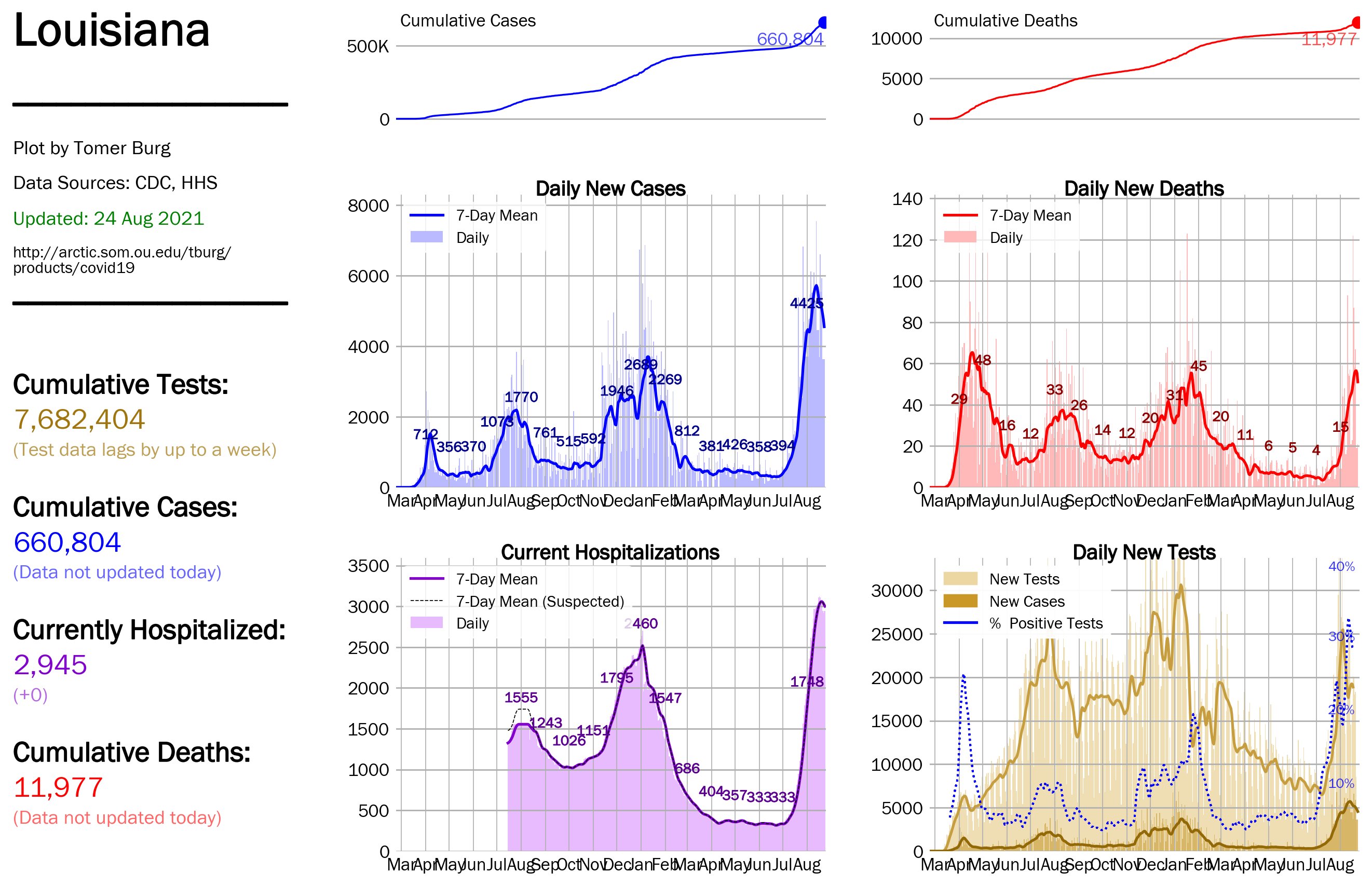 COVID-19 dashboard for the state of Louisiana, last updated August 24, 2021. Source: Tomer Burg, University of Oklahoma.
Additional links of interest:
NOAA Homepage for Ida
U.S. National Hurricane Center
Guy Carpenter meteorologists will continue to monitor Ida through the weekend. Further updates will be issued over the weekend if a materially different track or intensity forecast emerges. Statements from official forecast and emergency management agencies supersede this update, and should be closely followed concerning matters of personal safety.
|