
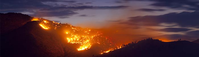
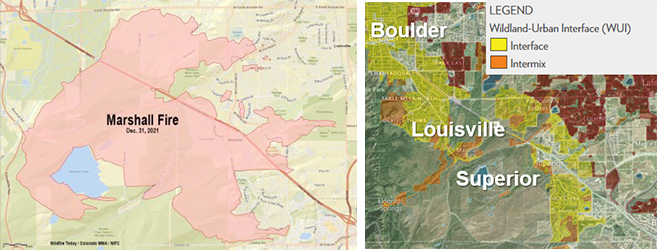
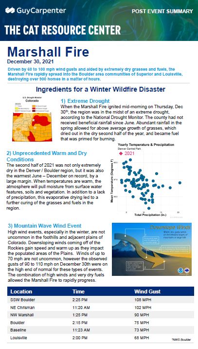
Driven by 60 to 100 mph wind gusts and aided by extremely dry grasses and fuels, the Marshall Fire rapidly spread into the Boulder area communities of Superior and Louisville, destroying 1091 homes in a matter of hours.
Ingredients for a Winter Wildfire Disaster
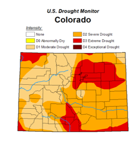
1) Extreme Drought
When the Marshall Fire ignited mid-morning on Thursday, Dec 30th, the region was in the midst of an extreme drought, according to the National Drought Monitor. The county had not received beneficial rainfall since June. Abundant rainfall in the spring allowed for above average growth of grasses, which dried out in the dry second half of the year, and became fuel that was primed for burning.
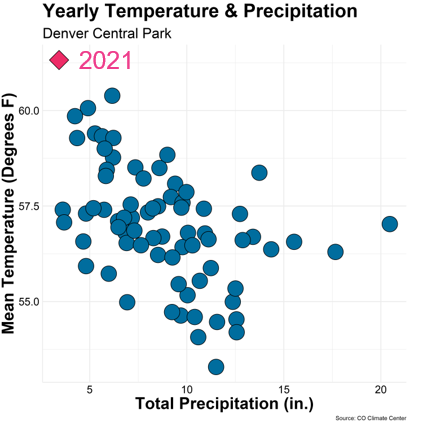
2) Unprecedented Warm and Dry Conditions
The second half of 2021 was not only extremely dry in the Denver / Boulder region, but it was also the warmest June – December on record, by a large margin. When temperatures are warm, the atmosphere will pull moisture from surface water features, soils and vegetation. In addition to a lack of precipitation, this evaporative drying led to a further curing of the grasses and fuels in the region.
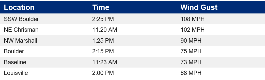
3) Mountain Wave Wind Event
High wind events, especially in the winter, are not uncommon in the foothills and adjacent plains of Colorado. Downsloping winds coming off of the Rockies gain speed and warm up as they impact the populated areas of the Plains. Winds of up to 70 mph are not uncommon, however the observed gusts of 90 to 110 mph on December 30th were on the high end of normal for these types of events. The combination of high winds and very dry fuels allowed the Marshall Fire to rapidly progress.

4) The Built Environment
The Marshall Fire was the most destructive fire in Colorado history, driven by strong downsloping winds and unseasonably dry fuels. While the final fire footprint is estimated to be 6,000 acres, it forced the evacuation of over 35,000 residents and eventually destroyed an estimated 991 structures, including residences and large commercial buildings. Losses are expected to exceed the 193,000 acre East Troublesome Fire of 2020, which caused $560M in insured loss.
What began as a grass fire quickly became an urban conflagration, as the fire moved into a densely populated suburban area and jumped from structure to structure very quickly under high wind conditions. A large majority of structures that burned were in the Wildland Urban Interface or Intermix (yellow and orange at left), or WUI. The WUI is becoming increasingly vulnerable to high impact wildfires as climate change causes wildfire season to lengthen, and worsens the conditions that can lead to intensely burning and quick moving wildfires.
Climate Change Context
Most large and damaging wildfires in United States in the past decade have had several things in common; dry fuels, strong winds, and structures within the WUI. In Colorado, strong wind events are very common in the winter, however typically there is a layer of snow on the ground, or moisture from previous snow events has moistened the vegetation enough to prevent rapid spread of fire. In 2021, the second half of the year had been dry and warm, leaving grasses and vegetation primed for rapid spread of fire. As climate change continues to alter temperature and precipitation patterns across the US, the confluence of high winds and dry fuels may become more common, allowing for fire season to stretch weeks to months longer.

Marshall Fire Site Visit
Guy Carpenter wildfire scientists visited the burn site with experts from IBHS, Boulder Wildfire Partners, and the Colorado State Forest Service. It was reinforced that building characteristics and mitigation measures play a role in overall suseptibility to wildfire. One neighborhood, Sagamore, was a total loss, with houses spaced only 9-10 feet apart, making home to home ignition much more likely. Additionally, double or triple paned windows performed much better in high heat conditions, while fence lines proved to be a major point of vulnerability as a continuous source of fuel to the structure at risk.
Vulnerability
Building characteristics and mitigation measures play a role in overall susceptibility to wildfire. One neighborhood, Sagamore, was a total loss, with houses spaced 9-10 feet apart. The Guy Carpenter Urban Conflagration Index attempts to quantify the risk of high density housing co-located with high hazard fuels and terrain, as seen below.

Structure Wildfire Susceptibility
- Structure Spacing
- Multi-Pane Windows
- Building Materials
- Ember Resistance
9 Foot Home Spacing
.png)
Additionally, double or triple paned windows performed much better in high heat conditions, while fence lines proved to be a major point of vulnerability as a continuous source of fuel to the structure at risk.
Triple Pane
.png.thumb.319.319.1643302307000.png)
Wood Fences
.png)
Foliage Freeze
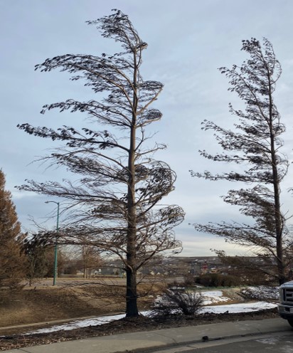
In the case of fires, the primary form of evidence are "indicators"—physical objects carrying traces of a wildfire’s spread. A telltale indicator of wind direction is “foliage freeze”. As a fire passes, leaves, needles and stems of trees become pliant in the presence of extreme heat and bend in the direction of the wind. They remain pointed in this direction as they cool and stiffen.
The CAT Resource Center
Post Event Summary: Marshall Fire
Driven by 60 to 100 mph wind gusts and aided by extremely dry grasses and fuels, the Marshall Fire rapidly spread into the Boulder area communities of Superior and Louisville, destroying over 900 homes in a matter of hours.