

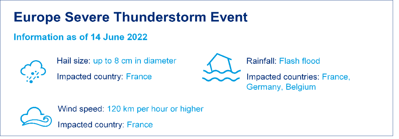
Severe thunderstorm outbreaks impacted France, Germany and Belgium around Pentecost weekend (3-6 June). There were many reports of large hailstones in France, causing significant damage to property and motor vehicles. There also was damage from wind and flooding in France, Germany and Belgium.
This severe thunderstorm post-event report comprises the following sections:
- Insured Loss Estimates
- Regional Impacts
- Key Dates in the Timeline
- Physical Discussion of Meteorological Conditions
- Comparison with Hail Storm Ela (2014)
- Climate Change
Insured Loss Estimates
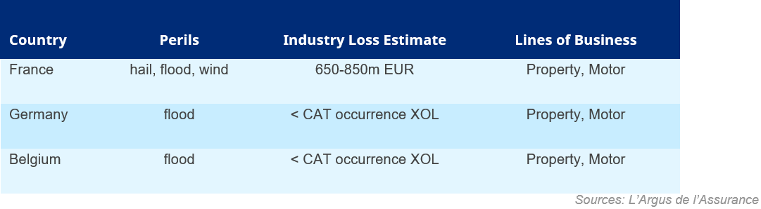
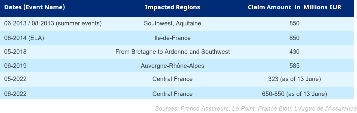
As of 13 June, L’Argus de L’Assurance had reported an industry loss estimate of EUR 650-850 million. In terms of losses in France, this event may be the largest since Hailstorm Ela in 2014. The following table summarizes current view of the losses based on Guy Carpenter’s sources.
Key Dates in the Timeline of June 2022 Severe Thunderstorms
Regional Impacts
France
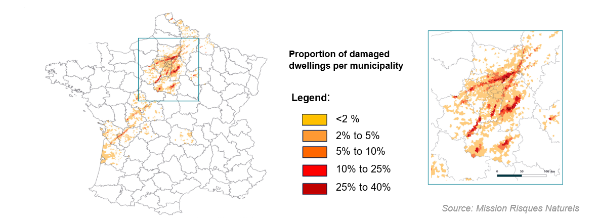
From the middle of May to the beginning of June, the meteorological situation was conducive to large-scale thunderstorm events. After a first hail outbreak during 18-23 May, with huge damage in the city of Chateauroux, a broader event developed by the Pentecost weekend and caused damage stretching from southwest to northeast France, associated with a disturbance named Maya by the University of Berlin.
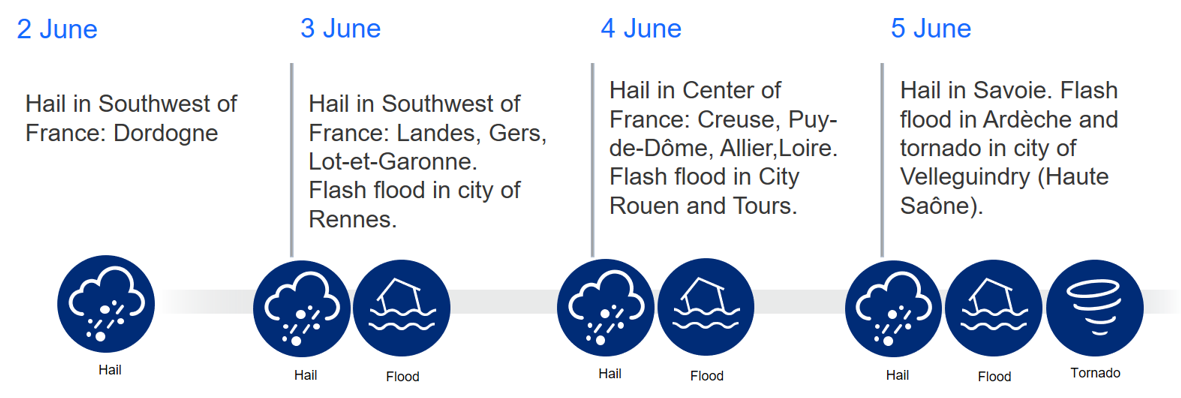
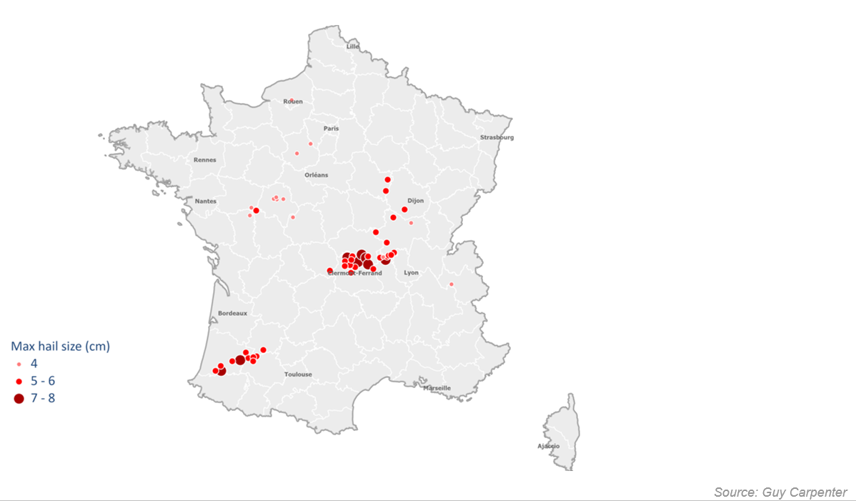
The disturbance expanded and caused flash flooding in Dordogne on Thursday, 2 June. Then, a supercellular thunderstorm emerged in the southwest over eastern Landes, northern Gers, and southern Lot-et-Garonne, raining large hailstones that exceeded 5 cm in diameter on Friday, 3 June.
In addition, heavy flash floods occurred in the northwest of the country, especially in the city of Rennes. On 4 June, multiple supercell thunderstorms simultaneously dumped hailstones onto Loire, Puy-de-Dôme, Allier and Creuse. The city of Vichy in Allier was especially affected by hailstones of 7 to 8 cm, sustaining great damage. Flash floods inundated the city of Rouen in Seine-Maritime, where a woman died. On Sunday, 5 June, thunderstorms shifted eastward, bringing heavy rainfall and hail damage to some localities in the Alps and the Rhône Valley.
It was reported that Covéa estimated this event to generate 230,000-250,000 motor vehicle and property claims with a market loss between EUR 650 million and 850 million (40% motor, 60% property). They accumulated to an estimated market loss between EUR 800 million and 900 million. While hail was the dominant driver of these losses, flood and wind damage also contributed.
Germany
On 5 June, severe thunderstorms swept across the south and southwest of Germany. In the Lindau district of Allgäu, roads were covered in a thick layer of hail. There also were reports of fallen trees, but no reports of injuries or major damage.
Enzkreis in Baden-Württemberg received up to 60 mm of precipitation in the form of hail and heavy rain, with several streets flooded within a few minutes. The areas around Pforzheim, Mühlacker, Maulbronn and Sternenfels were most affected. There also was heavy rain in the Bavarian Forest and in Upper Bavaria. Several rivers, such as the Große Vils, burst their banks, and roads were flooded in Rosenheim, Traunstein, and the district of Erding.
Especially in southern Germany, the storms caused much damage with falling roof tiles, lightning strikes and flooded cellars. Trees fell on several cars in Bavaria, but no one was injured. In Aschbach of Rhineland-Palatinate, a storm damaged the roofs of about 20 houses. In Hesse, storms flooded some cellars and flats, most notably in Darmstadt and the Darmstadt-Dieburg district.
Belgium
On 5 June, Belgium was impacted by heavy rain. Throughout the morning, parts of the provinces of West Flanders and East Flanders experienced a squall line and rainfall of up to 95 mm/day or 40 mm/h was recorded.
This severity corresponds to a return period of 100 years. In the rest of the country, smaller return period (20 years and lower) amounts were recorded. In Lievegem, some houses–along with sheds, garages and cellars–were flooded up to 2-4 cm. In Hansbeke, traffic on the Julius Nieuwlandweg highway was diverted because of flooded tunnels (60 cm).
During the afternoon, a low-pressure thermal system affected Limburg and Flemish-Brabant, and precipitation of up to 60 mm was observed. In Landen, a railway station had to contend with excess water. Moreover, several municipalities (Linter, Dessel and Gingelom) were hit by small mudflows. In some areas, overland flow from bare fields funneled into nearby streets, causing cars to be carried along by the muddy water.
Physical Discussion of Meteorological Conditions
The formation of thunderstorms, along with resulting tornadoes, hail, wind and rain storms, is dependent on a number of factors. In simple terms, thunderstorms occur when warm, moist air rises into cold air above and condenses repeatedly, forming a convective cell. The updraft areas in convective cells then further pull up the warm, unstable air. Vertical wind shear means that rain and the associated cold air do not fall through the updraft, allowing the convection to continue. Hailstones can be pulled upward repeatedly, growing larger and larger over time.
Rising air is attributable to three main mechanisms:
- Landscape features, such as mountains.
- Unstable air masses, for example due to strong heating of the ground in the summer.
- Boundaries of weather fronts, usually along cold fronts where the denser cold air pushes under and lifts up the warmer air.
Conditions during the end of May and beginning of June included heatwaves over southern continental Europe and several low-pressure systems over the Atlantic Ocean, with thunderstorms developing along cold fronts. These accumulated by 3 June, when a low-pressure system approached western France, ambling eastward to affect the Benelux countries and Germany over the next two days. High surface air temperatures ahead of the low-pressure system and cold air in the upper atmosphere fueled the formation of large hail stones along the low-pressure system’s weather fronts.
Such hail storms occur frequently in France, depending on more or less favourable formation conditions. These situations occur most often at the end of spring and beginning of summer, on a southwest to northeast axis following the track of low-pressure systems that bring in cooler Atlantic air. This cooler air can become unstable in the early summer heat, permitting the formation of thunderstorms, particularly with the passage of weather fronts associated with these low-pressure systems.
Comparison with Hail Storm Ela (2014)
This recent June hail storm is probably one of the most important events since Ela of 6-10 June, 2014.
Overall, the weather patterns have been very similar to those of Ela. In both cases, a low-pressure system approached the western coast of France, inducing an air mass disturbance along a cold front for several days. However, Ela’s low-pressure system was stronger, inducing more powerful air mass disturbances and consequently greater damage.
The France Assureurs (FA) estimated the overall cost of Ela at EUR 850 million for 363,000 claims in 2014. This was the most expensive hail event in history since FA began providing loss statistics. As a result, the year 2014 alone accounted for nearly a quarter of all hail losses between 1990 and 2015.
To put the current event in perspective, a table of recent severe thunderstorm events is presented below:
Climate change
Although it is difficult to link individual events directly to global climate change, model simulations indicate that the changing climate will increase the likelihood of conditions such as those seen this spring, which enabled severe thunderstorms to develop.
Future climate projections are typically conducted using global and regional climate models, run at relatively coarse resolution for long periods. This means that small-scale thunderstorm or hail events cannot be represented directly in these models, and projections rely on the proxy relationships between large-scale atmospheric patterns and small-scale weather events.
In addition, various atmospheric and oceanographic mechanisms are affected by climate change in a multiplicity of ways that do not all push in the same direction simultaneously. Consequently, the future impact of climate change on thunderstorms and hail events is difficult to forecast with a reasonable degree of accuracy.
Nevertheless, there is general agreement that climate change will increase low level moisture and instability, thereby fostering environments conducive to severe thunderstorms (Raupach et al., 2021[1]; Allen 2018[2]; Púčik et al., 2017[3]; Rädler et al., 2019[4]). Regional climate model simulations project an increase in the frequency of lightning, large hail and straight-line wind throughout most of Europe by 2100 (Rädler et al., 2019).
[1] Raupach, T.H., Martius, O., Allen, J.T. et al., 2021. The effects of climate change on hailstorms. Nat Rev Earth Environ 2, 213–226 (2021).
[2] Allen, J. (2018, July 30). Climate Change and Severe Thunderstorms. Oxford Research Encyclopedia of Climate Science. Retrieved 20 Apr. 2021, from https://oxfordre.com/climatescience/view/10.1093/acrefore/9780190228620.001.0001/acrefore-9780190228620-e-62.
[3] Púčik, T., Groenemeijer, P., Rädler, A.T., Tijssen, L., Nikulin, G., Prein, A.F., van Meijgaard, E., Fealy, R., Jacob, D. and Teichmann, C., 2017. Future changes in European severe convection environments in a regional climate model ensemble. Journal of Climate, 30(17), pp. 6771-6794.
[4] Rädler, A.T., Groenemeijer, P.H., Faust, E. et al., 2019. Frequency of severe thunderstorms across Europe expected to increase in the 21st century due to rising instability. npj Clim Atmos Sci 2, 30 (2019).