
Key Headlines
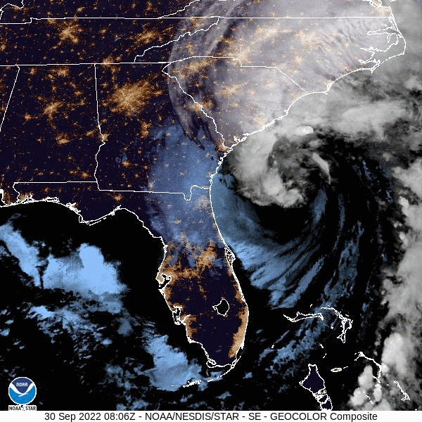
- Ian cleared the Florida Atlantic Coast yesterday, and regained hurricane strength at 5PM EDT due to warm waters of the Gulf Stream and interaction with another frontal system approaching from the Mainland.
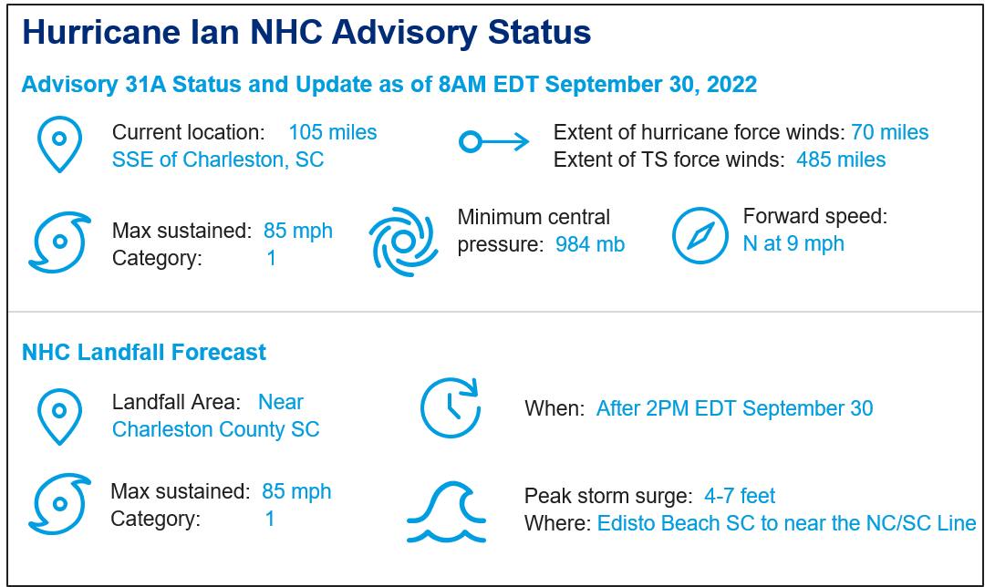
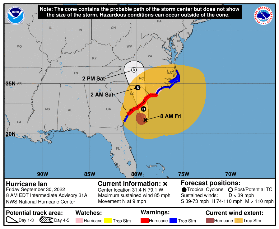
- Ian now carries maximum sustained winds of 85 mph, a category-1 hurricane, with a forward speed to the north at 9 mph. The National Hurricane Center (NHC) best forecast takes the core of Ian into South Carolina today shortly after 2PM EDT, without further gain in intensity. Conditions have already moved ashore in the Carolinas.
- Ian is an impressively large storm, with tropical storm force winds extending outward from the center to 485 miles. Impacts will extend well away from the center of the storm. Tropical Storm, Hurricane and Storm Surge Warnings remain active per the NHC, with specifics available at www.nhc.noaa.gov.
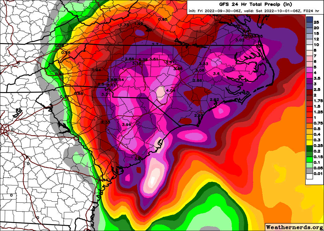
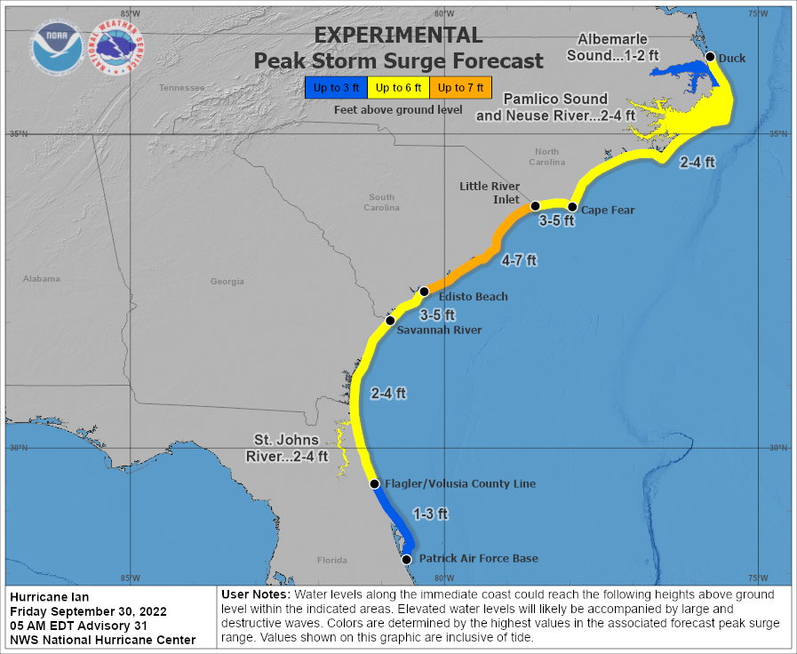
- The strongest hurricane conditions will be experienced in and around the landfall area of Charleston County, SC, with tropical storm conditions having already moved ashore and affecting nearby states of Georgia, the Carolinas and parts of Virginia. A very large storm surge 4-7 feet above normal tidal levels, combined with high tides, will bring seawater inundation and water velocity damage to coastal areas and connected waterways extending well inland from the coast, with wave battering for immediate coastal areas. Additional heavy rainfall amounts of 4-8 inches with local amounts to 12 inches will bring inland riverine and flash flooding to the Southeast and Mid-Atlantic States.
- Following landfall, Ian should become an extratropical low (frontal system) over North Carolina before dissipating over the weekend. Heavy rainfall and gusty winds along with a few tornadoes will remain as ongoing threats.
What is the Final Forecast for Ian and Why?
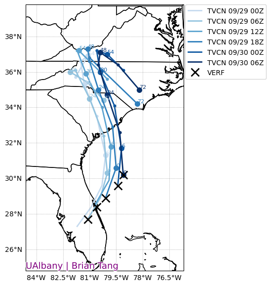
As of 8 am EDT, Hurricane Ian was located roughly 105 miles SSE of Charleston, South Carolina, and moving slowly to the north-northeast. The storm is highly asymmetrical, meaning that the majority of deep convection (thunderstorm activity) is located on one side of the hurricane eye - in this case to the west. The extent of tropical storm force winds is also extremely large. Although there is a significant amount of wind shear present in the environment, Ian is tapping into the warm waters of the Gulf Stream to maintain hurricane strength. The NHC official track takes Ian inland just north of Charleston this afternoon, however there is still a bit of uncertainty regarding the exact track. In fact, Ian has continued to track further east than model guidance over the past 24 hours, increasing the threat of inland flood and surge risk in North Carolina and even Virginia as compared to prior forecast cycles. After landfall, Ian should weaken rapidly and dissipate somewhere near the border of North Carolina and Virginia by Saturday night.
What Storm Surge Effects Should We Expect in the Carolinas?
Ian’s approach to the South Carolina coast brings hurricane force winds near the core and an impressively large tropical storm force wind field that should generate significant surge impacts along the Southeast US coast. Current surge model forecasts from the NHC and Coastal Emergency Risks Assessment (CERA - https://coastalrisk.live/) anticipate maximum surge levels of six to teen feet of surge above mean sea level (MSL). These maximum surge elevations are expected just to the east of the forecast landfall location. Most recent forecasts indicate a landfall to the east of Charleston, SC meaning the city would avoid the most intense surge impacts although current models indicate Charleston will experience surge levels of five to seven feet with some impacts from surge to be expected. Tidal amplitudes in the region of landfall are on the scale of four feet meaning that depending on the precise timing of landfall tidal influence may significantly impact local flooding levels. Ian’s large wind field means that surge impacts will be felt over numerous tidal cycles.
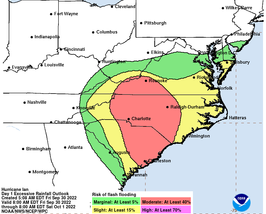
How Severe Should Inland Flood Effects Be?
As Ian moves closer to landfall in South Carolina, NOAA projects moderate flash flooding potential for the eastern part of the state. The heavy rainfall coincides with rising tides, increasing the potential for flash flooding, especially for those stormwater management systems impeded by storm surge. In the Charleston area, 1-2 inches of rain has already fallen, with an additional 2-6 inches forecasted in the in the next 24-48 hours, per the National Weather Service.
How Are Impacts Unfolding In Florida?
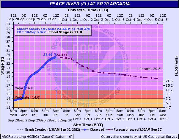
Although Ian has cleared Florida, many areas around the state are still experiencing flooding. Central Florida saw the worst of Ian’s rainfall, experiencing 20 inches over the course of 72 hours. From Tampa through Orlando and up the coast to Jacksonville, 33 gauges are still in flood stage, including 18 at major flood stage. Currently, record flood levels can be found in central Florida and along the Peace River near Port Charlotte, with the latter seeing flooding 3 feet above the previous record.
Concerning storm surge in northeast Florida, Ian’s large wind field brought moderate flooding due to the broad continental shelf offshore, with elevated water levels still occurring this morning. Water levels in downtown Jacksonville reached 3.4 feet above MSL which NOAA categorizes as Moderate flooding impacts. At the NOAA station at Fernandina Beach, FL, near the Florida-Georgia border, water levels reached a maximum (as of this writing) of 6.6 feet above MSL which would be the sixth highest recording ever at the station. In Florida the surge generated offshore and driven up coastally connected rivers has compounded flood effects from the historic rainfall amounts the region experienced from Ian’s passage.
Damage assessment and rescue operations remain in effect for southwest Florida meaning assessments of maximum water levels from Ian will be delayed. Numerous rapid deployment gauges were placed in the region of expected maximum surge meaning that in the coming days a better view of Ian’s surge extent will become apparent. A rapid deployment gauge near Fort Myers that has reported data indicates a surge of approximately 7.2 feet above NAVD88 datum. This same location recorded a surge elevation of 3.4 feet for 2017’s Hurricane Irma.
Statements from the National Hurricane Center and official emergency management and forecast agencies supersede this update and should be closely followed concerning matters of personal safety.