
- Cyclone Gabrielle triggered the 3rd national state of emergency in New Zealand’s history.
The other 2 instances were triggered by the Christchurch Earthquake in 2011 and COVID-19 in 2020. - This event is complex, with multiple sub-perils: wind, flood, storm surge and landslide, with flood causing the most damage.
- Gabrielle cut a wide swath from the Muriwai and Piha beaches on the west coast to the Hawke’s Bay region on the east coast of the North Island.
The Cyclone Gabrielle post-event report comprises the following sections:
- Meteorological Background
- Damage Impacts
- Portfolio Properties in Flood Event
- Perspective from Historical Cyclones
- Market Impact
Meteorological Background
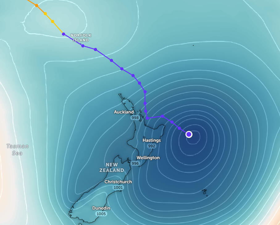
A tropical low developed near the Solomon Islands, then moved toward Queensland, Australia, as a tropical cyclone. It was named Gabrielle by the Australian Bureau of Meteorology (BOM). The storm then veered southeast, travelled between New Caledonia and Australia in the Coral Sea, and intensified to a Category 3 severe tropical cyclone. As it travelled further, it met a northwesterly vertical wind shear and weakened. It transitioned into a deep subtropical low as it passed by Norfolk Island. It continued north of New Zealand, dipped closer as it went by the Coromandel Peninsula, skirted north of Hicks Bay and went out to sea. Figure 1 represents the strongest of 6 hourly snapshots of Gabrielle’s surface wind, precipitation and sea-level pressure as the storm approached New Zealand.
Figure 1: Surface winds (arrows), precipitation (shadings), and mean sea-level pressure (contours) 01:00 NZT, 14 February, 2023.
Source: ECMWF Reanalysis 5; Graphic: Guy Carpenter
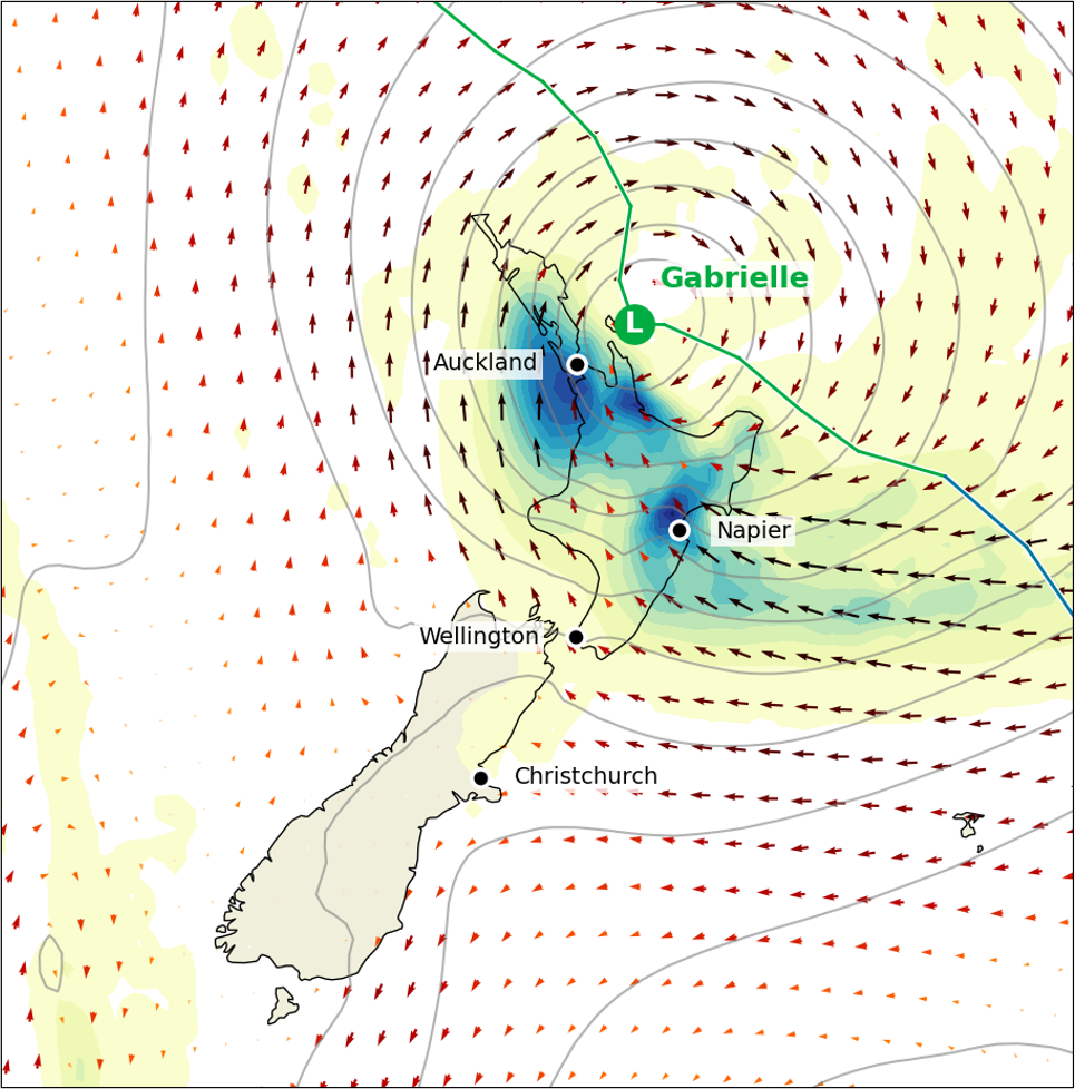
Cyclone Gabrielle delivered severe southwest wind gusts of up to 90-110 km/hour over Auckland city. In addition, record storm surges and large waves inundated eastern coasts of the North Island. The system resulted in daily rainfall totals exceeding 200 mm across large parts of the North Island and isolated totals exceeding 400 mm. Heavy rainfall led to dangerous river conditions, with some bursting their banks. Figures 2 and 3 indicate the wind and rainfall footprints of Cyclone Gabrielle.
Figure 2 and 3: Map of Cyclone Gabrielle’s wind field (left) and rainfall footprint (right).
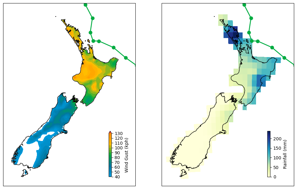
Sources: ECMWF Reanalysis 5, NOAA Climate Prediction Center; Graphic: Guy Carpenter.
Damage Impacts
Extensive floods and mudslides damaged properties along the beaches of Muriwai to Piha in the northwest Auckland region and the towns of Gisborne, Wairoa, Napier and Hastings in the southeast. Not only were properties damaged, but the impact also extended to the infrastructure of bridges, roads and highways, crops and livestock. The silt and debris on properties and roads have made recovery work very difficult, and helicopters were used to airlift people to safety and drop off supplies to isolated communities. The power supply was cut for many, and as of this writing, some are still without electric power. Figure 4 indicates the towns with severe damage.
Figure 4: Map of Hawke’s Bay (left) and a zoomed-in view of the affected suburbs in Hawke’s Bay (right).
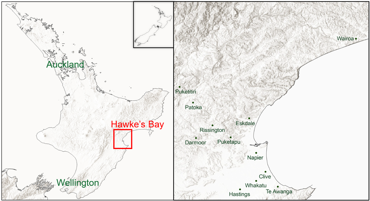
Sources: Guy Carpenter / media articles
Recent ocean-atmosphere conditions increased the destructive potential of low-pressure systems. La Niña, a climate state that pushes warmer ocean water toward the western Pacific, occurred for the 3rd year in a row in the summer of 2022-23. Cyclonic circulation became more common in the Coral Sea, driving more moist warm air toward New Zealand. Furthermore, the country has experienced 3 back-to-back record-warm winters since 2020, as well as 2 record-setting warm years (2021 and 2022). Since warmer air can carry more moisture and warmer sea water evaporates more water into the air, the recent state of the climate likely intensified low-pressure systems and their impacts on New Zealand.
Portfolio Properties in Flood Extent
Guy Carpenter has undertaken portfolio mapping for several towns across Hawke’s Bay, based on flood extents provided by Geospatial Insight (GSI). These flood extents attempt to capture damages from only pluvial flooding and not from wind, rainwater and/or water ingress. Figure 5 highlights the properties in the flood extents for the market portfolio in Napier.
Figure 5: Market Portfolio in flood extents.
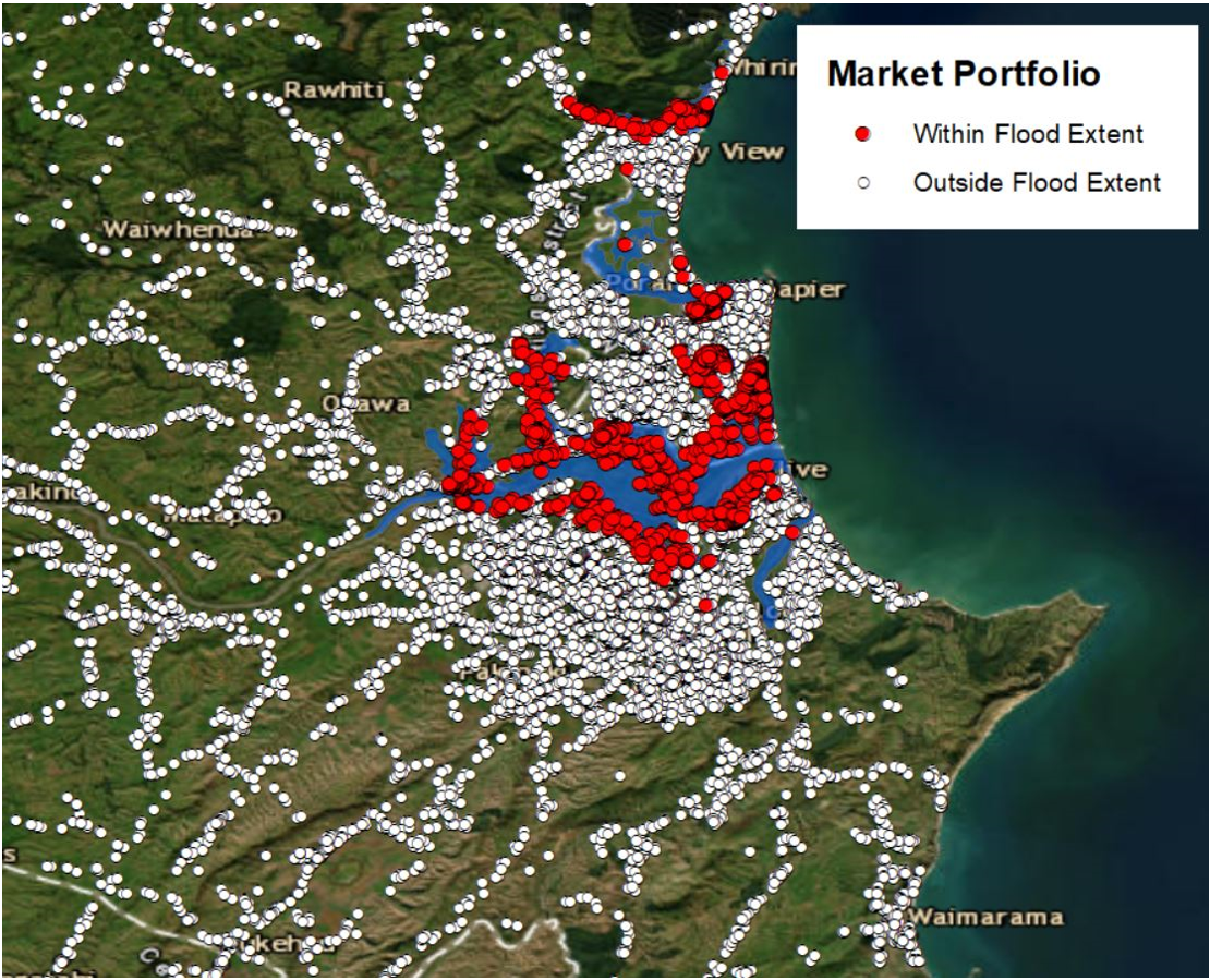
Sources: Land Information New Zealand (LINZ)/ GSI
Perspective from Historical Cyclones
Table 1: Highlights of historical cyclones in New Zealand.
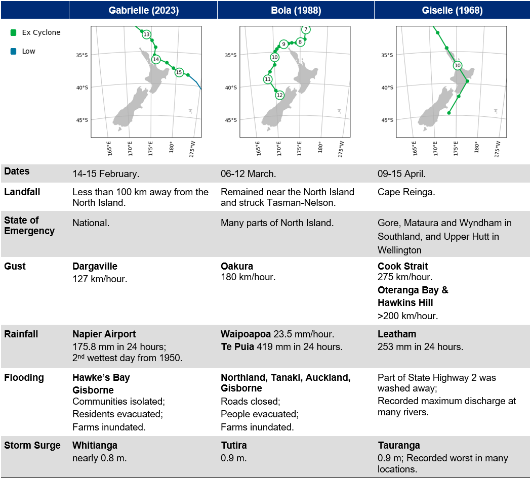
Sources: NZ Herald, NIWA, MetService, BOM, National Emergency Management Agency.
Cyclones Giselle and Bola, occurring 55 and 35 years ago, respectively, are notable cyclone events in New Zealand. In particular, Giselle is remembered for the shipwreck of the ferry, TEV Wahine. Bola was an exceptionally wet storm. Similar to Gabrielle, it also made an impact in rural areas and caused agricultural damage.
Market Impact
Cyclone Gabrielle made its passage over New Zealand only 2 weeks after the Auckland flooding event. The antecedent condition magnified Gabrielle’s impact. Reviewing the 55 years of cyclone events in the ICNZ database (1968-present), there has not been a cyclone occurrence so closely following a large flooding event. This short gap is rare.
The 2 events will add to inflationary pressures in New Zealand’s domestic economy, especially relating to rent, construction and food (since the country will need to increase imports to replace crop losses). In some cases, properties cannot be rebuilt on the original plots of land, and the occupants will relocate to more suitable grounds. There is an effort to build back better and make New Zealand more resilient to natural catastrophes.
When it comes to damaged automobiles, New Zealand is heavily reliant on the import of repair parts and new vehicles, where there is currently a global shortage. There will be delays in getting replacements.
One special coverage benefit from New Zealand’s Earthquake Commission (EQC) EQCover is that it pays for qualified residential land damage caused by storms and floods. Therefore, Gabrielle’s claims are insured by both the private market and EQC.
The frequency and complexity of these weather events, which bring the sub-perils of wind, storm surge, landslide, pluvial and fluvial flood, make it very challenging to model and expensive to obtain lower-layer and aggregate protection. Other reinsurance solutions may need to be considered—such as structured and parametric arrangements—to complement traditional coverage if retentions increase because of price and availability pressures.
Sources: New Zealand Herald, Sydney Morning Herald, Stuff, Reuters, Newshub, Artemis, The Conversation, ourAuckland, Informetrics, Earthquake Commission (EQC), GeoSpatial Insight (GSI), Land Information New Zealand (LINZ), Meteorological Service of New Zealand (MetService), Australian Bureau of Meteorology (BOM), Insurance Council of New Zealand (ICNZ), European Center for Medium-Range Weather Forecasts (ECMWF), National Institute of Water and Atmospheric Research (NIWA), NOAA–Climate Prediction Center, Radio New Zealand, Intergovernmental Panel on Climate Change (IPCC), National Emergency Management Agency.