

- A strong Mw 7.8 earthquake struck southern Turkey in the early morning of February 6, with an epicenter just over 30 km from the city of Gaziantep.
- This is the largest magnitude earthquake recorded in Turkey since the 1939 Mw 7.8 Erzincan earthquake.
- Around 9 hours later, a Mw 7.5 earthquake shook the same region, with an epicenter 95 km to the northeast of the first earthquake.
- In addition to the 2 main earthquakes, there have been numerous ongoing aftershocks (more than 1,000 reported at the time of writing) up to Mw 6.7.
- At the time of writing, over 15,000 fatalities have been reported.
The Southern Turkey Earthquakes post-event report comprises the following sections:
- Physical Discussion of the Earthquakes
- Seismotectonic Context
- Damage Impacts
- Loss Estimation
- Comparison with Historical Events
Physical Discussion of the Earthquakes
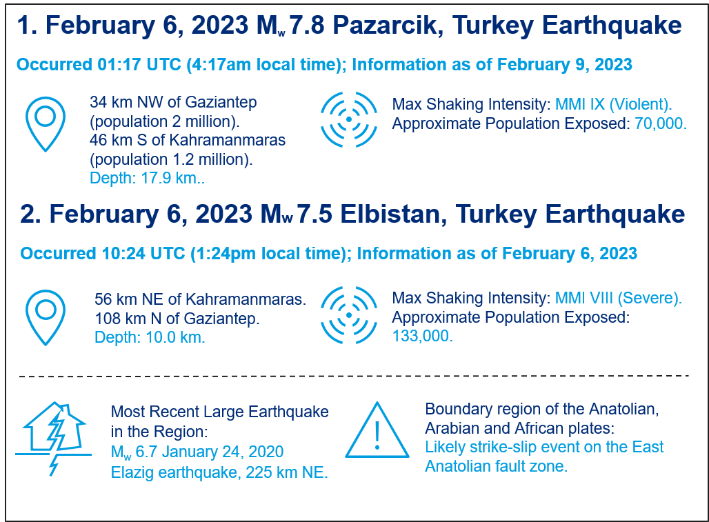
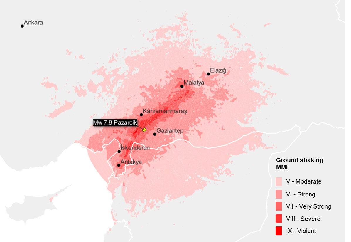
The first shock in the sequence struck at 4:17 a.m. local time on February 6, 2023, with Mw 7.8 and at a shallow depth of 17.9 km. The epicenter was located 34 km to the northwest of Gaziantep, a major city with a population of more than 2 million, and 46 km to the south of Kahramanmaras, another large city with a population of 1.2 million. Given the magnitude of the earthquake, the fault rupture is estimated to be 190 km long and 25 km wide. The rupture propagated to the northeast of the epicenter, which is where the strongest ground-shaking was observed, but shaking was also felt in Cyprus, Lebanon, Israel and Syria, with substantial damage in northern Syria. On the Modified Mercalli Intensity (MMI) scale, this earthquake reached MMI IX (Violent shaking), with around 70,000 people exposed to this intensity. The U.S. Geological Survey (USGS) PAGER system estimates that almost 40 million people were exposed to at least MMI V, which is the level at which structural damage starts to be observed. The USGS ground-shaking footprint for this earthquake is shown in Figure 1. It should be noted that USGS footprints are simulated based on observations from seismic recording stations and damage reports, so some uncertainty remains.
Figure 1: USGS simulated ground shaking intensity of the Mw 7.8 Pazarcik earthquake (4:17 a.m. local time).
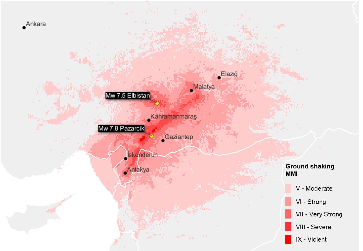
Numerous aftershocks shook the region for the rest of the morning, including one with Mw 6.7 just 11 minutes after the first earthquake. Then at 1.24 p.m. local time, a second large Mw 7.5 earthquake occurred, with an epicenter 95 km to the northeast of the first earthquake and at shallow depth of 10 km. Although much further from Gaziantep and Kahramanmaras, it occurred just 20 km from the town of Elbistan (approximate population 80,000), and much of the shaking footprint of this subsequent earthquake overlaps with the initial one, potentially causing further damage to already weakened structures. The maximum intensity of the second earthquake was MMI VIII (Severe shaking), with the USGS PAGER system estimating that around 133,000 people were exposed to this intensity. It is estimated that more than 20 million people were exposed to at least MMI V. The USGS ground-shaking footprint is shown in Figure 2. A combined footprint showing the maximum simulated ground-shaking intensity at each location across both major earthquakes is shown in Figure 3.
Figure 2: USGS simulated ground shaking intensity of the Mw 7.5 Elbistan earthquake (1:24 p.m. local time).
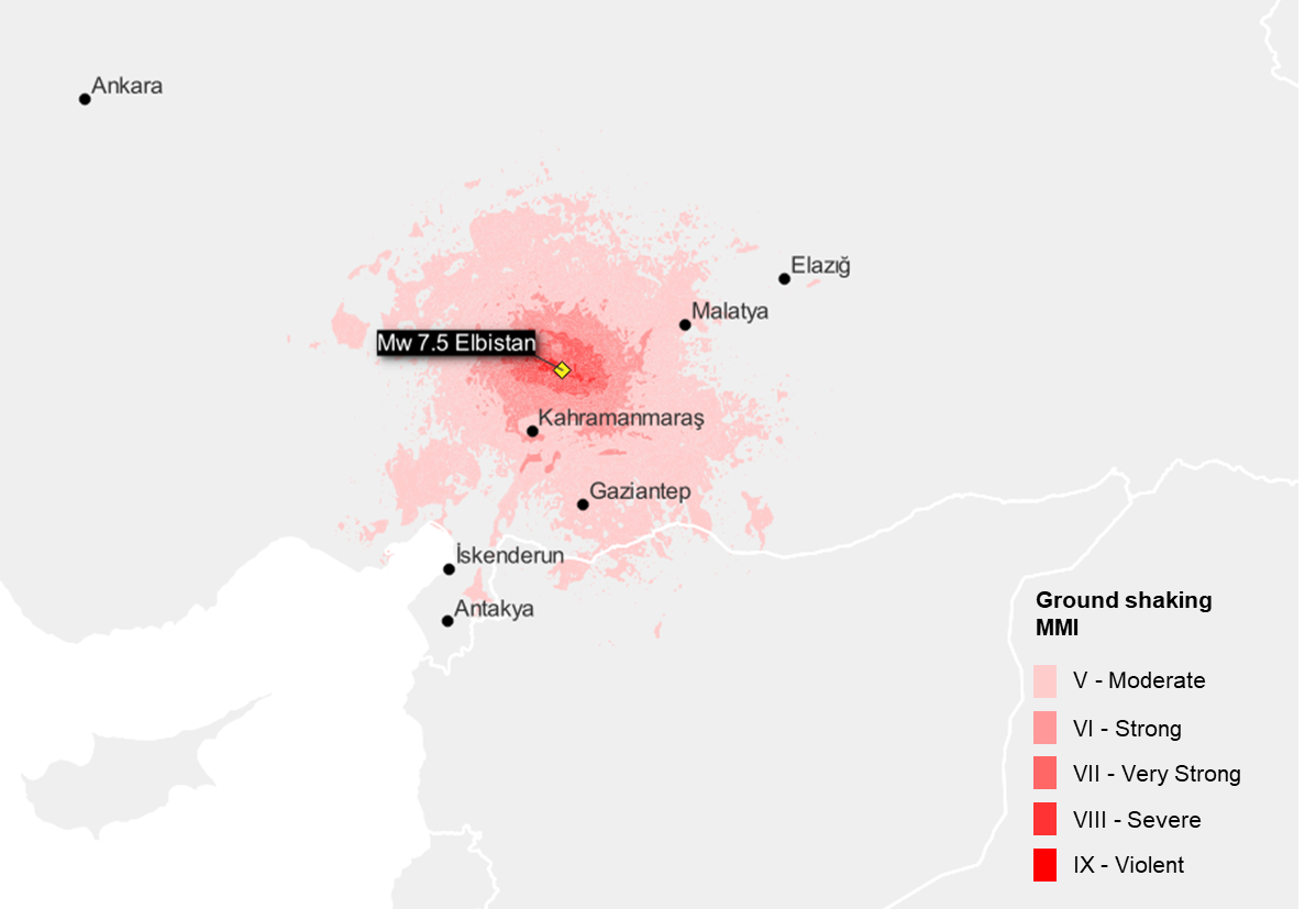
Figure 3: Maximum shaking intensity across both major earthquakes from USGS simulated footprints.
Seismotectonic Context
Turkey is characterized by 2 major fault zones—the East Anatolian fault zone (EAFZ) in the south and east of the country, and the North Anatolian fault zone (NAFZ), which runs along the northern edge of the country. The 2 major earthquakes in this sequence resulted from strike-slip faulting at shallow depths, most likely in the left-lateral direction, which is consistent with the motion of the EAFZ. The EAFZ is at the junction of the Anatolian, Arabian and African tectonic plates. While Turkey is gradually being pushed northward by the Arabian plate, the central part of the country is squeezed in between the EAFZ and NAFZ and pushed westward into the Aegean Sea. The fault zones and plate boundaries around Turkey are shown in Figure 4.
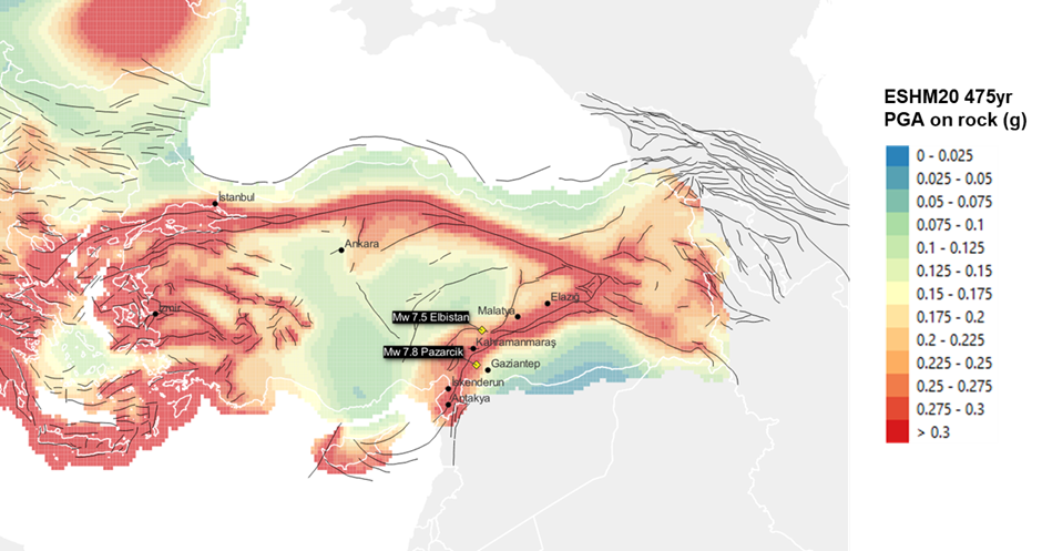
The recently published European Seismic Hazard Map (ESHM20, shown in Figure 5) estimates that the 475-year return period (10% probability of exceedance in 50 years) ground-shaking around the EAFZ as high as 0.5 g, which makes it one of the most seismically active parts of Europe. Prior to 1900, there have been many historical earthquakes around the EAFZ, notably the 2 destructive Mw 7+ events that hit Aleppo, Syria, in 1138 and 1822. More recently, the southern half of the EAFZ has been relatively quiet, creating a seismic gap where there had been a longer than expected time between earthquakes. Since 1970, there have been only 3 Mw ≥ 6 events within a 250 km radius of the Pazarcik earthquake. While recent events in 2010 and 2020 close to Elazig have relieved some of the pressure in the central part of the EAFZ, the southernmost part, which includes the region affected by this current sequence, had not seen a significant large earthquake for more than 500 years. The initial earthquake occurred on the Pazarcik segment of the EAFZ, where the estimated return period of Mw 7.0-7.4 events is 237-772 years.[1]
Figure 4: Major fault zones and movement of plate boundaries in Turkey.
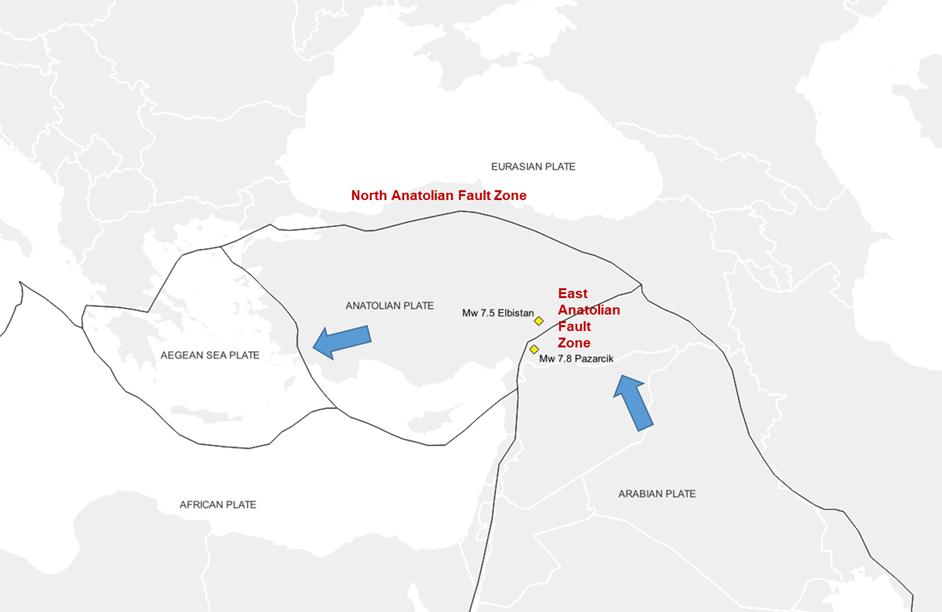
Figure 5: European Seismic Hazard Map (ESHM20) 475-year return period peak ground acceleration (PGA) on rock conditions (known faults contributing to the hazard map are shown as black lines).
Damage Impacts
As the death toll surpasses 15,000 from the series of earthquakes, news reports indicate that there has been extensive damage to buildings and infrastructure across the region. Government officials in Turkey reported severe damages in 10 cities: Gaziantep, Kahramanmaras, Hatay, Osmaniye, Adiyaman, Malatya, Diyarbakir, Sanliurfa, Adana and Kilis. Videos from news outlets and social media show mid- and high-rise buildings swayed and many partially or fully collapsed to the ground, and some villages have been destroyed.
The ancient Gaziantep Castle was turned into ruins, and several mosques sustained serious damage. A fire from burning containers was seen at the earthquake-stricken port of Iskenderun. Iskenderun is a vital port for transport of heavy industries, so cargoes have to seek alternative routes. Crude-oil loading at Ceyhan Port on the Mediterranean coast has been suspended, as is the case for several other ports as well. The only airport in Hatay had its runway damaged, and is closed to traffic. The Ministry of Transport and Infrastructure surveyed many deformed railways lines, and train traffic in southeastern Turkey is suspended. Suspension of ports and rails not only impacts supplies for Turkey, but also goods to Europe. Many highways and roads in cities and villages buckled, causing difficulties in delivering rescue supplies.
Guy Carpenter will carry out a review of the damages in order to quantify and explain the scale of the destruction that has been observed. Aside from the magnitude and depth of the earthquake, both of which could be expected to lead to significant damage, we will also consider the sufficiency of building codes in the region, along with the quality of regulation and enforcement.
Loss Estimation
It is too early to produce reliable industry loss estimates. The information on the observed shaking intensities is still being updated by organizations such as AFAD and USGS. However, Guy Carpenter is working with clients to provide early loss estimates for their portfolios. We are using scenario events taken from the catastrophe model vendors’ stochastic catalogs that are similar to the earthquakes, both in terms of magnitude and in terms of the event-shaking footprint. As vendors develop custom events for these earthquakes, we will apply them to client portfolios. These estimates will be based on the vulnerability and damage curves of the respective vendors. Please reach out to your account executive or catastrophe analysts if you require further assistance.
Comparison with Historical Events
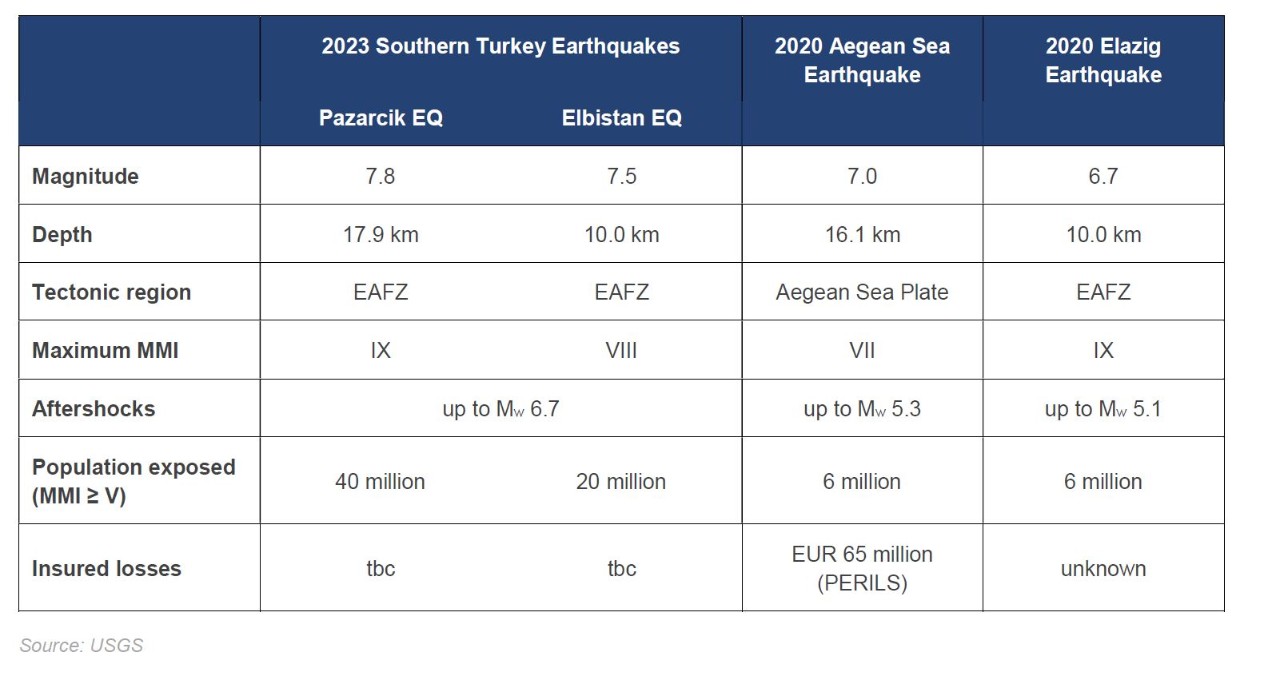
The first earthquake in the sequence is the largest to have hit Turkey since the 1939 Erzincan earthquake, which was also Mw 7.8. The 2 major earthquakes in the current sequence are the 5th and 6th Mw 7+ earthquakes to hit Turkey in the last 25 years, following the 1999 Izmit (Mw 7.6), 1999 Duzce (Mw 7.2), 2011 Van (Mw 7.2) and 2020 Aegean Sea (Mw 7.0) earthquakes. Within this part of EAFZ, the most recent significant earthquakes have been the 2010 Mw 6.1 and 2020 Mw 6.7 Elazig earthquakes.
Table 1: Comparison of major earthquakes in Southern Turkey earthquake sequence with recent significant events in Turkey.
Download the Post Event Report
[1] Guvcerin, S. E., Karabulut, H., Konca, A. O., Dogan, U., & Ergintav, S. (2022). Active seismotectonics of the East Anatolian Fault. Geophysical Journal International, 50-69.
[2] Bird, P. (2003). An updated digital model of plate boundaries. Geochemistry, Geophysics, Geosystems, 4(3), 1027. https://github.com/fraxen/tectonicplates.
Sources: United States Geological Survey (USGS), Temblor, Inc., Disaster and Emergency Management Presidency (AFAD), European Facilities for Earthquake Hazard and Risk, Kandilli Observatory and Earthquake Research Institute, Bogazici University, PERILS, BBC, Reuters, Deutsche Welle (DW), RailTech