An October Update from Global Peril Advisory
Key Takeaways
As of early October, above average activity has defined the 2023 North Atlantic hurricane season. Current storm counts have exceeded pre-season predictions from seasonal outlook providers who called for near-normal activity in the basin for 2023.
While strengthening El Niño conditions were anticipated to limit cyclone activity across the Atlantic, sea-surface temperatures running well above average have played a role in producing an active season.
As of October 4, 17 named storms have formed in the North Atlantic, with 6 of these attaining hurricane strength. Three of these reached major hurricane status.
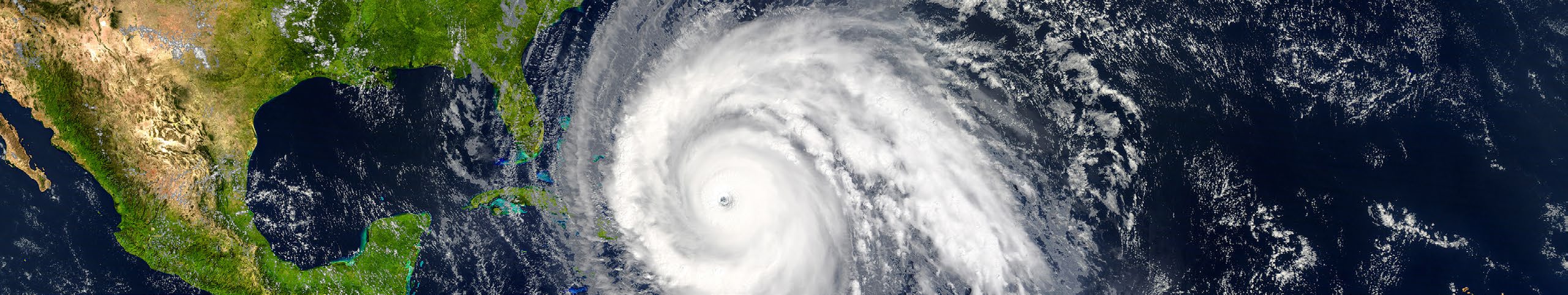
Several of these storms have affected property catastrophe interests with some impactful landfalls. Most notably, major Hurricane Idalia struck Florida in August, causing impacts across the southeast US.
The presence of El Niño conditions is known to decrease the probability of significant late-season impacts.
The property (re)insurance industry should be prepared as always for an impactful hurricane landfall regardless of the state of the season for the basin.
2023 HURRICANE RECAP TO-DATE AND OUTLOOK FOR THE NORTH ATLANTIC BASIN
Tropical Cyclone Activity to Date:
August
August featured a burst of landfalling storms in the second half of the month, with 3 impactful storms across the basin. Hurricane Franklin formed in the Caribbean and traversed across Hispañola as a tropical storm on August 23, delivering heavy rainfall and resulting flooding damage in Haiti and the Dominican Republic. Upon leaving the Caribbean, Franklin intensified into a category-4 significant hurricane and made a close approach to Bermuda at category-2 intensity. While Franklin was impacting the Greater Antilles, Tropical Storm Harold formed in the Gulf of Mexico, eventually making an August 22 landfall on Padre Island, Texas with minimal impacts.
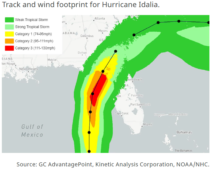
Hurricane Idalia punctuated this period of high activity, impacting Cuba and the Yucatan Peninsula as a tropical storm from August 26-29. Idalia then accelerated across the Gulf of Mexico and rapidly intensified into a category-4 significant hurricane with maximum sustained winds of 130 mph. Early on August 30, Idalia made landfall in the Big Bend region of Florida at category-3 intensity, delivering storm surge, flooding rainfall, and wind damage to the region. Tropical storm-force winds impacted much of the southeast US, but destructive hurricane force winds largely avoided major population centers, such as Tallahassee and Tampa (see figure above). As Idalia progressed inland, Georgia, South Carolina and North Carolina also experienced heavy rain and wind from the storm. Estimated insured losses to date for Hurricane Idalia range from USD 2.5 billion to USD 4 billion according to media reports from Moody’s RMS and Verisk.
2023 HURRICANE RECAP TO-DATE AND OUTLOOK FOR THE NORTH ATLANTIC BASIN
September
September featured Hurricane Lee, a long-lived and powerful hurricane that made landfall in Nova Scotia on September 17 as a category-1-equivalent frontal system (called an extratropical cyclone), bringing tropical storm conditions to eastern New England and Atlantic Canada. On September 22, Tropical Storm Ophelia formed off the southeast US, making landfall in North Carolina the following day. Finally, on October 2-3, Tropical Storm Philippe impacted the Northern Leeward Islands as a minimal tropical storm, but still brought substantial flooding to the region.
Rest of the Season
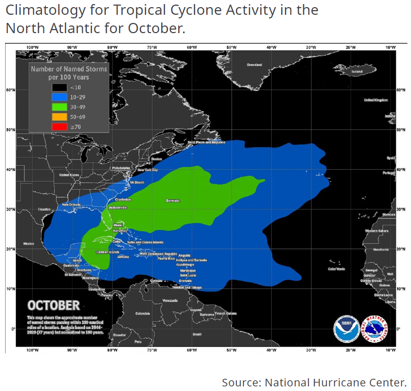
The 2023 Atlantic Hurricane Season is officially past its climatological peak of September 10-14, though tropical cyclone development is common in October. At this stage of the season, the Central Atlantic begins to cool and grow more hostile for tropical development along with increasing wind shear. As such, late season tropical cyclone development will typically occur “close to home,” often in the western Caribbean (see figure below). Proximity to land makes storms in this region a particularly high landfall threat for the mainland. As mentioned, Idalia emerged from this zone earlier this season, reinforcing that interests should closely monitor any tropical disturbances in the western Caribbean. There are several historical examples of powerful hurricanes striking the mainland from this region in October, including Hurricane Delta (2020), Hurricane Zeta (2020), Hurricane Michael (2018), Hurricane Sandy (2012), and Hurricane Wilma (2005).
2023 HURRICANE RECAP TO-DATE AND OUTLOOK FOR THE NORTH ATLANTIC BASIN
Working against October and November tropical development in the Atlantic are the current El Niño conditions. El Niño conditions increase mean wind shear over the Caribbean (changing wind speed and direction with height). This acts to pull apart developing hurricanes by removing thunderstorm activity from the center of circulation. The mid-September update from the National Oceanic and Atmospheric Administration (NOAA) Climate Prediction Center indicates that El Niño conditions will remain in place for the remainder of the hurricane season (Figure 3).
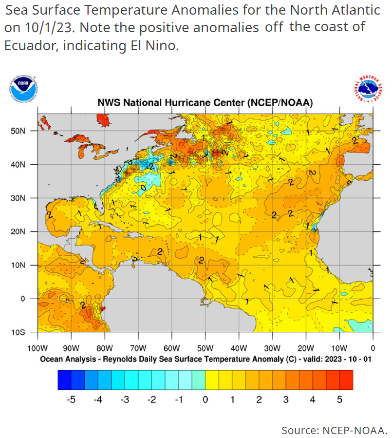
In general, the 2023 Atlantic Hurricane Season has been marked by storms developing in spite of high wind shear in the basin. Tropical disturbances have been able to leverage warm waters to develop and intensify in pockets of lower shear. The western Caribbean remains extremely warm entering October, with sea surface temperatures running 1.5-2°C above normal as of October 1 (see figure below).
The remainder of the hurricane season will come down to whether wind shear abates for long enough to allow disturbances in the western Caribbean to develop over the anomalously warm water. Recent history tells us that in October, El Niño-enhanced wind shear often emerges the victor. The strong El Niño events of 2014-2016 and 1997-1998 did not produce a single hurricane from the Western Caribbean in October or November that struck the US during the 1997, 2014 and 2015 hurricane seasons. The weaker 2009-2010 El Niño did produce Hurricane Ida in November, though this storm weakened substantially on approach to the continental US, making landfall as a tropical storm in Alabama. Furthermore, cool season climatology for El Niño includes the strengthening of the subtropical jet stream over the Southeast US and Gulf of Mexico, dramatically increasing wind shear and all but shutting down the tropical cyclone season in these regions.
Contacts
William Stikeleather |
James Waller, PhD |
| Natural Hazards Analyst | Research Meteorologist |
William.Stikeleather@guycarp.com |
James.Waller@guycarp.com |