

Meteorological Background
Michaung is the fourth tropical cyclone of the year over the Bay of Bengal. Formation of tropical cyclones in the Bay of Bengal is seasonal, with a primary peak formation during the post-monsoon season (October-December) and a secondary peak formation during the pre-monsoon season (March-May).
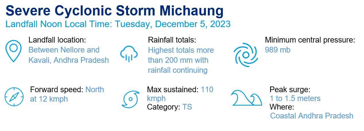
The severe cyclonic storm Michaung developed over the west central Bay of Bengal on December 3. It progressed along the south coast of Andhra Pradesh and made its landfall from 12:30 to 2:30 p.m. Indian Standard Time (IST), close to the south of Bapatla on December 5, with a maximum sustained wind speed of 90-100 kmph. Track forecasts suggest the storm will trend northward and weaken within 12 hours of landfall with maximum wind speeds falling below 60 kmph. It is expected to become a depression with maximum sustained surface wind speeds of below 60 kmph by 5:30 a.m. IST on December 6.
Observed Wind Speeds and Rainfall
Gale wind speeds were observed (4:30 p.m. IST on December 5) reaching 90-100 kmph and gusting to 110 kmph across the west-central Bay of Bengal, as well as along and off the south coast of Andhra Pradesh. Rainfall warnings are in place for coastal Andhra Pradesh, Telangana, Odisha, Chhattisgarh, Rayalaseema and north coastal Tamil Nadu, with exceptionally heavy rainfall likely over coastal Andhra Pradesh and Yanam, as well as central districts of coastal Andhra Pradesh.
Observed rainfall (8:30 a.m. IST on December 4 to 7:30 a.m. IST on December 5) was recorded at the following locations:
| Location | Rainfall (mm) |
| Bapatla | 215.3 |
| Nellore | 215.1 |
| Machilipatnam | 151.7 |
| Kavali | 143.6 |
| Ongole | 117 |
| Kakinada | 77.6 |
| Narsapur | 60.7 |
Storm Surge
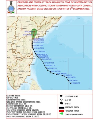
Storm surge of up to 1.1 meter above astronomical tide is likely to inundate south coastal Andhra Pradesh districts at the time of landfall.
Most likely the districts impacted would be Krishna, Prakasam, Guntur and Nellore in Andhra Pradesh, and Thiruvallur in Tamil Nadu.
Flash Flood
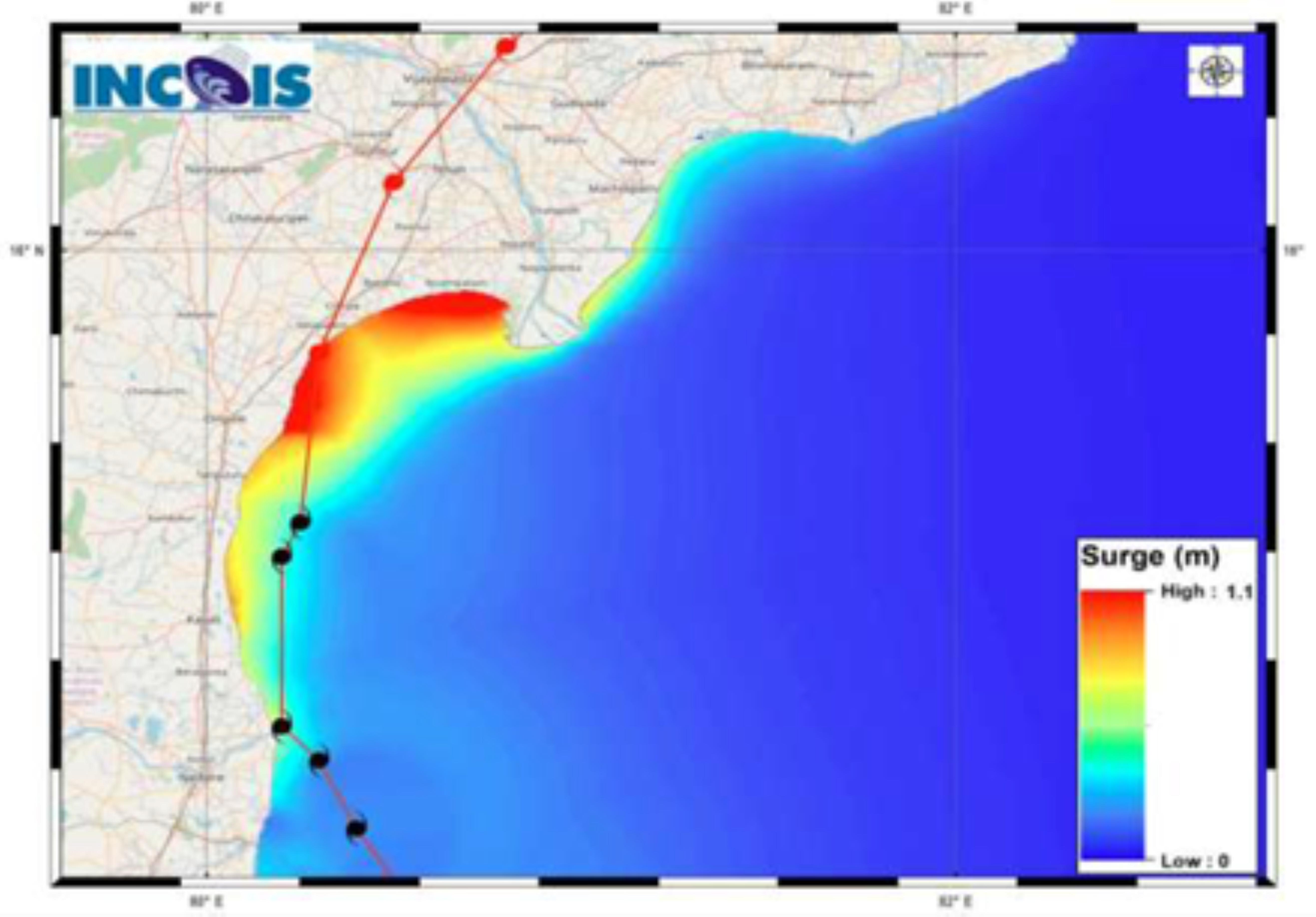
Expected moderate to high flash flood risk likely over a few watersheds and neighborhoods of the southern part of coastal Andhra Pradesh, the southeast part of Rayalaseema and northern part of Tamil Nadu–Pudu and Karaikal.
Surface runoff/inundation may occur in some low-lying areas as shown in the map, due to expected rainfall occurrence.
Impact
Damage is expected over coastal districts of South Andhra Pradesh (Nellore, Tirupati, Prakasam, Bapatla, Guntur, Krishna and West Godavari) and adjoining coastal districts of North Tamil Nadu-Puducherry.
The India Meteorological Department has included damage indications to various structures and plantations in their advisory bulletins. Major damage was indicated to thatched houses/huts, with breaking of tree branches and uprooting of large avenue trees. Minor damage to power and communication lines occurred due to breaking of branches and uprooting of trees. Damage was expected to impact paddy crops, horticultural crops and orchards. Inundation was also expected in the low-lying areas in coastal districts, due to heavy rainfall and flash floods.
Heavy rains associated with cyclone have affected the city of Chennai. According to the Greater Chennai Police, 5 deaths have been reported owing to various reasons, including falling of trees and electrocution. Most of the flights from Chennai International Airport were canceled or delayed due to heavy rainfall. Chennai’s municipal administration considered that these are the worst rains the city has seen in the last 70-80 years.
Sources: Indian Meteorological Department (Ministry of Earth Science); The Weather Company, Reuters, Indian Express