
In the past year, the scientific community has been actively drawing lessons from the Kahramanmaras earthquakes. There is now greater clarity of the earthquake mechanism, local geotechnical characteristics and structural vulnerability. In this CAT Resource Center briefing, Guy Carpenter reports on findings from some recent research publications.

Introduction
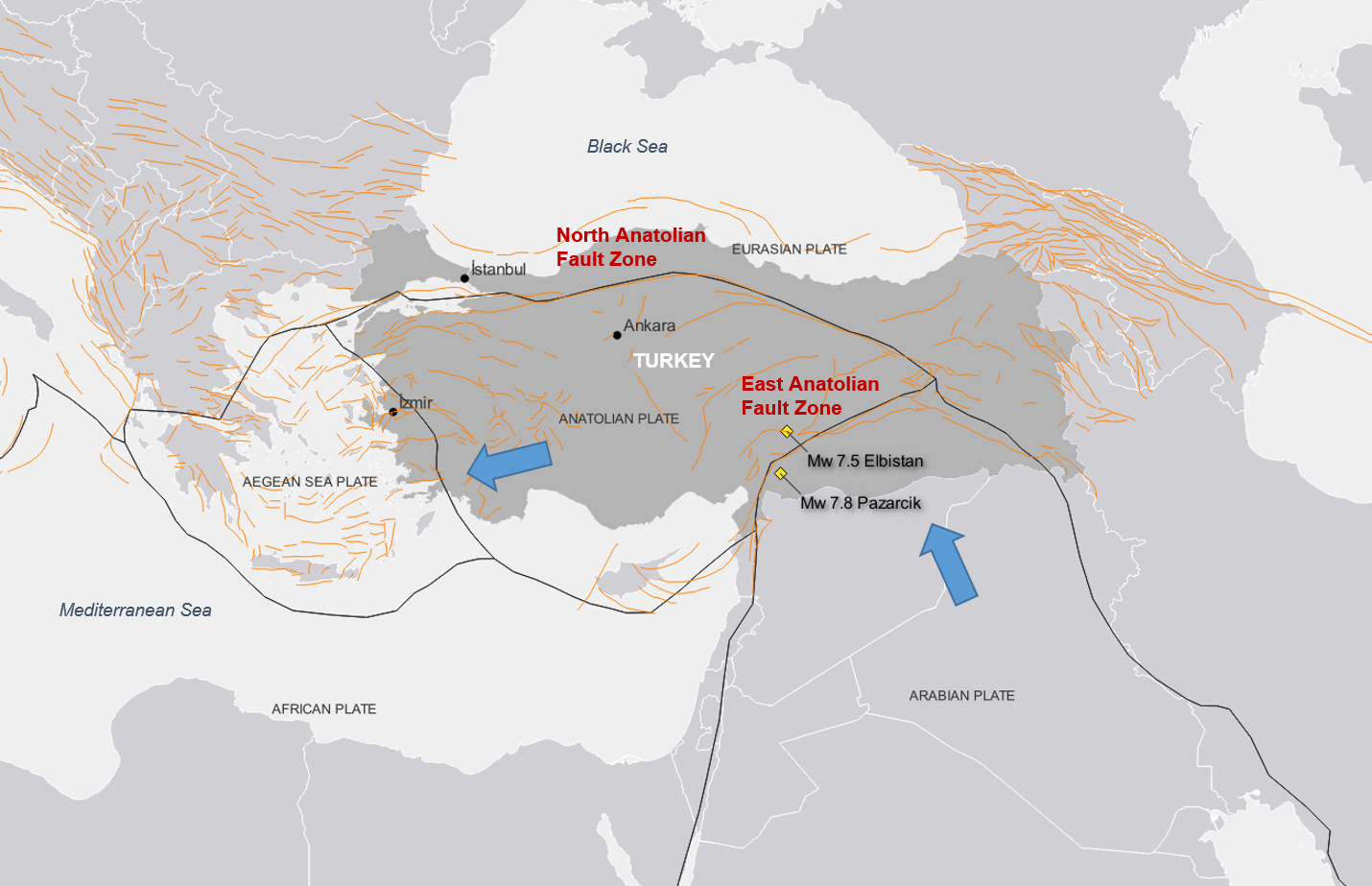
On February 6, 2023, southern Turkey was struck by 2 large earthquakes (Mw 7.8 and Mw 7.5) in the space of 9 hours, both with epicenters close to the city of Kahramanmaras.
Figure 1: Maximum shaking intensity across both major earthquakes.
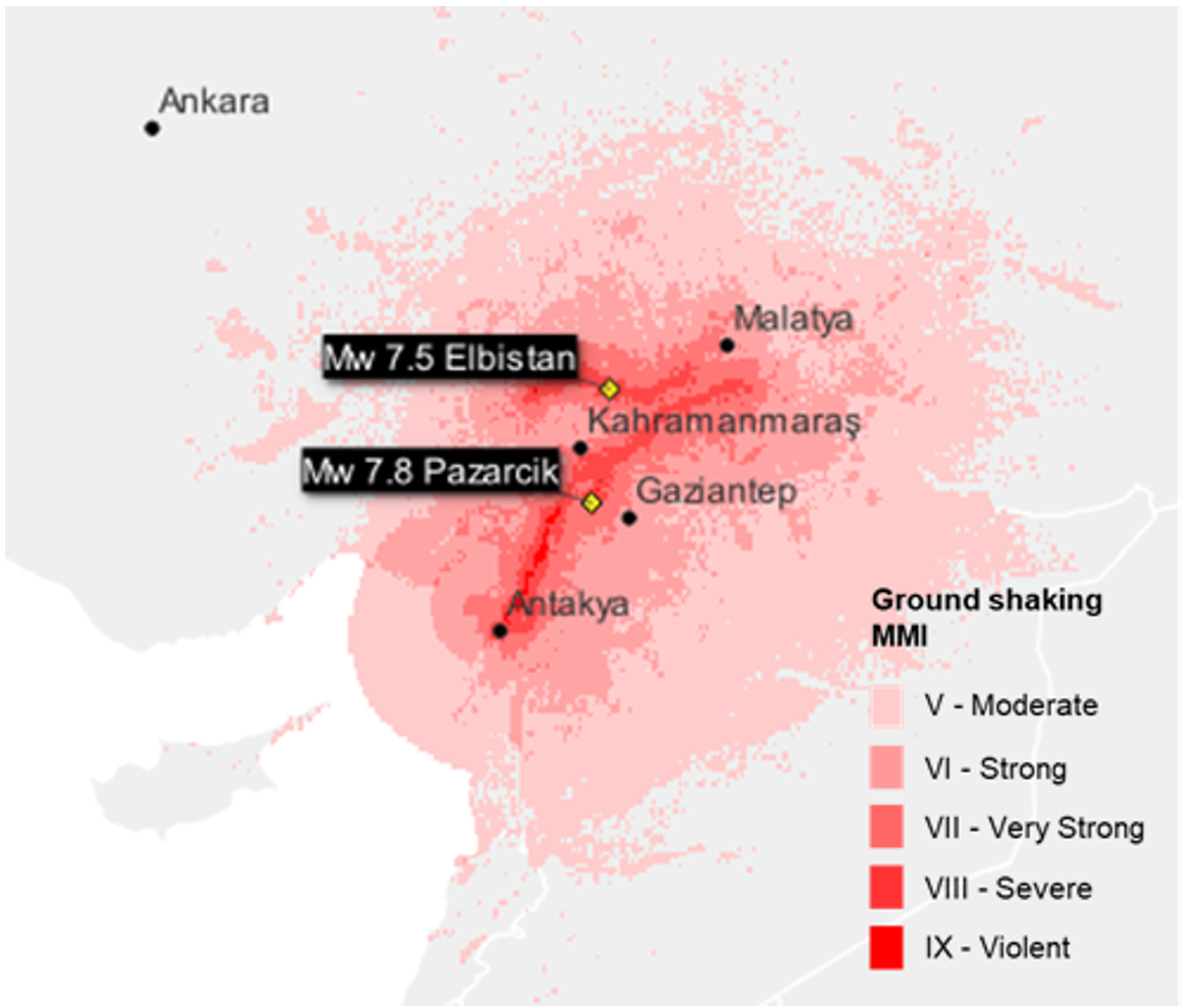
Source: U.S. Geological Survey; Graphics: Guy Carpenter.
On the first anniversary, Guy Carpenter summarizes some of the lessons learned from these earthquakes by the scientific community.
Key observations from the studies include:
- Basin effects in the impacted region played a significant role in amplifying the ground shaking.
- Directivity also added to local ground shaking.
- The roughly east-west orientation of the fault segments in the Marmara Sea means it is unlikely for directivity to have a significant impact for Istanbul in the north.
- Studies show the likelihood of 2 large earthquakes so close to each other in location and magnitude is low.
- Seismic station recordings showed that in some cases accelerations from these low-frequency waves exceeded the 2018 building code design requirements.
- Experimental testing of concrete samples collected from collapsed buildings after these earthquakes showed that their compressive strength was lower than the average determined from concrete samples collected from other studies in Istanbul.
Damage Impact
The Turkey Disaster and Emergency Management Authority reported more than 50,000 fatalities, with 115,000 people injured and more than 528,000 people evacuated.
The 2023 Kahramanmaras and Hatay Earthquakes Report [1] estimated that the total burden of the disaster on the Turkish economy is TRY 2 trillion[2], which could amount to 9% of projected 2023 GDP. It also showed that as of March 6, 2023, damage assessment over 1,712,182 buildings across 11 provinces found 35,355 collapsed buildings, with an additional 17,491 structures identified for urgent demolition. Furthermore, 179,786 buildings were severely damaged, 40,228 were moderately damaged and 431,421 experienced light damage. Beyond residential buildings, the earthquakes adversely affected historic and cultural structures, schools, hospitals and administrative buildings, resulting in total collapses or significant damage.
The report attributed 54.9% of the TRY 2 trillion loss to damaged housing units, and 12.1% to destruction of public infrastructure and public service buildings. The damage incurred by the private sector other than housing was estimated at 11.1%. This includes manufacturing industries, energy, communications, tourism, healthcare, education, small tradespersons and houses of worship. As of February 6, 2024, PERILS estimated that the industry loss is TRY 117 billion, which includes Turkish Catastrophe Insurance Pool (TCIP) losses. In total, about 5% was insured out of TRY 2 trillion sustained in economic damage. As of a January 3, 2024 press release, DASK, Turkey’s national disaster insurance institute, reported that TCIP had paid TRY 35 billion.[3]
Hazard
While much of the discussion on this earthquake sequence has focused on building performance, it has also been notable within the scientific community for its seismological characteristics. In particular there are 2 features, basin effects and directivity, which may have played a major role in the scale and severity of the observed damage.
Basin Effects
Some of the most severe ground shaking and subsequent builiding damage was observed in Hatay province, especially in the area around the Antakya Basin (part of the larger Amik Basin, shown in Figure 2), which lies underneath the city of the same name. Geological basins such as these are formed from drained lake beds and are characterized by deep deposits of soft soil, which amplify the intensity of ground shaking caused by earthquakes, known as basin effects. Some studies suggest that in parts of Antakya city, amplification could more than double the ground shaking intensity.[4] Due to the nature of the soft soil found here, this amplification is most pertinent to the performance of medium- and high-rise buildings.
The existence of the Antakya Basin and its potential amplifying effects are known within the scientific community.[5,[6] Commercial vendor models do typically consider amplification due to surface soil conditions, but basin effects refer to much deeper layers of soft soils. Basin models are highly complex and require significant resources to develop and integrate into commercial risk models. Consequently, model vendors have prioritized their resources in cities where insured exposure and risk are perceived to be higher (e.g., Beijing, Los Angeles, Lima). In the absence of modeled solutions, Guy Carpenter has developed its own view on the extent to which ground shaking intensity is potentially underestimated in the Antakya Basin area.
Figure 2: Location of the Amik and Antakya basins relative to Antakya city.
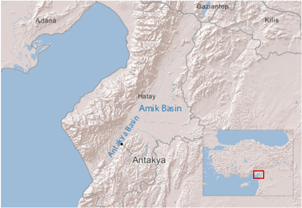
Source: Geodinamica Acta [7]; Graphics: Guy Carpenter.
It should be emphasized that basin effects occur as a result of local conditions, and it is not expected that it would be observed in other regions in Turkey. For example, the geology around Istanbul and the Marmara Sea is very different and while some amplification due to surface soil conditions is possible, it is unlikely that it would occur at the scale observed in the 2023 earthquakes.
Directivity
This describes the effect where ground shaking intensity is stronger in the direction along which a fault ruptures than in other directions. It occurs at sites close to a fault rupture, when the rupture propagates toward the site and the direction of fault slip is in line with the site. In the case of the first Kahramanmaras earthquake, the fault ruptured in a southwesterly direction from the epicenter toward Hatay, which is where the strongest ground shaking was observed.
Directivity is associated with large earthquakes, which tend to rupture gradually rather than instantaneously. Usually, large faults rupture at speeds slower than the seismic waves they generate. However, the closer the rupture speed is to the seismic wave speed, the more likely the waves are to reinforce each other, generating large-amplitude, pulse-like ground motions. The presence of pulse-like ground shaking in the first earthquake has been documented[8] and has been implicated as a significant factor in the scale of damage observed in Hatay.[9] This effect particularly occurs for low-frequency seismic waves, which are most impactful for tall buildings.
Some studies have suggested that the rupture propagation speed in the first earthquake may even have exceeded the seismic wave speed, making it a supershear earthquake.[10] In this scenario, the seismic waves catch up with one another to create a single large wave that is the seismological equivalent of a sonic boom. This has the potential to generate stronger ground shaking, not only close to the fault, but also at more distant sites and could further increase the likelihood of damage.[11]
Historically, the models used in seismic hazard assessment to estimate ground shaking intensity (known as ground motion models) have not considered the impact of the directivity. However, newer ground motion models have started to include components that allow directivity effects to be captured to some degree. Nevertheless, given the specific conditions required for directivity effects to occur, there remains significant uncertainty in whether these effects will happen for a particular event, and if they do, with what severity.
While it could occur on other large earthquakes elsewhere in Turkey in the future, it is rare for it to be observed with the severity seen last year. In order to capture these types of scenarios in catastrophe models, very large event sets would be required to reflect the uncertainty in severity while maintaining appropriate event frequencies.
In the case of Istanbul, hazard is driven by the North Anatolian Fault. Since it is a strike-slip fault, the likelihood of directivity occurring is elevated. However, the roughly east-west orientation of fault segments in the Marmara Sea (the section closest to the city) means that even if directivity did occur, it would be unlikely to have a significant impact on the metropolitan area of Istanbul in the north.
Earthquake Sequences
In addition to basin effects and directivity, another factor that contributed to the scale of the observed damage is how close these 2 large earthquakes were in both space and time. Not only did this increase the total number of buildings exposed to damaging levels of ground shaking, but the footprints of the 2 earthquakes overlapped—meaning that some buildings were hit by strong shaking in both earthquakes.
Furthermore, in cases where bulidings were hit twice, it is possible that some may not have experienced significant damage in the first earthquake but were left in a weakened state, increasing their vulnerability to the effects of the second earthquake. Since commercial catastrophe models (and probabilistic seismic hazard assessments more generally) do not model earthquake sequences, the concept of progressive damage across multiple earthquakes is not explicitly captured. The Kahramanmaras earthquakes, along with other recent events in New Zealand (2010-11) and central Italy (2016), have increased interest in earthquake sequences and the potential for progressive damage. The integration of earthquake sequences into seismic hazard assessment remains an active area of research,[12] which Guy Carpenter is following closely.
However, it is important to note that the likelihood of 2 such large magnitude earthquakes, striking so close to one another, remains very low. Guy Carpenter’s own analysis of earthquake sequences from the US Geological Survey (USGS) earthquake catalog (1979-2019), shows that fewer than 10% of sequences included a second earthquake that was within 0.3 magnitude units of the largest earthquake, as shown in Figure 3.
Figure 3: Distribution of magnitude differences in earthquake sequences from USGS catalog.
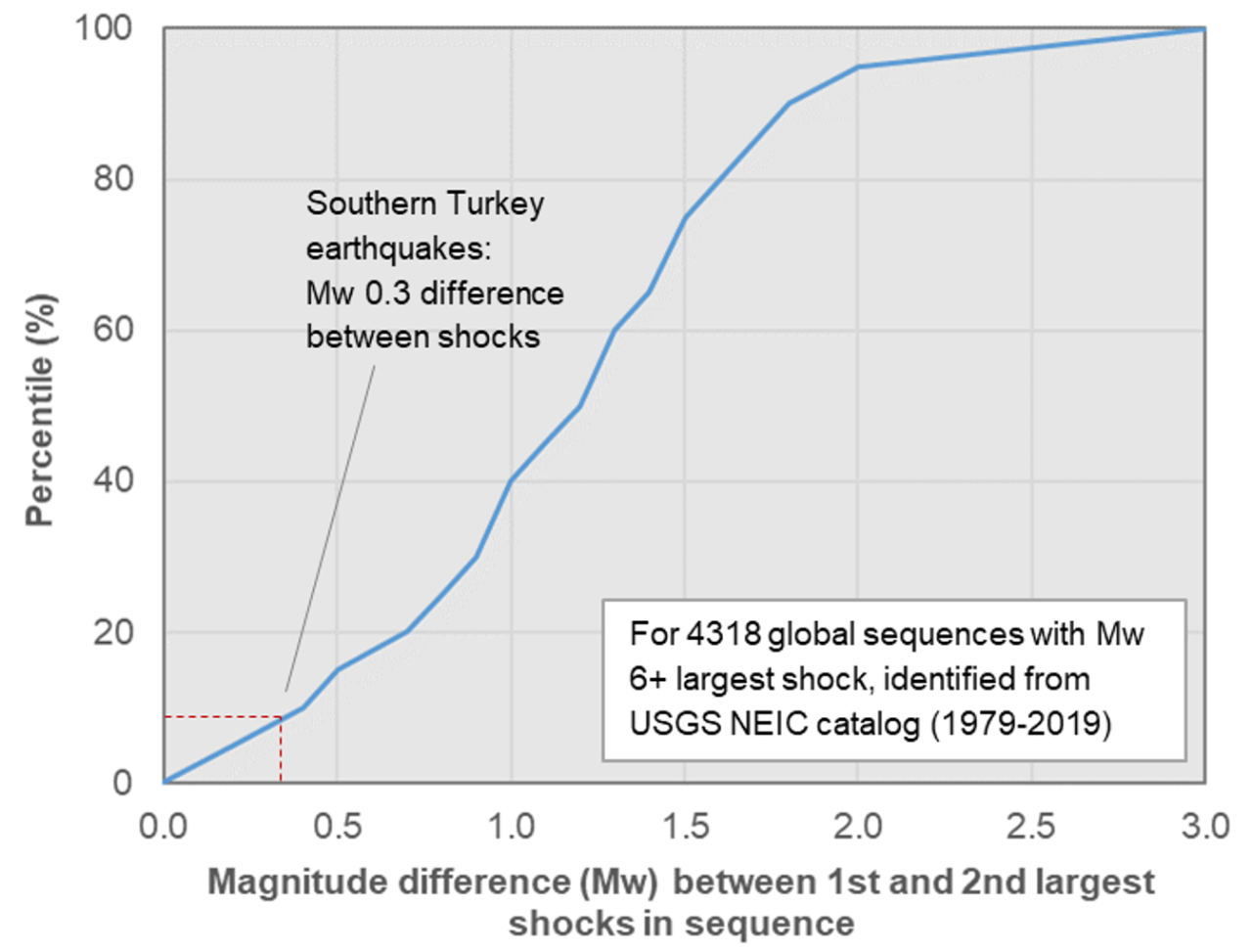
Source: USGS Catalog; Graphics: Guy Carpenter.
Vulnerability
The 2023 earthquake sequence was one of the largest loss-causing natural catastrophe events in Turkey in recent history. A number of factors contributed to the scale of damage that was observed, including the severity of the ground shaking, the number of urban centers in close proximity to the fault ruptures and the vulnerability of the building stock.
Seismic design guidelines in Turkey are established in the Turkish Earthquake Code, first published in 1975, with subsequent updates in 1998, 2007 and 2018. The shortcomings of the original 1975 code are well-documented,[13] but the 1998 update brought the code in line with the Uniform Building Code, used widely in the US at the time. Later updates ensured that the Turkish code remained in line with best global practices. It has been reported based on field studies that the vast majority of building collapses (up to 97%[12]) were observed in pre-2000 building stock,[14] underlining both the shortcomings of the original code and the rigor of the codes from 1998 onward.
However, as has been widely reported, some collapses were also observed in modern building stock. There are many reasons why a building designed to the latest codes may not have performed as expected. Among these are the influence of ground shaking amplification, particularly in Hatay, which should not be underestimated.
As discussed in the previous section, basin effects and directivity are 2 factors that amplified the ground shaking intensity, particularly for low-frequency waves, which mostly affect taller structures. There is evidence from seismic station recordings that in some locations, the accelerations from these low-frequency waves exceeded the design requirements set out in the 2018 building code.[15]
Consideration is also being given as to whether observations from these earthquakes are likely to be repeated in other parts of the country. Experimental testing of concrete samples collected from collapsed buildings after these earthquakes has shown that their compressive strength was lower than the average determined from concrete samples collected in Istanbul in an earlier study.[4] Furthermore, a recent study on the 2020 Elazig and Izmir earthquakes showed that for the same building types, there was a clear difference in reported damage across the 2 regions, with significantly lower damage being reported in Izmir.[16] Studies of construction practices by region is an area of ongoing research.
Summary
In this document, we highlight the impact from basin effects, directivity, temporal and spatial proximity of large earthquakes in a sequence, and structural vulnerability to the damages. Furthermore, we emphasize that these characteristics differ by region.
The Kahramanmaras earthquakes are still under active research, which is likely to lead to improvements in risk management. Considering the losses, TCIP increased its maximum policy limit from TRY 640,000 to TRY 1,272,000 with an inflation clause, as of January 1, 2024. Findings on the hazard, vulnerability and financial loss will inform government, risk bearers and model developers as they improve structural and financial resilience for local communities.
2023 KAHRAMANMARAS EARTHQUAKES: FIRST ANNIVERSARY
References
[1] 2023 Kahramanmaras ve Hatay Depremleri Raporu by T.C. Cumhurbaşkanlığı Strateji ve Bütçe Başkanlığı
[2] TRY 1 = EUR 0.049348 = 0.053102 Source: OANDA FX Rates © OANDA Corporation, 6 February 2023, daily mid-market rates.
[3] TarifeGuncelleme Bulten of 281223 by DASK Press Release on January 3, 2024
[4] Altunsu, E., Gunes, O., Ozturk, S., Sorosh, S., Sari, A. and Beeson, S.T. (2024). Investigating the structural damage in Hatay province after Kahramanmaras-Turkiye earthquake sequences, Engineering Failure Analysis, 157, 107857.
[5] Over, S., Buyuksarac, A., Bekta, O. and Filazi, A. (2011). Assessment of potential seismic hazard and site effect in Antakya (Hatay Province), SE Turkey, Environmental Earth Sciences, 62, pp. 313-326.
[6] Cakti, E., Bikce, M., Ozel, O., Genes, C., Kacin, S. and Kaya, Y. (2011). Antakya basin strong ground motion network, Geophysical Research Abstracts, Vol. 13, EGU2011-10705
[7] Tari, U., Tuysuz, O., Genç, Ş., Imren, C., Blackwell, B., Lom, N., Tekesin, O., Uskuplu, S., Erel, L., Altiok, S., Beyhan, M. (2013). The Geology and Morphology of the Antakya Graben between the Amik Triple Junction and the Cyprus Arc, Geodinamica Acta, Vol 26 – Issue 1 -2 : Tectonics of the Eastern Meditterranean – Black Sea Region: Part B, pp. 27-55.
[8] Wu, F., Xie, J., An, Z., Lyu, C., Taymaz, T., Irmak, T.S., Li, X., Wen. Z. and Zhou, B. (2023). Pulse-like ground motion observed during the 6 February 2023 Mw 7.8 Pazarcik Earthquake (Kahramanmaras, SE Turkiye), Earthquake Science, 36, pp. 328-339.
[9] Kazaz, I., Bilge, I.H. and Gurbuz. M. (2024). Near-fault ground motion characteristics and its effects on a collapsed reinforced concrete structure in Hatay during the February 6, 2023 Mw 7.8 Kahramanmaras earthquake, Engineering Structures, 298, 117067.
[10] Wang, Z., Zhang, W., Taymaz, T., He, Z., Xu, T. and Zhang, Z. (2023). Dynamic Rupture Process of the 2023 Mw 7.8 Kahramanmaras Earthquake (SE Turkiye): Variable Rupture Speed and Implications for Seismic Hazard, Geophysical Research Letters, 50, e2023GL104787.
[11] Karthik Reddy, K.S.K., Veggalam, S. and Somala, N. (2022). Spatial variation of structural fragility due to supershear earthquakes, Structures, 44, pp. 389-403.
[12] Altindal, A. and Aysegul, A. (2024). Traditional seismic hazard analyses underestimate hazard levels when compared to observations from the 2023 Kahramanmaras earthquakes, Communications Earth & Environment, 5:14.
[13] Binici, B., Yakut, A., Kadas, K., Demirel, O., Akpinar, U., Canbolat, A., Yurtseven, F., Oztaskin, O, Aktas, S. and Canbay, E. (2023). Performance of RC buildings after Kahramanmaras Earthquakes: lessons toward performance-based design, Earthquake Engineering and Engineering Vibration, 22, pp. 883-894.
[14] Mertol, H.C., Tunc, G., Akis, T., Kantekin, Y. and Aydin, I.C. (2023). Investigation of RC Buildings after 6 February 2023, Kahramanmaras, Turkiye Earthquakes, Buildings, 13, 1789.
[15] Vuran, E., Serhatoglu, C., Omer Timuragaoglu, M., Smyrou, E., Bal, I.E. and Livaoglu, R. (2024). Damage observations of RC buildings from 2023 Kahramanmaras earthquake sequence and discussion on the seismic code regulations, Bulletin of Earthquake Engineering, https://doi.org/10.1007/s10518-023-01843-3
[16] Acikgoz, N. and Hancilar, U. (2022). Derivation of Empirical Fragility Curves for Turkey, 3rd European Conference on Earthquake Engineering & Seismology.
Contacts
Global Strategic Advisory
Seval Cakir Indranil Kongar, EngD
seval.cakir@guycarp.com indranil.kongar@guycarp.com
Francois Dagneau, FCAS, FCIA Matthew Eagle
francois.dagneau@guycarp.com matthew.eagle@guycarp.com
Broking
Songul Demir Mary Lyng