

At the start of February, the academic journal Proceedings of the National Academy of Sciences (PNAS), released a new publication by Michael Wehner and Jim Kossin, which showed a significant increasing trend in the number of category 5 hurricanes during the satellite era.
An Upward Trend in the Strongest Hurricanes
1. Satellite Era Observations (1980-2021)
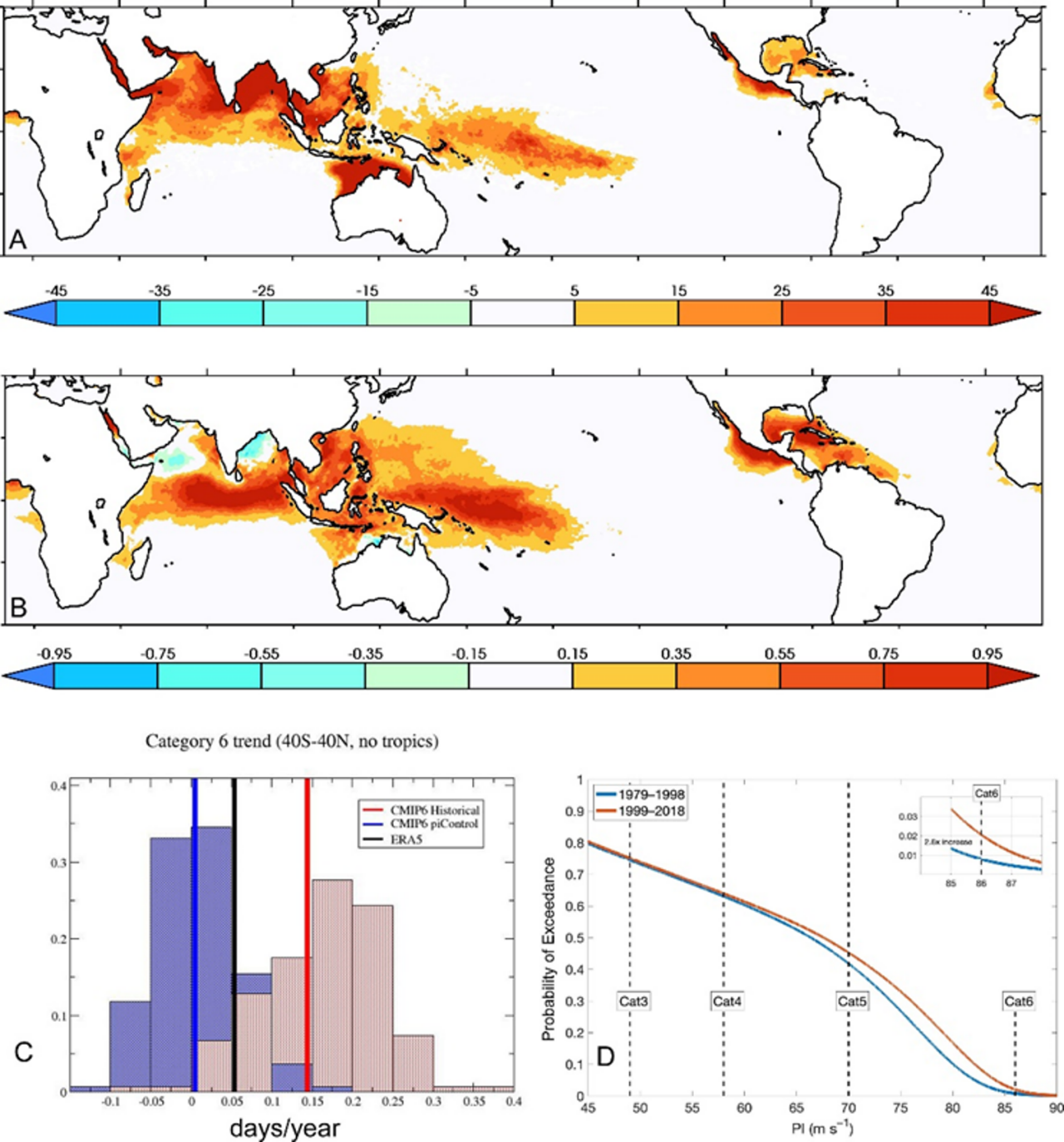
Wehner and Kossin highlighted that, "97 tropical cyclones (TCs) that were classified as category 5 during the 42-year period 1980 to 2021, which comprises the period of highest quality and most consistent data, [and] half of them occurred in the last 17 years of the period. Five of those storms exceeded our hypothetical category 6 [>192 mph] and all of these occurred in the last 9 years of the record."
Their findings align with several other research publications but the suggestion that the top-end of the Saffir-Simpson wind scale might need to be extended to higher wind speeds (category 6) has received a lot of attention in the climate science media. This is not a new suggestion (e.g. 2014 publication and 2018 news article) but with the additional years of data presented in this research, the significance of the trend increases.
2. Category 6?
But what is a category 6? You might not be familiar with this category rating because it does not exist. The current scale stops at category 5, but with the more frequent exceedance of the category 5 hurricane threshold (>157 mph) by large margins, the paper suggests that 192 mph should be the new starting point for category 6 hurricanes (Figure 1).
Although the intent of the paper was to highlight the effect of global warming on the most intense TCs, many scientific and non-scientific audiences have discussed the ramifications of how stronger storms may influence how hurricane warnings could evolve. The authors have made it clear, “The motivation for the paper was emphatically not to propose adding a category to the Saffir-Simpson scale, but rather to use the hypothetical category 6 as a tool for discussing how best to communicate risk as tropical cyclones become more intense over time.”
Environmental Support for Stronger Hurricanes
Theoretical Upper Limit for Hurricane Intensity Increasing Globally
The paper showed that the increase in potential intensity in tropical regions during the past 4 decades (1979 to 2019) supports the observed increase in the strongest storms. In a nutshell, potential intensity is the theoretical limit of the strength of a TC based on the temperature at the surface (e.g. ocean surface) of the storm and upper levels of the troposphere (cold tops of clouds).
They also examined the recent IPCC report’s suite of climate models (CMIP6 multimodel intercomparison) simulations both with and without anthropogenic (greenhouse gases and aerosols) forcing for that same time interval (bias-corrected based on the reanalysis data). The simulations suggest a detectable influence of anthropogenic forcing on the potential intensity values that could harbor these hypothetical category 6 hurricanes. These results agree well with other recent publications (e.g. Figure 6 and Figure 5).
Caveats
- Although potential intensity appears to be the best predictor of TC intensification for forecasting TCs in real-time, an increase in the theoretical ceiling for hurricane intensity does not necessarily translate to more intense storms, especially with all the important dynamical factors (wind shear, mean steering winds, etc.) that affect TCs.
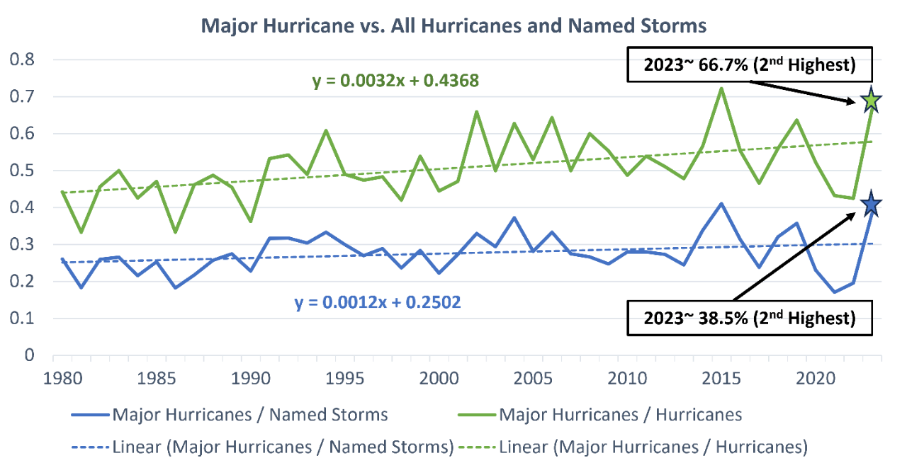
- The observed significant increase in the proportion of TCs that become major hurricanes does not correlate with changes in overall frequency or landfall frequency.
- Finally, the study focuses on the satellite era where there are fewer inconsistencies in observations than earlier in the historical record. However, there still are some changes in observational techniques for different basins and years during this period, which could introduce uncertainty in the intensity measurements during this time period.
Even with these caveats, there is a detectable signal in global data that once a TC forms, it has a higher probability of becoming stronger (Figure 2). One of the more confident climate change signals on TCs centers around this conclusion and agrees with the Kossin and Wehner results. The emergence of a significant trend in any TC metric at the global scale is noteworthy because the current scientific consensus is that natural climate variability cannot modulate TC behavior at the global scale.
Conclusions
Arguably, the most important message of this new research is that the trend in the proportion of intense hurricanes over the last 40+ years has a growing tail (in risk speak, the top end of the distribution). The paper shows an increase in the intensity ceiling of hurricanes and there is growing evidence that suggests this trend will continue. The relationship between damage and wind speed is non-linear which broaches several questions:
- What would loss from a category 6 landfall look like?
- Is such a landfall possible for the US in the near future?
- What can we do to prepare for it?
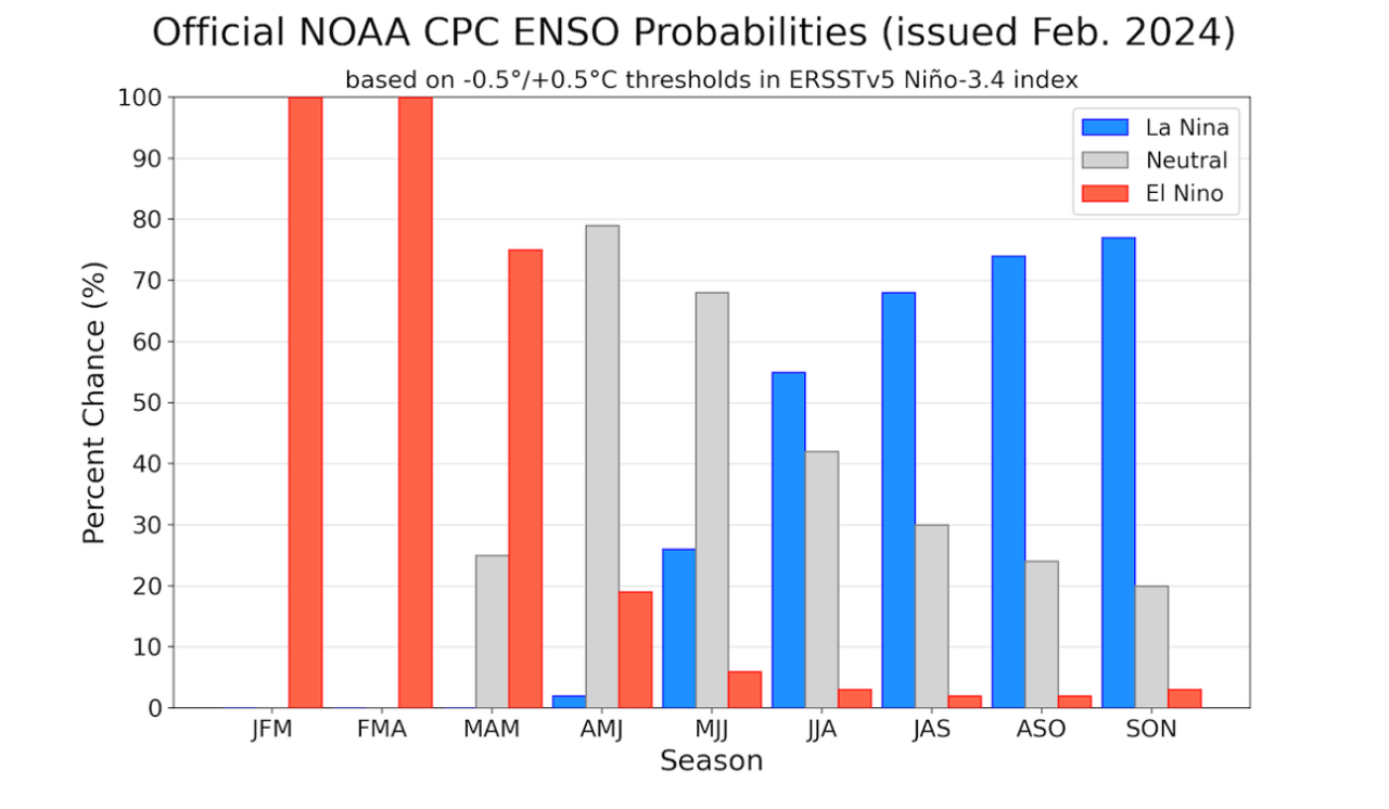
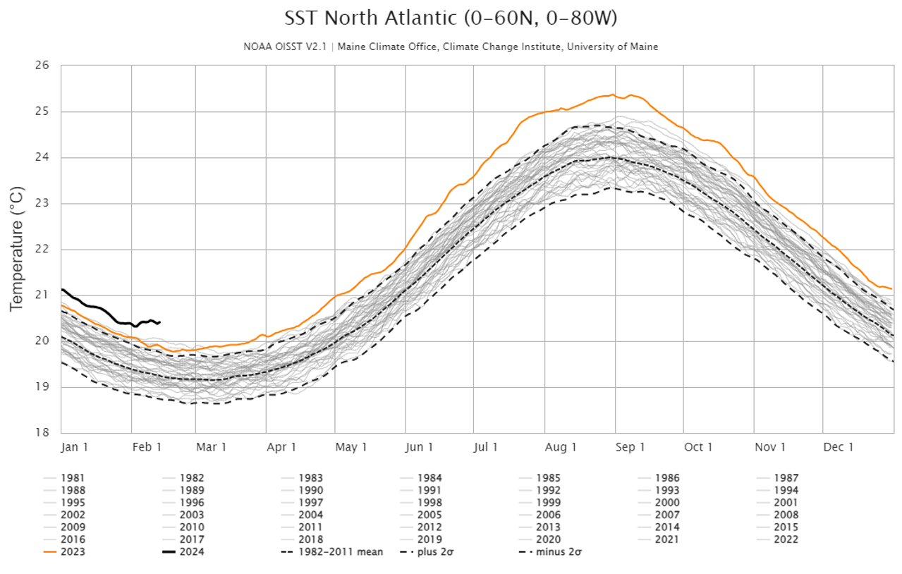
Wehner and Kossin bring these questions to the front of mind as we look ahead to the 2024 North Atlantic basin hurricane season with a forecasted change to La Niña during peak season (Figure 3) and record-breaking sea surface temperatures in the North Atlantic (Figure 4). A lot can change between now and the peak season but a transition to La Niña and above average ocean temperatures would point to more TC activity in the North Atlantic and increased potential for the strongest hurricanes.
Download Thought Leadership: Climate Change and "Category 6" Hurricanes
Questions or feedback? Please contact Kieran Bhatia, Climate and Sustainability Lead for North America, Guy Carpenter