
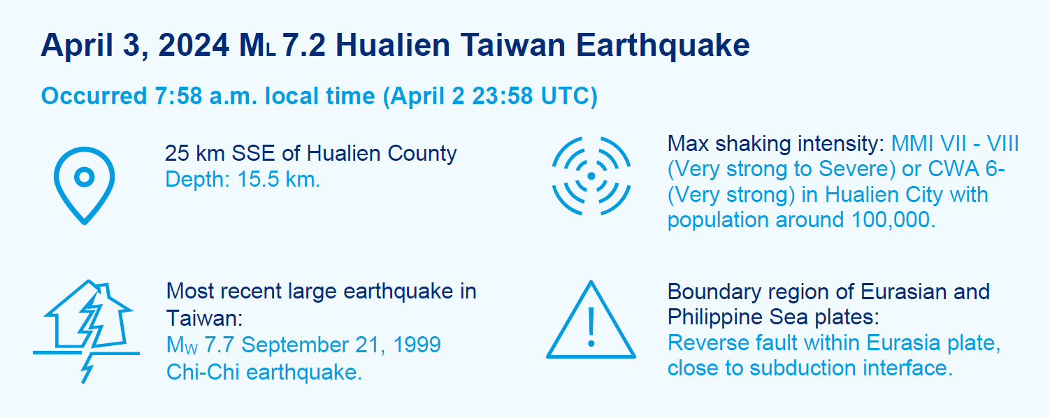
- A strong ML 7.2 (Mw 7.4) earthquake occurred 25 km off the shore of the Hualien County in the morning hours of April 3. The Taiwan Central Weather Administration (CWA) reported the strongest shaking intensity of 6- on the CWA scale in Hualien City, population around 100,000.
- The April 3 earthquake is the largest event in Taiwan since the Chi-Chi Earthquake on September 21, 1999.
- More than 240 aftershocks M ≥ 4 were recorded in the first 5 days, with most of them north of the epicenter of the main shock.
- At the time of this writing, 15 fatalities have been reported.
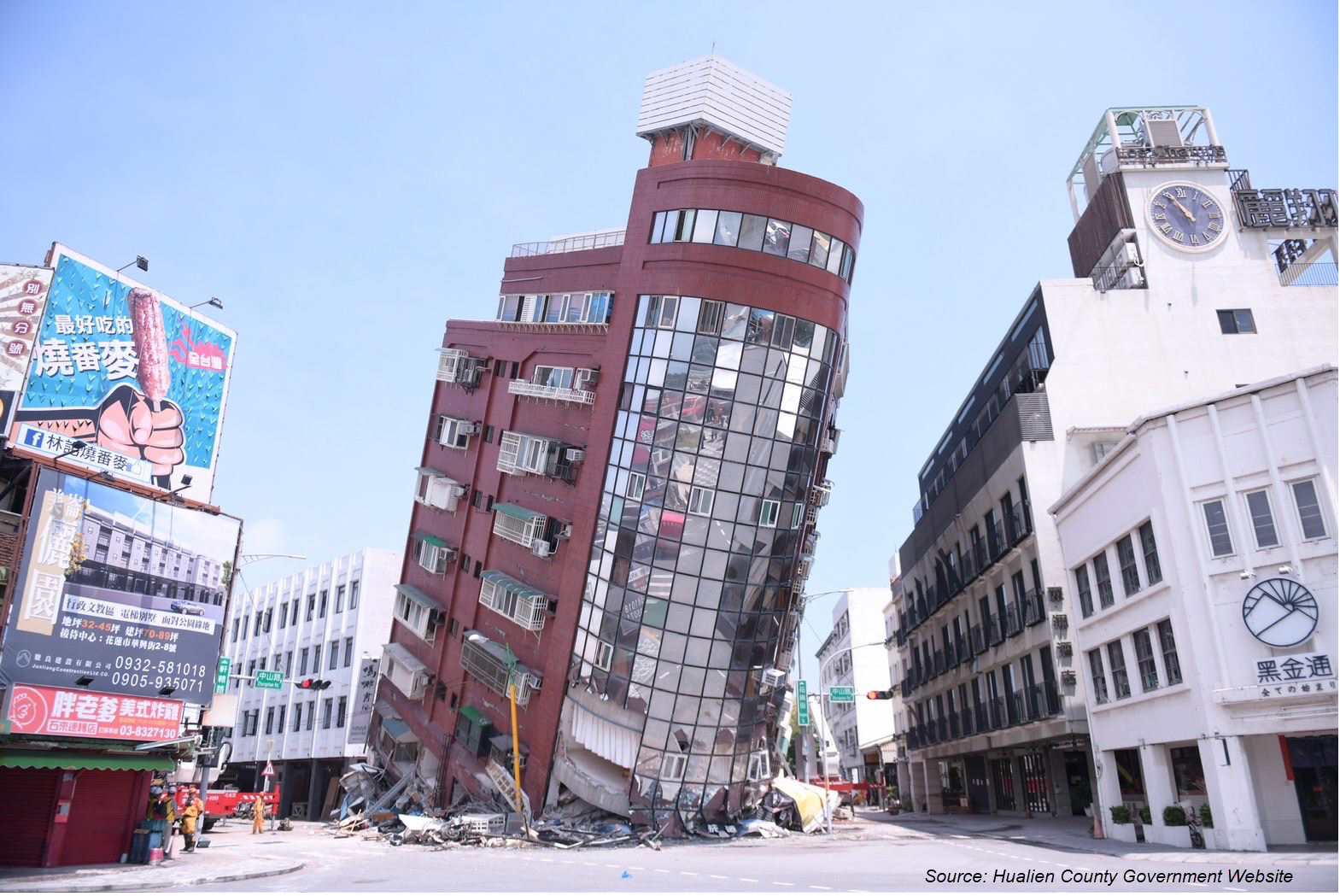
- Damage from ground shaking has been most severe in Hualien County. Moderate damage was observed in the north, in Yilan County, Taipei, New Taipei, Keelung and Taoyuan.
- Secondary impacts were also reported, due to falling rocks, subsidence, landslide, and fire.
The Hualien Taiwan Earthquake post-event report comprises the following sections:
- Physical Discussion of the Earthquake
- Seismotectonic Context
- Damage Impacts
- Comparison with Historical Events
Physical Discussion of the Earthquake
This ML 7.2 (MW 7.4) earthquake, the largest in Taiwan for 25 years, occurred at 7:58 a.m. local time on Wednesday, April 3, 2024, off the island’s east coast, about 25 km south-southeast of the Hualien County. The earthquake was relatively shallow, with a depth of 15.5 km, and occurred on a reverse fault with a northeast-southwest orientation. It was estimated that the fault ruptured over an area of around 60 km by 35 km.
The Taiwan Central Weather Administration (CWA) reported shaking intensity up to 6- (Very strong) on the CWA scale, the third-strongest category possible. Figure 1 shows the CWA intensity at seismic recording stations across Taiwan. This illustrates the directivity of the fault rupture, which started at the epicenter and ruptured nearly unilaterally to the north/northeast. Strong directivity, combined with reflection of seismic waves against the mountainous topography of the region, resulted in more damage north of the epicenter. In addition to ground shaking, the terrain and ground conditions in this region of Taiwan contributed to numerous incidences of liquefaction in coastal areas and landslides in the mountains and coastal cliffs.
Figure 1: CWA recorded ground shaking intensities of the ML 7.2 Hualien Earthquake (7:58 a.m. local time).
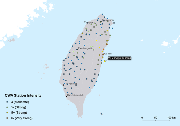
Source: Central Weather Administration, Graphics: Guy Carpenter
The US Geological Survey (USGS) reported that on the Modified Mercalli Intensity (MMI) scale, this earthquake reached between MMI VII (Very strong) and VIII (Severe). The USGS PAGER system estimated that almost 20 million people were exposed to at least MMI V (Moderate), which is the level at which structural damage starts to be observed. The USGS ground-shaking intensity footprint (v8) for this earthquake is shown in Figure 2.
It should be noted that USGS footprints are simulated based on observations from seismic recording stations and damage reports combined with models of ground motion extents, so some uncertainty remains. The USGS simulated footprint estimates a peak ground acceleration of 0.30g in the city of Hualien. The Global Earthquake Model estimates that this level of shaking is expected in Hualien city approximately every 15-20 years (based on hazard data from the latest Taiwan national seismic hazard model, TEM 2020).
Figure 2: USGS simulated ground shaking intensities of the ML 7.2 Hualien Earthquake (7:58 a.m. local time).
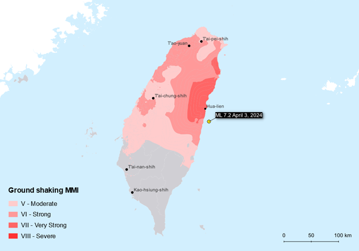
Source: US Geological Survey, Graphics: Guy Carpenter
For 5 days after the initial shock, CWA recorded 740 aftershocks as of the morning of April 8, the largest of these being a magnitude 6.5, approximately 13 minutes after the mainshock. There were shocks with magnitude > 5 daily. Most of the aftershocks occurred north of the initial shock. Because this event ruptured an offshore-extending reverse fault, a tsunami warning was issued for the region. Reports from tide gauges indicate that tsunami heights in Taiwan may have reached 1-2 meters, and approximately 31 centimeters on the Japanese island of Ishigaki, located 200 km away from the epicenter.
Seismotectonic Context
As shown in Figure 3, Taiwan is situated at the nexus of 2 large subduction zones, representing the boundary between the Eurasian plate and Philippine Sea plate. Deformation from their collision has over time resulted in the formation of the Central Mountain range that runs north-south across the island. There are 2 distinct patterns to the plate deformation, with the Eurasian plate subducting under the Philippine Sea plate to the south of the island, while the opposite occurs to the north and east of the island, where the Philippine Sea plate subducts under the Eurasian plate. At the location where this earthquake occurred, the 2 plates are moving toward each other at a rate of 78 millimeters per year (nearly twice as fast as the movement along the San Andreas fault in California).
Seismicity on the eastern side of the island is dominated by 4 faults shown in Figure 3: the Milun fault (32), Longitudinal Valley fault (33), Central Range structure (34), and Luyeh fault (35). The April 3 earthquake occurred close to the Longitudinal Valley fault, which the national seismic hazard model (TEM 2020) defines as having a slip rate of 11.35 millimeters per year, a characteristic magnitude of M7.52, and recurrence interval of 200 years.
Figure 3: 3D block diagram of tectonics around Taiwan (left) and location of major fault structures in eastern Taiwan (right).
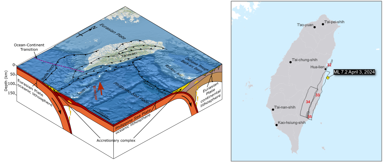
Sources: Wikipedia, Central Weather Administration, Global Earthquake Model, Graphics: Guy Carpenter
The complex tectonics in this region cause the island to be characterized as having high seismic hazard, a designation reinforced by numerous large earthquakes in the historical record. Figure 4 shows that since 1900, there have been 25 earthquakes with magnitude > 7 on or close to Taiwan, equating to 1 every 5 years. Six of these occurred within a 50-km radius of the April 3 earthquake, and a further 8 within a 100-km radius, including the 1999 MW 7.7 Chi-Chi Earthquake.
Figure 4: Earthquakes with magnitude > 7 impacting Taiwan since 1900.
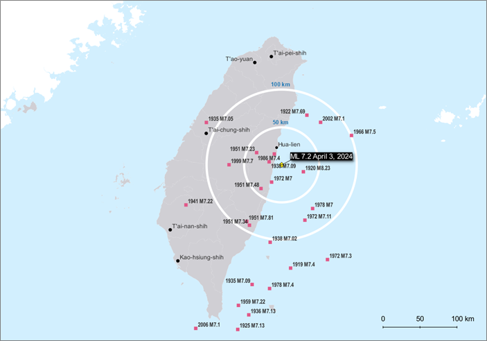
Source: US Geological Survey, Graphics: Guy Carpenter
Damage Impacts
Compared to other major global earthquakes in the last 18 months (e.g., Turkey Mw 7.8, Morocco Mw 6.8, Noto Peninsula Japan Earthquake Mw 7.5), the levels of observed damage and casualties are relatively low from the April 3 earthquake, despite its magnitude. This is partly because the earthquake occurred in a less-densely populated part of the island, more than 100 km away from major cities such as Taipei, Tainan or Kaohsiung. However, the building performance is a testament to the high level of disaster preparedness and resilience practiced in Taiwan.
Taiwan implemented its first seismic design requirements in 1974, based on the US Uniform Building Code. These requirements have undergone frequent updates, including in 1982, 1985, 1989, 1997, 1999, 2005, 2011 and 2022, incorporating learnings from major events such as the 1985 Mexico City and 1999 Chi-Chi Earthquakes. The requirements set out in the design codes are strict and—most importantly—well-enforced. Meanwhile, the government has supported retrofitting schemes for older buildings and has made subsidies available for owners to check the seismic resilience of their buildings. The most recent update in 2022 even included mandates to reinforce illegal or improperly modified constructions using ad-hoc solutions.
As of April 10, there have been 15 fatalities, all are from Hualien County. Only 1 fatality was the result from a collapsed building. There were 1,155 reported injuries, with more than 200 each from Hualien County, Taipei and New Taipei, and over 100 from Taoyuan. As of April 8, 42 buildings were tagged with a red sticker—32 from Hualien County, 2 from Taipei and 4 each from Taoyuan and New Taipei. Yellow stickers were placed on 70 buildings, 35 of which were from Hualien County, 13 from Taipei, 14 from Taoyuan, 7 from New Taipei and 1 from Keelung.[1]
Since Wednesday, April 3, 122,241 households lost water, 372,947 lost electricity and 523 lost natural gas supply. By Saturday, April 6, all recovered water supply and 99% got back their electricity. Repair to natural gas access was 90% completed by April 10. Separately, 80 communication towers were damaged, and repair is scheduled to be completed by April 11.
On April 5, the Education Department reported 515 schools suffered some level of damage. A lab fire in the National Dong Hwa University’s College of Science Technology was estimated to cost TWD 1.92 billion to cover its reconstruction in a new location.[2] Damage to the National Hualien Girls’ High School was estimated at TWD 220 million. In Taipei, 202 schools reported damage, and initial estimates for repairs is around TWD 34 million. However, almost all students returned to their own schools on Monday, April 8, after a 4-day weekend holiday for the Qing Ming Festival (Tomb Sweeping Day).
Hualien County is known for its beautiful scenery, and tourism is an important economic sector. Based on its experience of the 2018 Earthquake, the county government anticipates it will take 2 months for the hospitality industry to return to normal, estimating a loss of TWD 5.3 billion for the month of April.
While Taiwan’s high-tech manufacturing plants are not located in the severely impacted areas, some temporarily stopped production to examine their facilities and equipment, and have been able to resume operation quickly. Assessment of property and business interruption losses is on-going.
The stone industry in Hualien County, which is famous for its high-quality marble, slate and tiles for domestic consumption and overseas exports, suffered an estimated TWD 1 billion in losses. Some businesses are still recovering from the 2018 February 6 6.4 MW Hualien Earthquake.
Taiwan Tobacco and Liquor Corporation suffered damages including almost 200,000 broken bottles of alcohol at its factory warehouse in Hualien, with an estimated loss of TWD 14 million. Its production line will take at least a week to recover. According to the owner, this impact is greater than that from the 2018 earthquake.
Agricultural losses were estimated at TWD 80.96 million, with almost 98% coming in Hualien County. The largest damages affected private and public farming and fishery facilities, with smaller losses to crops and livestock.
It is important to emphasize that not all of the above losses are covered by earthquake insurance.
Comparison with Historical Events
Table 1 compares the April 3 earthquake with recent significant Taiwanese earthquakes as well as the most intense Hualien earthquake since 1900. Please note: information related to the 2024 earthquake is preliminary and expected to change as new observations develop.
Table 1: Comparison of ML7.2 Hualien Earthquake to selected historical events.
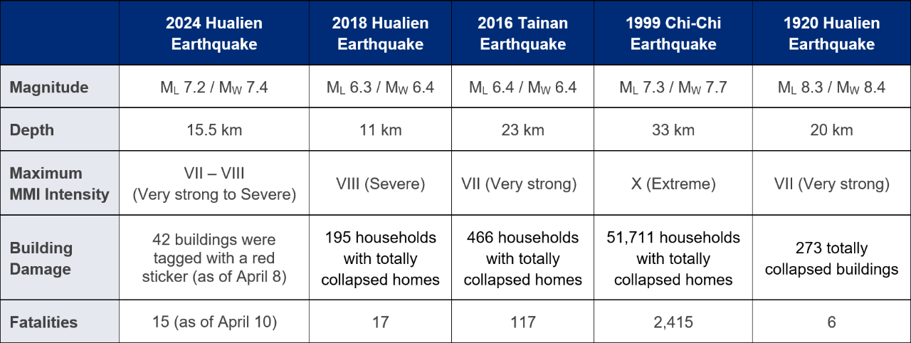
Source: Central Weather Administration, USGS, NOAA
For residential losses, insurance payments come mostly from the Taiwan Residential Earthquake Insurance Fund (TREIF), which the government created after the 1999 Chi-Chi Earthquake. Take-up rates have increased steadily over the last 20-plus years. Hualien County’s take-up rate is about 27%, which is lower than the national average of 37%. Impacted cities in the north—Taipei, New Taipei, Keelung, and Taoyuan—have take-up rates above 40%. TREIF policies pay a maximum of TWD 1.5 million for the building structure and TWD 200,000 for contingent living expenses. On April 8, TREIF reported 472 claims, and estimated TWD 762 million in losses from the recent event. For commercial and industrial risks, earthquake coverage is provided by the private insurance market. The take-up rate is modest for general commercial risks, but higher for high-tech industrial risks.
It is worth noting that TREIF's reinsurance program has been loss-free since its establishment in 2002, and that Taiwan’s catastrophe reinsurance programs have been only moderately impacted—by the 2016 Tainan Earthquake—since 1999. However, the extent of impact from the recent Hualian Earthquake on the local commercial insurance industry is unclear, particularly with regard to losses in the high-tech sector. This is because it typically takes 2 or more weeks for the industry to evaluate and establish reliable loss estimates.
Post Event: Hualien Taiwan Earthquake
Sources: Taiwan Central Weather Administration, US Geological Survey, NOAA, CNA, Taiwan Central Emergency Operation Center, National Land Management Agency, Taiwan Residential Earthquake Insurance Fund, Taiwan Earthquake Model
[1] Red stickers are issued for buildings with key structural damages (columns, beams, exterior walls, floors, foundations, etc.) or building tilting to a certain extent or causing danger. Yellow stickers are issued for buildings with non-major structural damages (interior partitions or ceiling damages), or next to neighboring building(s) that are tilting to a certain extent and causing danger.
[2] 1 USD = 32.013 TWD (Bloomberg, April 10, 4am EDT).