A four-day severe weather outbreak in late April across the Great Plains and Midwest spawned over 120 tornadoes, including at least one 'violent' tornado, a term meteorologists commonly use to refer to tornadoes of at least EF4 strength. The scope and severity of impacts from this outbreak are still being assessed at the time of publication.
Late April Tornado Outbreak
Outbreak Recap
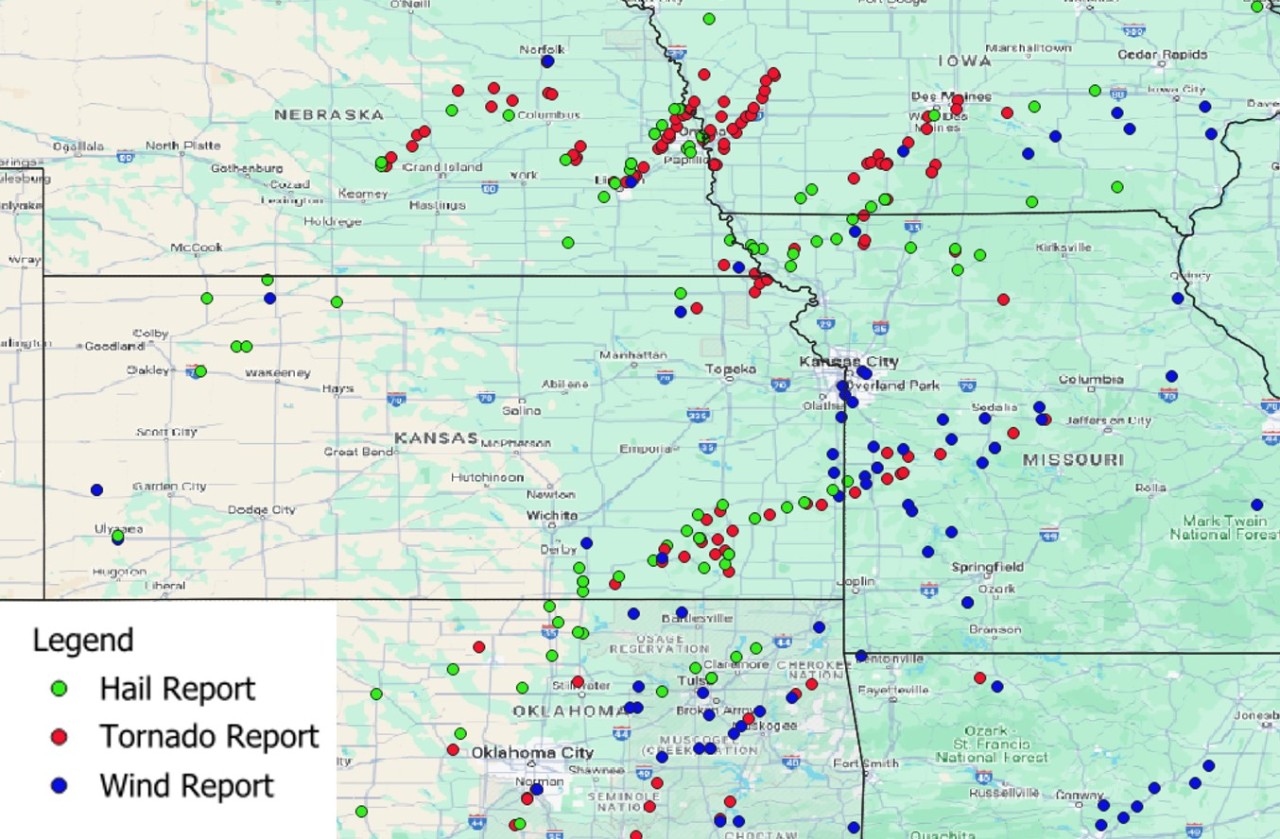
At least 120 tornadoes were generated between April 25 and April 28 across seven different states, according to the National Weather Service (NWS). As damage surveys are ongoing, that number could rise. Multiple EF3 tornadoes have been surveyed, as well as one EF4 that tracked through Marietta, Oklahoma. Official statistics on the outbreak will be published by the NWS once damage surveys are completed.
Meteorological Set-Up
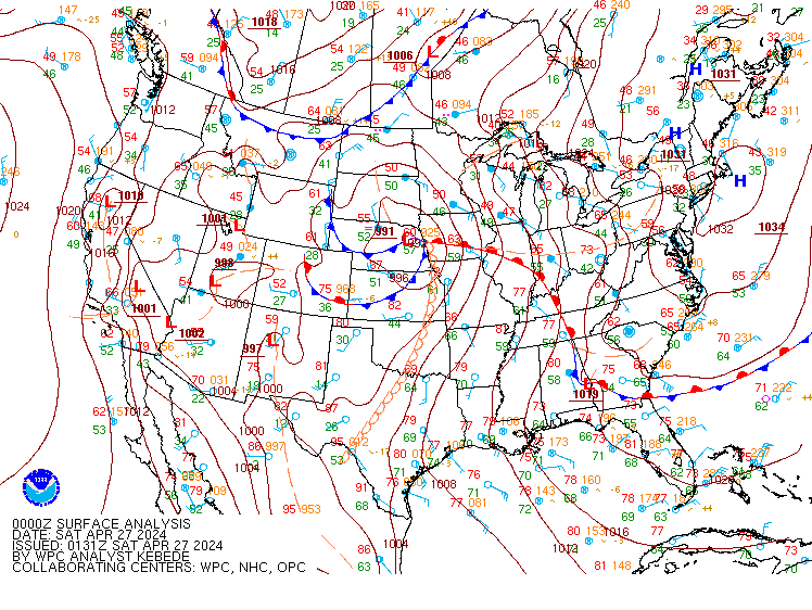
An environment of warm, moist and unstable air and robust wind shear associated with a strong frontal system set the stage for a multi-day outbreak, beginning on April 25. Over the four day period, several clusters of severe thunderstorms were produced. The figure seen below shows a surface analysis from 7 PM on April 26, indicating the strong low pressure system and associated frontal boundaries.
Hail, Wind, and Flooding Damage
In addition to significant tornadic activity, the Storm Prediction Center (SPC) has received over 200 hail reports and over 180 straight-line wind reports as of April 30 over the four day span. Hail over 2 inches in diameter fell in multiple states, including Texas, Oklahoma, Kansas, Nebraska, and Iowa. Damaging straight-line winds, with some gusts in excess of 60 mph, were observed across impacted states. Significant flooding was also experienced across a widespread area.

Observed Impacts
While wind and hail impacts spread from Texas north to the Dakotas and Wisconsin, the most significant damage occurred in the town of Minden, IA where a large tornado touched down, as well as in Elkhorn, NE, where at least 50 homes were significantly damaged by an EF3 tornado (see image below from the NWS office in Omaha). Additionally, an EF3 tornado tossed airplanes in the air at Eppley Airfield (see above).

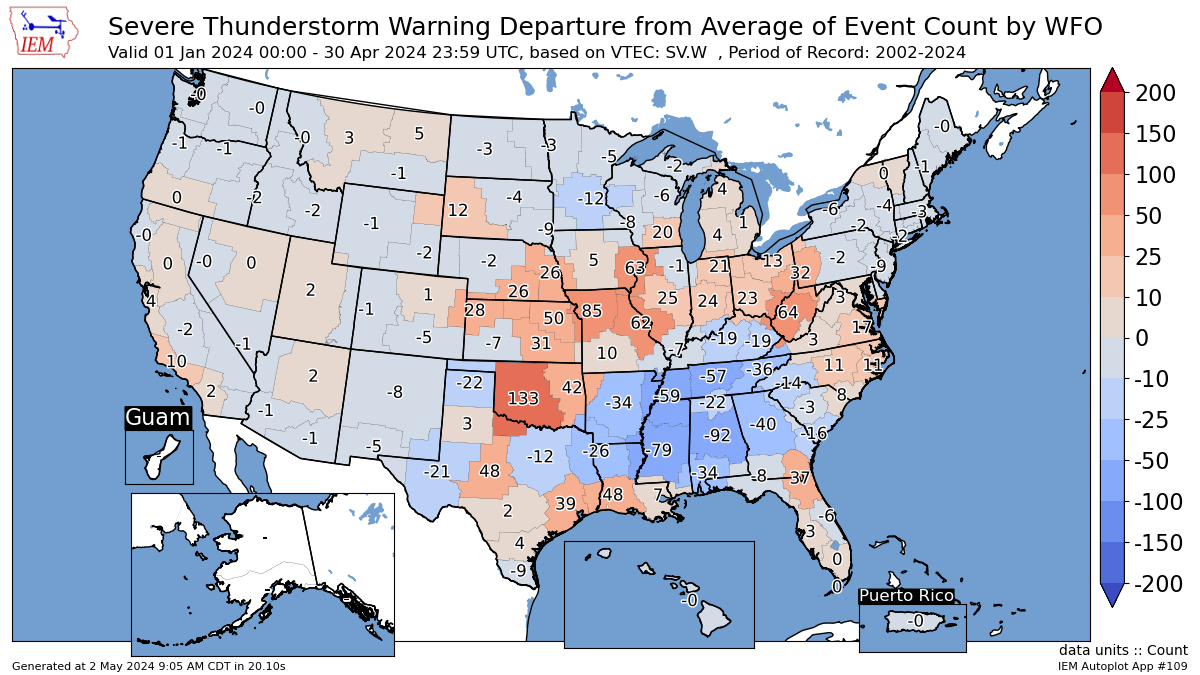
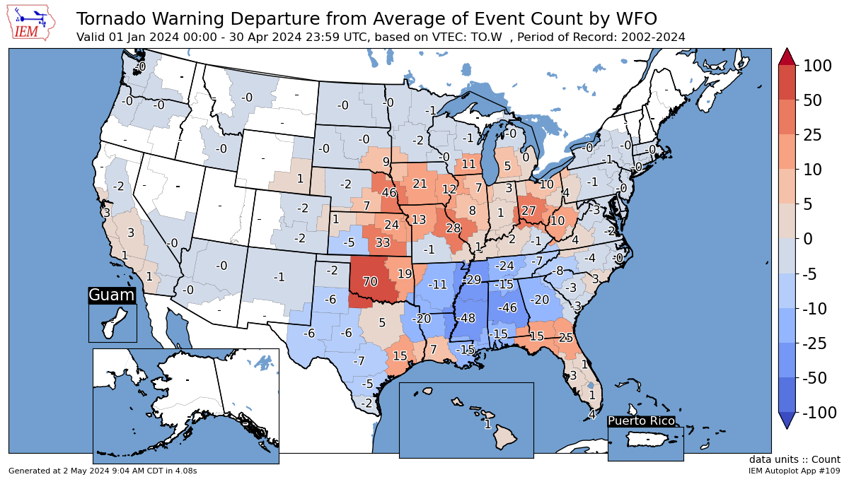
National Weather Service Warning Activity
The maps below show areas of anomalous severe thunderstorm activity (top) and tornado activity (bottom) as measured by the amount of warnings issued by NWS offices compared to an average year. Red shading indicates heightened activity relative to average, including the Midwest, Great Plains and portions of the Eastern Seaboard. In contrast, areas of below average activity have been seen in the Deep South and Upper Midwest.
As of May 1, tornado and straight-line wind activity has been slightly above average, while hail activity has been below average. The Oklahoma EF4 tornado on Friday was the first EF4 in over a year (since March 31, 2023), and the US has not experienced an EF5 Tornado in over 10 years.

How Much SCS Season Is Left?
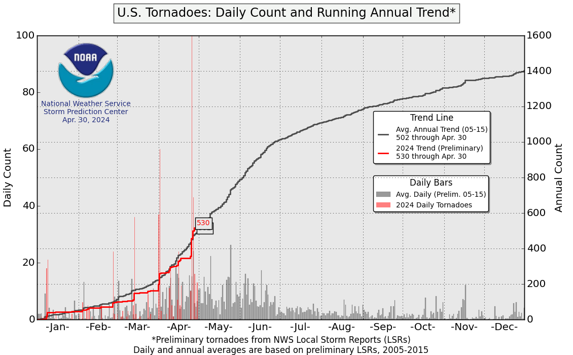
Historically, tornado activity peaks in the late spring and early summer, then tapers off by fall. This season has had an average number of storm reports by May 1, at which point the US is about 35% of the way through tornado season. However, noticeably there has been more volatility than normal, with low activity overall, punctuated by several days of heightened activity, including April 25 to 28 and more recently, April 30.
Severe Weather Outlook
Ramping Up of the Severe Storm Season
Climatologically, spring is the start of severe thunderstorm season in the Central Plains. As larger scale weather patterns shift, May sees the risk of severe thunderstorm activity move northward and into the Midwest, eastern Tennessee, and western North Carolina. Severe thunderstorm risk for the Central Plains typically peaks in June.
What to Expect in May?
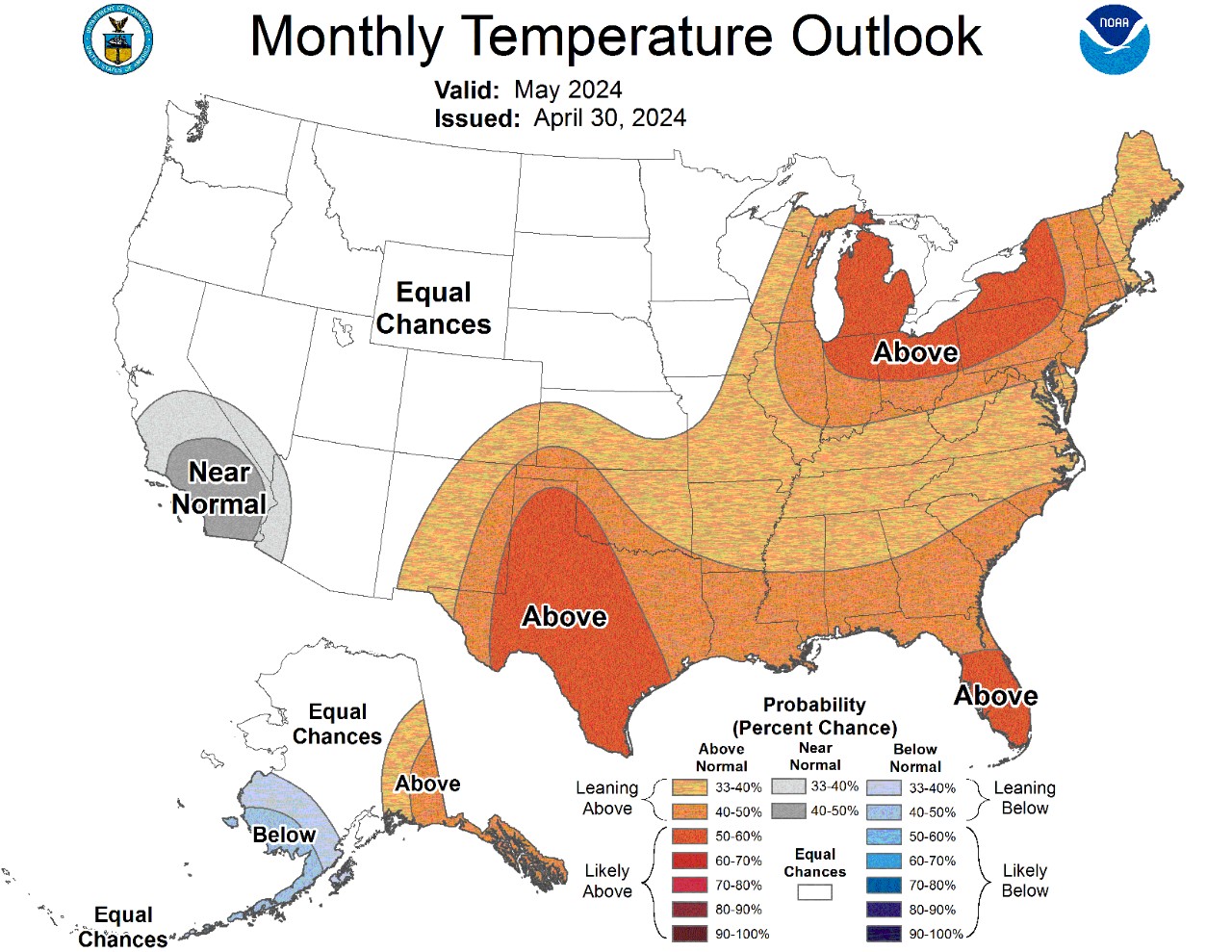
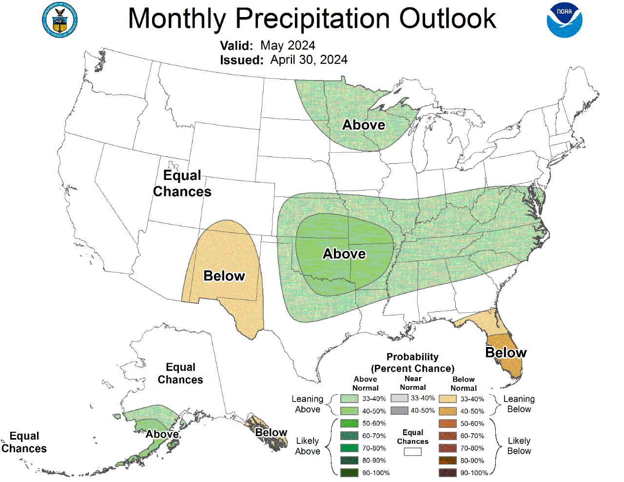
NOAA’s Climate Prediction Center has indicated above average temperatures in the south Central Plains and throughout the southeast and eastern US through May (top image below). This is alongside above-normal precipitation in the south Central Plains extending east (bottom image below), an area that is historically active for severe weather.
Factoring in temperature and precipitation forecasts alongside large-scale weather patterns typical of mid to late spring, conditions will be favorable for severe thunderstorms generally through the month of May.