

Tropical Storm Helene : Northern Gulf Threat
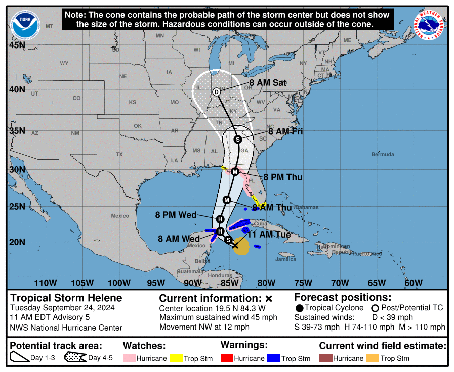
- Current Status: Potential Tropical Cyclone 9 was recently upgraded to Tropical Storm Status after consolidated circulation found by Hurricane Hunter aircraft and analysis by the National Hurricane Center (NHC). The feature is producing maximum sustained winds of 45 mph.
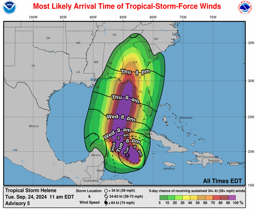
- Forecast Reasoning: Tropical Storm Helene is expected to make landfall somewhere in the Florida Big Bend region sometime late Thursday as a major hurricane per the NHC, with onset of conditions as early as Thursday morning. Factors in play include a ridge to the east and a frontal system over the Central Mississippi Valley. The exact timing and interaction of these features still carries some uncertainty, but model guidance is in reasonable agreement for the overall scenario. As the storm approaches the coast, an increase in forward speed is expected by the NHC which should shorten the duration of impacts (especially rainfall). Following landfall, the storm should weaken and move into the Ohio Valley into the weekend.
- Rapid Intensification Likely: The feature is expected to undergo a period of rapid intensification to reach major hurricane status. Factors in play include exceptionally warm waters at depth, lessening wind shear, and possible ventilation of the storm by the frontal system to the north. The feature should approach the Florida coast Thursday as a major hurricane per the NHC.
- Expected Impacts: This will be a large storm with impacts extending well away from the center of circulation to affect most of Florida and portions of adjacent states. Impacts will be most severe along and to the right of the center of circulation. Major hurricane wind conditions will cause substantial damage to property and infrastructure near and to the right of the center of circulation. Impacts of lesser severity will extend well away from the track to cause light to moderate property damage along with downed trees and powerlines with power outages. A storm surge of 10-15 feet is expected over a substantial portion of the Florida Big Bend Region, with lesser amounts over a much larger area. Severe damage to property and infrastructure is expected due to seawater inundation for coastal areas and adjacent waterways, with more severe damage along the immediate coast due to wave battering. Heavy rainfall is also expected to produce inland flooding, although a faster forward motion may offset these effects. For portions of the Yucatan Peninsula and Grand Cayman, tropical storm and possibly hurricane conditions can be expected over the coming 24-36 hours. Hurricane, storm surge and tropical storm watches/warnings are now active for areas under potential/imminent threat per the NHC.
Tropical Storm John : Mexico Pacific Coast Landfall
- Landfall Status: According to advisories of the National Hurricane Center (NHC), Hurricane John made landfall in Mexico near the border of Oaxaca and Guerrero states early Tuesday Morning. The storm made landfall as a category 3 hurricane with maximum sustained winds of 120 mph. John has since weakened to Tropical Storm status while over land.
- Rapid Intensification: John saw maximum sustained winds increase by 75 knots (85 mph) in the 24 hours leading up to landfall. This was an impressive display of unexpected rapid intensification reminiscent to Hurricane Otis (2023). Fortunately, the inner core of John was very compact and missed the largest population centers on the Mexico Pacific Coast, unlike Hurricane Otis last year.
- Current Status: John remains in a region of weak steering currents and is expected to meander on or near the Mexican Pacific coast before dissipating on Friday. While the storm is not expected to re-intensify if it does re-emerge over the ocean, this erratic movement will prolong heavy rainfall over the region and amplify the flood threat.
- Heavy Rainfall Threat: Rainfall totals in excess of 30 inches are possible along coastal regions of Oaxaca and Guerrero through Friday. The mountainous topography of the region will escalate flash flooding and mudslide threats across the region.


Additional links of interest:
US National Hurricane Center
US National Weather Service