
- The 2025 North Atlantic hurricane season is expected to be active, with total named storms forecasted to be well above average for the 1950-2023 period, and above average compared to the elevated hurricane activity seen between 1995-2023.
- Contributing factors include above average sea surface temperatures in the Gulf of Mexico (locally called Gulf of America) and ENSO-neutral to possible La Niña conditions which favor hurricane development.
- While these predictions do indicate an active season, individual weather patterns during a storm’s lifecycle are more impactful to the likelihood of a hurricane landfall. Seasonal landfall predictions remain a challenge, as forecasts rapidly lose accuracy beyond a 7-to-10-day lead time.
- Property (re)insurers should remain prepared for potential impactful landfalls, regardless of seasonal expectations. Previous seasons with above-average hurricanes have seen a wide range of insured losses, ranging from under USD 1 billion to over USD 100 billion.
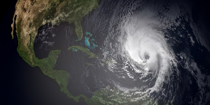
2025 NORTH ATLANTIC HURRICANE OUTLOOK
Above Average Expectations for Hurricane Season
Seasonal outlooks for the 2025 North Atlantic Hurricane season are shown in the table below, from:
- Colorado State University (CSU)
- The Weather Company (TWC)
- Tropical Storm Risk (TSR)
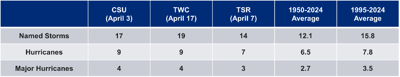
The 1950-2023 average represents a longer-term period where hurricane detection in the Atlantic Basin includes overflight data and then satellite data from about 1970 onward. The 1995-2023 average reflects the current active period of Atlantic hurricane activity that began around 1995.
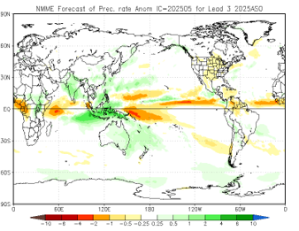
Sea-Surface Temperatures in the North Atlantic
Entering the 2025 hurricane season, sea-surface temperatures (SSTs) remain generally warm across the basin. The Gulf of Mexico (locally called the Gulf of America) and the Caribbean Sea have above average SSTs, but the eastern portion of the Main Development Region (water between Africa and the Caribbean) is running slightly below normal. Despite the presence of cooler waters in the eastern Main Development Region (MDR), SST anomalies more than 1.5°C above normal are found in the western half of the MDR.
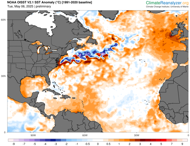
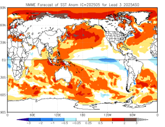
Compared to 2024, sea-surface temperatures are substantially lower, but as of May 18, the North Atlantic is still the third warmest on record. SST forecasts for the August-October core of hurricane season are slightly above average for the MDR and Gulf of Mexico, and average across the Caribbean.
Possible Transition to La Niña During the Second Half of Hurricane Season
The present El Niño Southern Oscillation (ENSO) state falls into ENSO-neutral, with waters around the equator at near-average temperatures across most of the Pacific. The National Oceanographic and Atmospheric Administration (NOAA) forecasts this current state to persist between June and August. Between August and October, the peak of hurricane season, NOAA forecasts a ~50% chance for ENSO-neutral conditions to continue and a ~30% chance for La Niña conditions to develop. The La Niña ENSO state is associated with elevated hurricane and tropical cyclone activity in the Atlantic Basin, and a transition could see an uptick in activity later in the hurricane season. The suppressing effects of El Niño are not expected for this hurricane season.
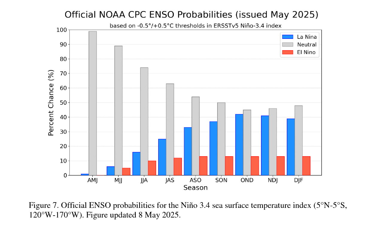
Current models favor ENSO-neutral conditions to persist through the Northern Hemisphere fall and winter. However, there is a large amount of uncertainty at the longer forecast windows, especially going into peak hurricane season months. This makes the number of named storms more difficult to predict at this time of year.
Analog Seasons
Analog seasons that most closely match expectations for 2025 include 1996, 1999, 2006, 2008, 2011 and 2017, according to the seasonal outlook from Dr. Phil Klotzbach of Colorado State University. These seasons produced a range of activity, seeing between 10-17 named storms, 5-10 hurricanes, and 2-6 major hurricanes. Of note, 2017 produced 10 hurricanes; of the 3 that made landfall, 2 reached Category 4 (Harvey and Irma). In contrast, 2006 saw none of its five total hurricanes make landfall.
Insured Losses
Insured losses are determined by several different factors, including hurricane landfalls in a given season, affected population centers, construction characteristics, portfolio makeup and policy terms. Insured losses for any given season range from marginal to over USD 100 billion.
While basin activity can indicate directionality of insured losses for a season, it is not a reliable predictor of insured loss due to wide variability from season to season. The Atlantic basin has seen a seasonal range of 2-15 hurricanes between 1950-2024, with a landfall to basin ratio between 0%-86% (average between 20%-25%). This is because hurricane landfalls in a year are largely driven by daily weather conditions, not by larger climate patterns.
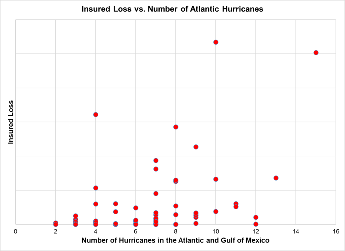
Recent years have seen an uptick in rapid intensification events near the coast, where a hurricane sees an increase in maximum speed of at least 30 knots (35 mph) in a 24-hour period. Rapid intensification events are more challenging to forecast, and their quick development reduces warning times, preparation and evacuation periods for affected communities. Given the Atlantic is seeing warmer-than-average coastal temperatures, this will be an item to watch for the season.
Overall, the expected number of hurricanes in a season is not a reliable predictor of insured losses. (Re)insurers should remain prepared for impactful landfalls in any season, given the inherent uncertainty of hurricane landfall rates and the potential for storms to rapidly intensify as they approach the coast.