The Tropics Awake
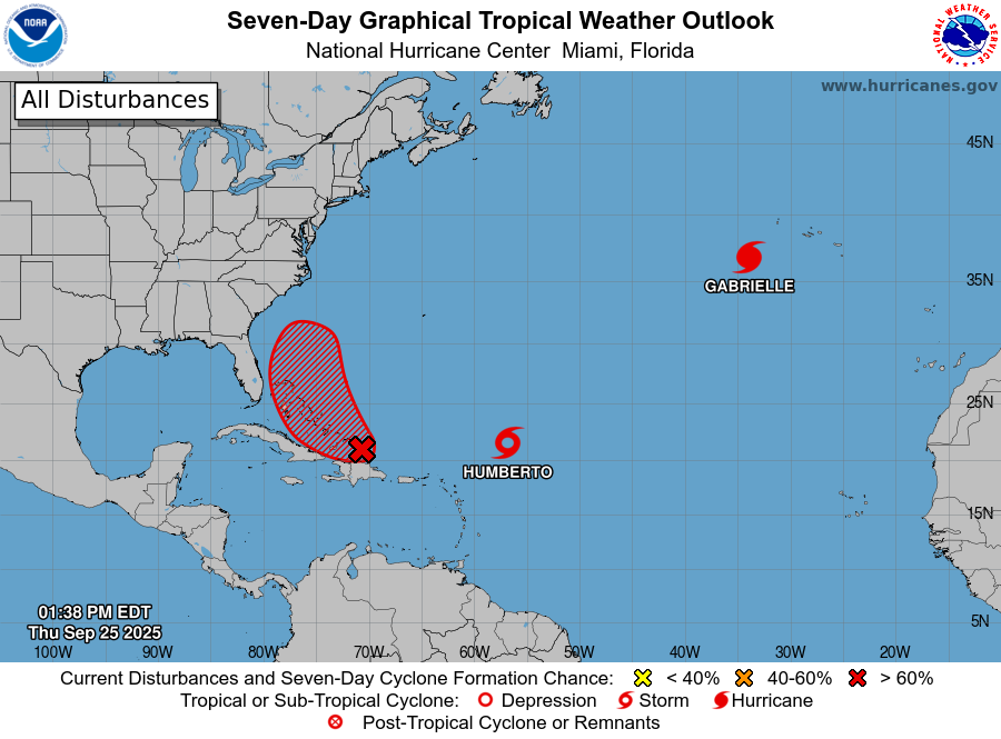
In the Atlantic Basin, the National Hurricane Center (NHC) is monitoring 3 areas of interest. The feature most concerning for property (re)insurance interests is a Caribbean disturbance that could affect the Carolinas as a tropical storm or even a hurricane early next week. Meanwhile in the Tropical Pacific, Super Typhoon Ragasa recently affected portions of Taiwan and Mainland China with impacts from severe flooding and damaging winds.
Live Report: In creasing Storm Activity in the Tropics
Caribbean Disturbance – Potential US Southeast Landfall
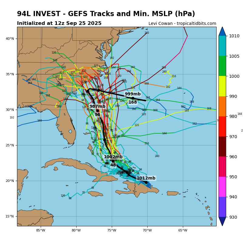
- A tropical disturbance is producing showers, thunderstorms and gusty winds over portions of Hispaniola and the Turks and Caicos Islands, according to the National Hurricane Center (NHC).
- Over the coming days, this feature should move toward the Bahamas, passing over very warm waters, in a moist environment with reduced wind shear. Accounting for these factors, the NHC is expecting an 80% chance that the feature will develop into a tropical cyclone over the next couple of days. Model guidance indicates probable development into a tropical storm, with possible development into a hurricane within 72 hours. Once the system develops a closed circulation the situation should begin to clarify.
- The forecast track of what should be named “Imelda” could make landfall in the Carolinas within 5 days, perhaps as early as Monday evening. Another possibility is that Imelda could recurve back into the Atlantic. The factors in play include a frontal system to the west as it clears the mainland, and Tropical Storm Humberto to the east. If Humberto gets close enough it could cause Imelda to pivot further to the east (called the “Fujiwara Effect” – where the circulation of two storms cause their paths to pivot around each other). The timing and interaction of the disturbance with these 2 features over the coming days will determine the ultimate track of the storm. Current model guidance indicates the Carolinas landfall is more probable. However, several runs of a single model with slightly varied initial conditions (known as an ensemble) show a great deal of spread in scenarios.
- As the situation evolves over the coming days some clarity should develop on both the forecast track and intensity.
Tropical Storm Humberto
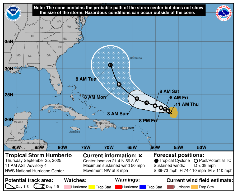
- In the central Atlantic, Tropical Storm Humberto has maximum sustained winds of 50 mph with a northwest motion of 8 mph.
- Humberto is expected by the NHC to move between the U.S. Mainland and Bermuda through mid-week, while strengthening into a major hurricane in the meantime. The track and intensity of Humberto will be a critical factor for the other Caribbean disturbance likely to be named Imelda.
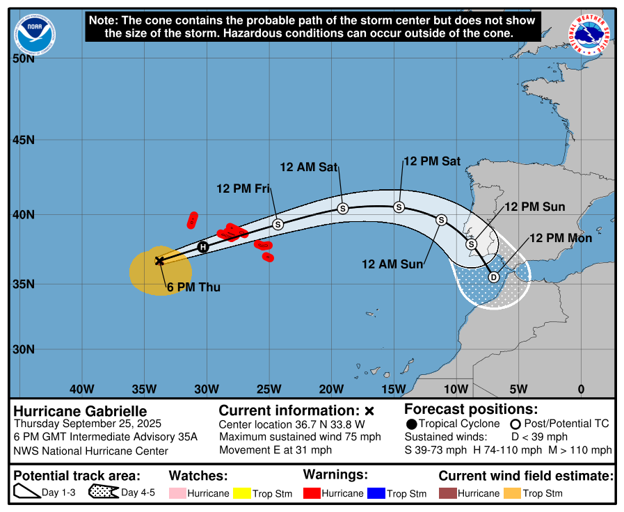
Hurricane Gabrielle
- In the eastern Atlantic, Hurricane Gabrielle is moving eastward at 31 mph as a minimal category-1 hurricane. Hurricane conditions are an active threat for the Azores where hurricane warnings are in place.
- Gabrielle is expected by the NHC to begin extratropical transition (into a frontal system) while weakening to tropical storm strength as it approaches the coast of Portugal this weekend, where gusty winds and heavy rainfall are expected.
West Pacific - Super Typhoon Ragasa
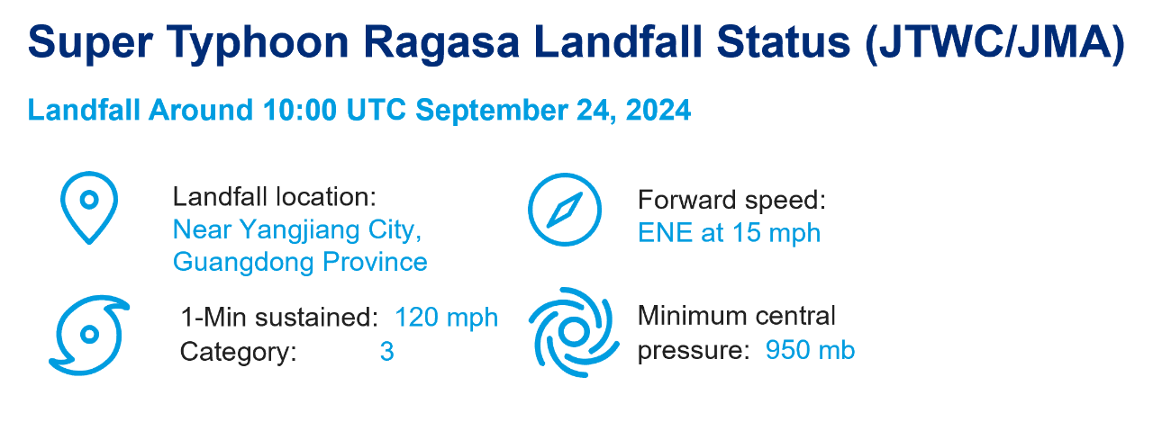
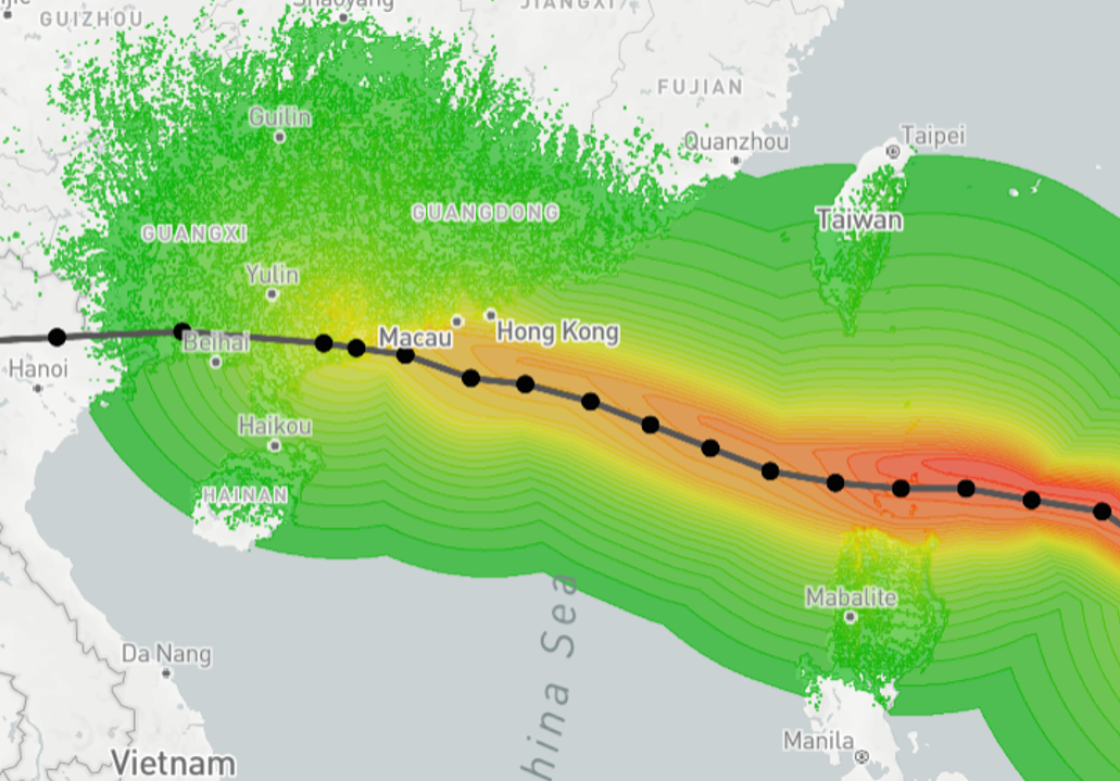
- In the southern province of Guangdong of Mainland China, Ragasa made landfall Wednesday around 17:00 local time (10:00 UTC) near Yangjiang City.
- Just prior to landfall at 06:00 UTC September 24, the Typhoon had 1-minute sustained winds of roughly 120 mph (193 km/hr), equivalent to a category-3 on the Saffir-Simpson Scale according to the Joint Typhoon Warning Center (JTWC). Minimum central pressure was reported at 950 mb per the Japan Meteorological Agency.
- Several coastal cities in the area were affected from hurricane winds and severe coastal flooding, with interior flooding due to excessive rainfall. At least 90 people were injured in Hong Kong, and evacuations affected at least two million in these affected areas.
- In Taiwan, at least 14 fatalities have been reported after severe flooding in the east, following the burst of a barrier lake in Hualien County Tuesday. At least 33 remain missing with 32 injured per media reports. Ragasa passed south of Taiwan but still brought strong winds and excessive rainfall, with flood impacts in mountainous areas.
- Ragasa also rendered severe impacts to portions of the Philippines, where the storm made landfall at peak intensity on the Panuitan Island in northern Cagayan province. At least ten fatalities were reported in the Philippines.
- The remnants of Ragasa continue to bring the threat of gusty winds and heavy rainfall with flooding to portions of Vietnam and Laos Thursday.
- Super Typhoon Ragasa is so far the world’s most powerful storm this year, reaching status as an equivalent category-5 on the Saffir-Simpson Scale with maximum sustained winds of roughly 165 mph (265 km/hr).