
October 28, 2025
Key Headlines
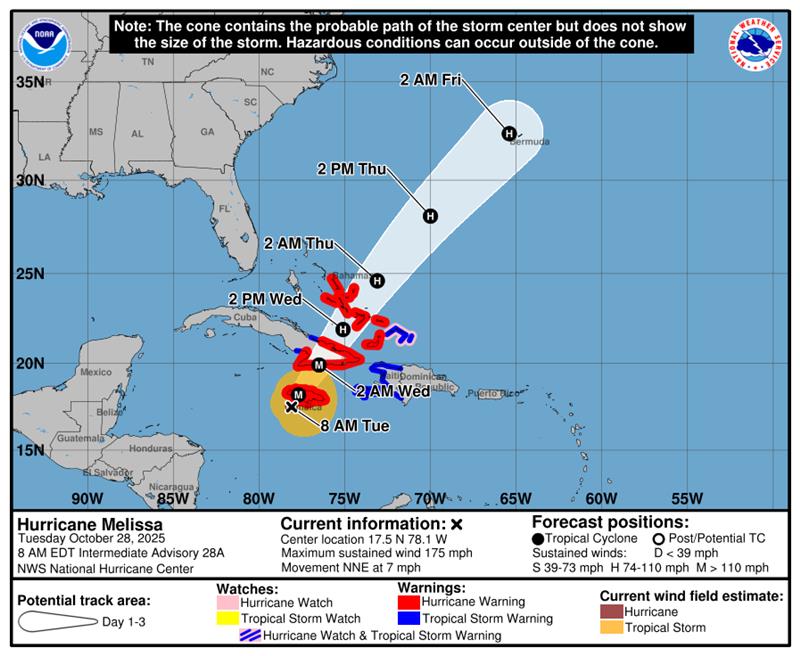
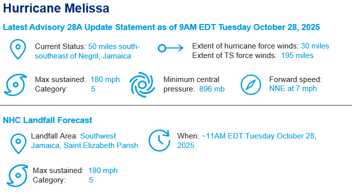
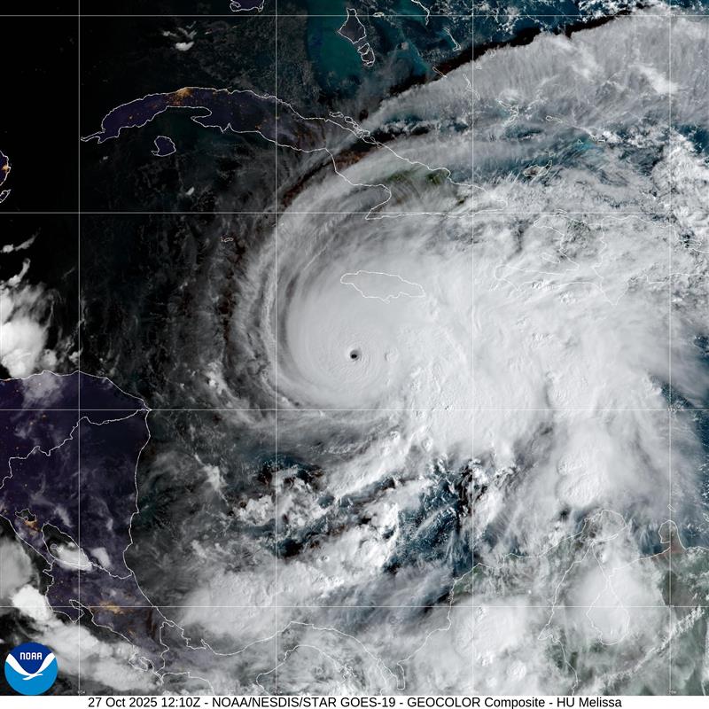
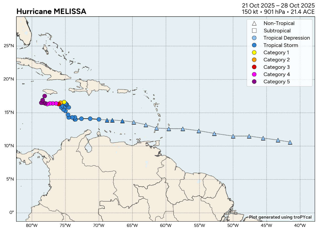
- Current Conditions: At 9 AM EDT, the National Hurricane Center has listed Melissa as a 180-mph category 5 hurricane 50 miles south-southeast of Negril, Jamaica. The current estimated motion is north-northeast at 7 mph. Melissa is moving faster this morning after turning to the north overnight. An additional pivot toward the northeast with an increase in forward speed is expected later today, followed by a faster northeastward motion on Wednesday and Thursday. Hurricane warnings are in effect for Jamaica, southeastern and central Bahamas, and Cuban provinces of Granma, Santiago de Cuba, Guantanamo, and Holguin. Hurricane watches are in effect for Turks and Caicos Islands. Tropical Storm warnings are in effect for Haiti, Turks and Caicos Islands and the Cuban province of Las Tunas.
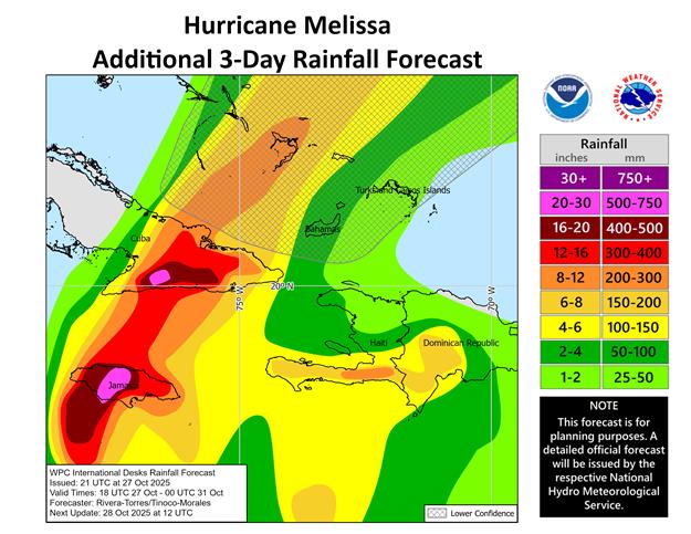
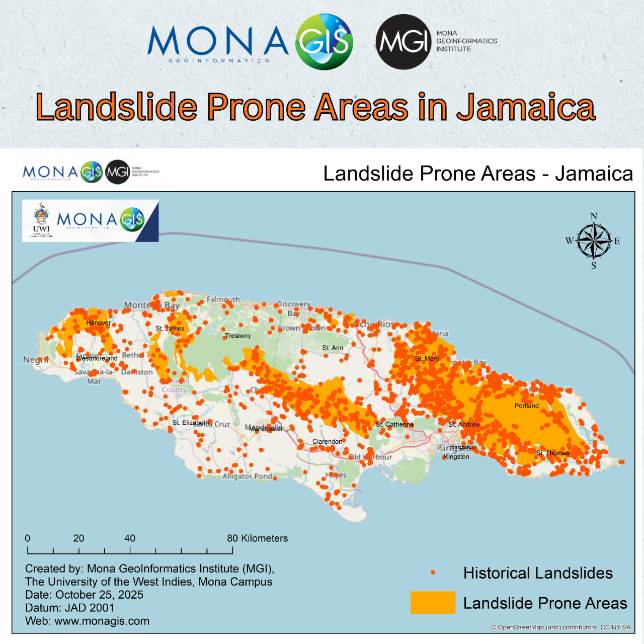
- Jamaica and Cuba Impacts: Melissa is expected to make landfall in Jamaica during the next couple hours and move across southeastern Cuba Wednesday morning. Melissa is forecasted to maintain its category 5 intensity as it makes landfall in Saint Elizabeth Parish, Jamaica. Peak storm surge heights could reach 9 to 13 feet above ground level, near and to the east of where the center of Melissa makes landfall. This storm surge will be accompanied by large and destructive waves. On the northwest coast of Jamaica, near Montego Bay, there is the possibility of 2 to 4 feet of storm surge above ground level. Melissa is expected to bring rainfall of 15 to 30 inches to portions of Jamaica with storm total local maxima of 40 inches possible. Catastrophic flash flooding and numerous landslides are likely. Melissa is expected to weaken post Jamaica landfall, but the track is largely missing the large Jamaican mountains. As a result, the Cuba landfall intensity is expected to still be category 3 or 4 strength. In eastern Cuba, storm total rainfall of 10 to 20 inches, with local amounts to 25 inches, is expected into Wednesday, resulting in life-threatening and potentially catastrophic flash flooding with numerous landslides. There is a potential for significant storm surge along the southeast coast of Cuba late today or Wednesday. Peak storm surge heights could reach 7 to 11 feet above normal tide levels, near and to the east of where the center of Melissa makes landfall.
- Bahamas and Turks and Caicos Impacts: After an eastern Cuba landfall, Melissa is forecasted to move across the southeastern and central Bahamas, as well as the Turks and Caicos on Wednesday. Sustained wind speeds are expected to be near 100 mph even after the Cuba and Jamaica landfalls, therefore significant wind impacts are possible for these islands. Total rainfall of 5 to 10 inches is expected to result in areas of flash flooding. Storm surge of 4 to 6 feet above normally dry ground is possible in the southeastern Bahamas and Turks and Caicos Islands on Wednesday.
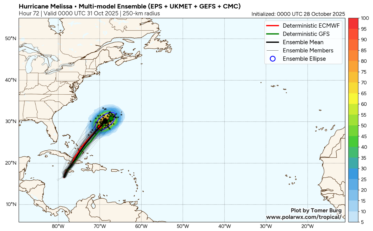
- Potential Bermuda Impacts: Late Thursday into early Friday, there is potential for Melissa to make landfall in Bermuda as a category 1 or 2 hurricane. Watches could be required later today or tonight. Later this evening, uncertainty for the Bermuda track and intensity forecast will reduce significantly after the storm makes landfall in Cuba and Jamaica.
- A Historic Storm: Melissa is set to be the Atlantic Basin’s first Category 5 landfall since Hurricane Dorian (2019) and the first category 5 storm to make landfall in Jamaica. According to the Weather Channel, the 896 mb central pressure reading this morning would list Melissa as the 6th strongest hurricane on record and maintaining this pressure at landfall would result in the 2nd strongest landfall on record for the basin (based on sea level pressure). Expected impacts include severe to complete structural failure near and adjacent to the core of the storm. Catastrophic impacts to infrastructure including power, communications, water and transportation are also probable. In coastal areas, severe to complete destruction of property and infrastructure is probable near and to the right of the core of the storm due to seawater inundation from storm surge and wave battering. Excessive rainfall will also produce extensive freshwater flooding and mudslides, especially in areas of complex terrain. Wind gusts in mountainous areas are projected to be well over 200 mph. Saint James Parish in northwest Jamaica is the fourth most populous parish on the island (nearly 200,000 people) and contains Montego Bay, the fourth most populous urban area on the island. Montego Bay is a popular tourist destination featuring several resorts and is forecasted to be impacted by the eyewall of Melissa.
Additional links of interest