

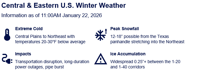
Severe Cold and Winter Weather to Impact Central and Eastern US
Key Headlines
• Severe Winter Conditions Forecast: Winter weather impacts are expected for much of the central and eastern US through the weekend.
• Snow, Ice, and Freezing Temperatures: Expected hazards include freezing rain, heavy snow and extreme cold, with a frontal boundary and developing low pressure to the south and exceptionally cold air to the north.
• Significant Impacts Anticipated: A variety of impacts to affected areas is expected, including severe transportation disruption, property damage due to pipe fracture and downed tree limbs, and power outages. Impacts should affect a very broad area, with greater severity in southern states and the Appalachians.
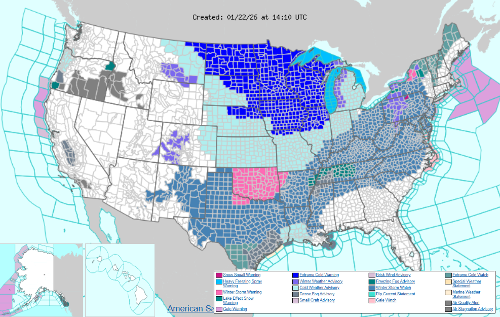 Watches, warnings, and advisories in place as of 8:10 a.m. EST on January 22, 2026.
Source: NWS.
Forecast Winter Weather Hazards
An intense cold snap across the eastern two-thirds of the United States will set the stage for an impactful winter storm this weekend through Monday. Arctic air and sub-zero temperatures will be present across the upper Midwest and Northeast on Friday and Saturday, stressing vulnerable populations and infrastructure ahead of the incoming storm.
An influx of subtropical moisture into the Southwest US on Friday will clash against the entrenched cold air and lead to the development of a low-pressure system over Texas that will begin to move east-northeast. A large region of winter precipitation will blossom along the boundary of the arctic air and warmer subtropical moisture located across the Southeast US on Saturday.
Saturday will bring heavy snow to regions north of the temperature boundary, with Kansas, northern Oklahoma, northern Arkansas, southern Missouri, and the western Ohio River Valley currently forecasted to have the highest totals. South of the band of snow, warm subtropical air is expected to advance northward while being undercut by stubborn low-level cold, leading to freezing rain and dangerous ice storm impacts. Central Texas, northern Louisiana, central and southern Arkansas, northern Mississippi, and northern Alabama appear to be the focus of potential ice accumulations on Saturday.
The snow and ice threat will move northeastward through Sunday, with heavy snow overspreading Appalachia, the Mid-Atlantic, and the Northeast, including the I-95 corridor from Washington, D.C., to Boston. There remains some uncertainty regarding how far north impactful precipitation pushes, leading to lower confidence in heavy snowfall over New England, given current forecast guidance. At the same time, the focus of icing will move into Tennessee, northern Georgia, southern Virginia, and the Carolinas on Sunday. Snow is forecast to continue over the Northeast on Monday as the low-pressure system intensifies off the East Coast, however, the icing threat across the Southeast will have diminished by that time.
It is notable that all weather models have shifted the overall storm track northward in recent days, and it is possible that these trends continue with coming forecast cycles. A continuation of this north trend would ease icing impacts across the south, while increasing snowfall totals across the Northeast, most notably in the New York City and Boston Metropolitan areas. Impactful icing would encroach on major Mid-Atlantic metros if these northerly trends continue.
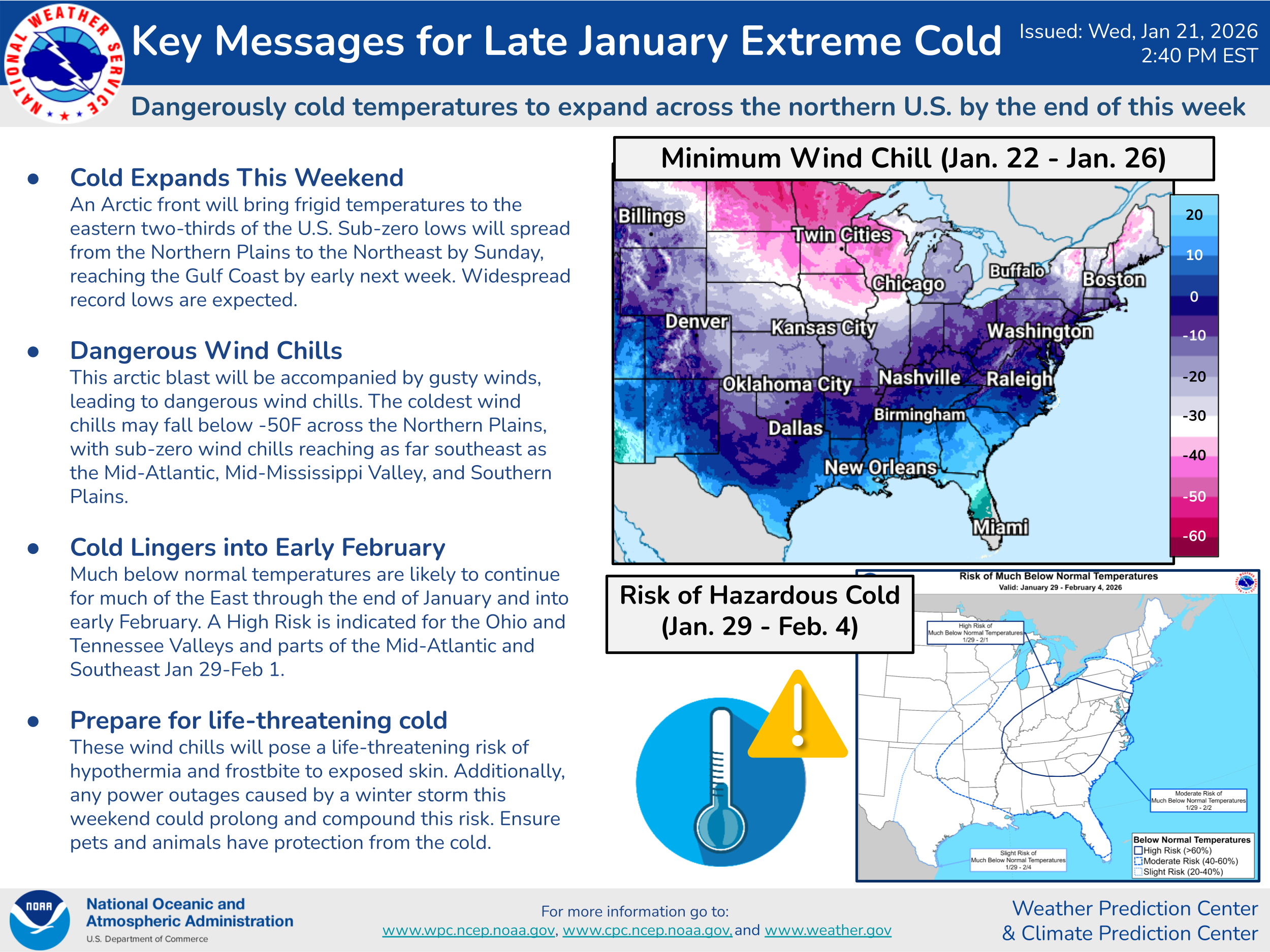 Key messages from the National Weather Service for the upcoming storm system, as of 4:10 a.m. EST, January 22, 2026. Source: WPC.
Expected Impacts
With extreme winter weather conditions expected from New Mexico all the way through New England, current media estimates place 180 million people in the storm’s path. Widespread flight delays and cancellations are expected across the country this weekend, with special concern in the Dallas, Houston, Charlotte, Memphis, Atlanta, Washington D.C., and New York metro areas.
Current forecast models estimate a potentially crippling 12-18 inches of snowfall in localized areas, stretching from the Southern Plains through the lower Great-Lakes, Mid-Atlantic, and Northeast. It is currently difficult to pinpoint exactly where the transition from snow to freezing rain will take place but freezing rain accumulations of 0.25 inches are likely over widespread areas between the I-20 and I-40 corridors, with some localized areas seeing accumulations exceeding 0.5 inches. Areas impacted by excessive ice accumulation could lead to long-duration power outages, extensive tree damage, and dangerous travel conditions.
In addition to the severe winter precipitation, a dangerously cold air mass behind and north of this system will see temperatures 20-30 degrees below average, stretching as far south as Dallas-Fort Worth in Texas. Wind chills are expected to drop to -50°F in some portions of the Upper Midwest and Northern Plains, and the southern plains and southeast could see below-freezing daytime temperatures persist until early next week. Widespread extreme cold conditions pose a high risk of frozen and burst water pipes, frostbite, and hypothermia. The duration of this event is also notable, as persistent sub-freezing temperatures will stress even properly winterized infrastructure systems.
Key messages from the National Weather Service regarding the forecast extreme cold, as of 2:40 p.m. EST, January 21, 2026. Source: WPC.
Notable Winter Weather in the Last 5 Years
Recent US winter storm experience shows that the most consequential losses are driven less by snowfall or wind and more by extreme cold interacting with infrastructure and exposure vulnerability.
The clearest example is the prolonged Arctic cold outbreak from February 2021 (unofficially named “Uri” by the Weather Channel). Exceptionally cold air impacted Texas and the south-central US—regions with building stock and infrastructure not designed for sustained freezing temperatures.
Prolonged power outages led to widespread loss of heat, resulting in extensive pipe-burst and water damage across residential, commercial, and multifamily properties. Economic losses from this winter system are widely estimated in the USD 80-130 billion range, placing it among the costliest natural disasters in US history, while trended insured losses have an estimated range of USD 12-15 billion, reflecting both the severity of property damage and significant business interruption. Critically, this outbreak demonstrated how infrastructure failure acts as a loss multiplier, transforming a cold-weather event into a systemic industry loss.
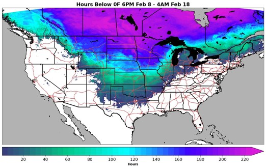 February 2021 cold air outbreak, showing the number of hours below 0°F. Source: Weather Prediction Center (WPC).
A second, more recent analogue is the widespread freeze event from late December 2022 (unofficially named “Elliott” by the Weather Channel), which struck much of the central, eastern, and southeastern United States in late December 2022. Unlike Uri, Elliott did not hinge on a single grid collapse but instead produced a continental-scale freeze affecting more than 40 states simultaneously.
Trended insured losses from this system have an estimated range of USD 8-10 billion, with total economic losses commonly cited in the USD 10+ billion range. As with Uri, the dominant insurance loss drivers were freeze-related water damage, supplemented by elevated auto losses and localized power outages tied to cold-weather generation and natural-gas supply constraints. Elliott reinforces that winter storm risk is not confined to traditionally warm regions; even markets accustomed to cold weather can experience material losses when temperatures drop rapidly and remain below design thresholds.
Taken together, these events offer clear lessons for evaluating winter storm loss severity potential. First, duration matters: the longer freezing temperatures persist, the greater the probability of pipe failures and outage-driven loss amplification. Second, post-Uri improvements have reduced (but not eliminated) risk, particularly through enhanced grid and fuel-supply winterization in Texas, and broader cold-weather reliability efforts following Elliott. Finally, winter weather impacts to insured exposures can be non-catastrophic in appearance but catastrophic in aggregation for a portfolio. A more common example includes high-frequency, moderate-severity water damage claims that can accumulate rapidly across large geographies. These lessons suggest that while the probability may be lower today for infrastructure failure such as we saw with previous storms, freeze-driven property losses remain a material and repeatable winter peril across much of the United States.
Guy Carpenter’s North America Peril Advisory will continue to monitor the impacts of this winter system over the coming days. Please visit your local NWS office webpage for the most up-to-date information. Please note this system has been unofficially named “Fern” by the Weather Channel and may be referred to as so throughout the media.