
Summary
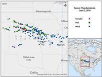
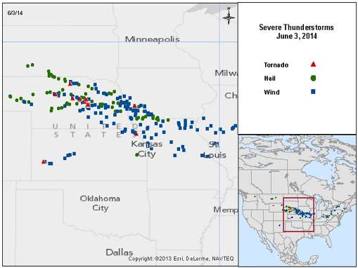
A severe weather outbreak led to excessive wind gusts, significant hail, and a handful of tornadoes on June 3, according to reports. The area most severely affected covers the eastern two thirds of Nebraska together with portions of Iowa, Missouri, Kansas and Illinois.
The extent, length and severity of straight-line (nontornadic) wind reports indicate a probable derecho.

Source: U.S. Storm Prediction Center (NOAA).
Hazard data illustrated in the CAT-i map was taken from i-aXs®, Guy Carpenter’s web-based risk management platform. i-aXs users can view impacted areas on any map as well as see how their portfolios were affected. Please contact your broker or GC Analytics® representative for assistance or go to www.i-axs.info for further information.
Reports of downed trees and power lines, together with light to moderate structural damage, are widespread across the affected area. Severe crop and auto damage have also been reported. Flooding has been reported in Omaha, Nebraska under excessive rainfall. It is far too early to fully establish the scope and severity of this event. The aggregate of light damage over a large affected area could be substantial.
Meteorological Discussion
This severe weather outbreak was enabled along a nearly stationary frontal boundary cutting through the U.S. Midwest. Severe thunderstorms were enabled by the presence of warm, moist air at the surface, cold air at flight level, and wind shear (changing wind speed and direction with height). The air currents associated with this system were especially aggressive, allowing strong downward wind bursts over a sustained period of time in severe thunderstorm clusters.
The extent, length and severity of straight-line (nontornadic) wind reports indicate a probable derecho, consistent with radar signatures in the affected areas during the event.
Straight-line wind gusts exceeding 74 mph were reported in Nebraska in areas including Rock, Washington, Valley, Garden and Gage Counties. Such gusts were also reported in Iowa including Taylor, Cass and Harrison Counties according to the U.S. Storm Prediction Center (SPC). Some wind gusts were reported to exceed 90 mph.
Hail exceeding two inches in diameter was reported in Custer, Antelope, Madison, Stanton, Dodge, Washington, Blaine, Platte, Scott's Bluff, Morrill, Saunders and Saline Counties in Nebraska. In nearby Iowa, two inch or larger hail was reported in Decatur, Taylor, Ringgold and Page Counties according to SPC reports. Isolated hail reports exceeding four inches were found in Washington, Scott's Bluff and Morrill Counties in Nebraska.
Tornadoes of unconfirmed intensity were reported in Rock, Valley, Greeley, Thomas, Howard and Custer Counties in Nebraska. Tornadoes were also reported in Pottawattamie County in Iowa according to the SPC.
Excessive rainfall was also reported with this event, with many locations receiving between two and four inches of rainfall. Omaha, Nebraska reported a daily record of 5.3 inches of rain.
The severe weather threat continues today in the Ohio Valley, although the magnitude of the threat has lessened considerably since yesterday.
Impacts
Reports of downed trees and power lines are widespread, together with light to moderate structural damage as a result of straight-line wind gusts. One truck was reported flipped in Greeley County, Nebraska. A two foot diameter live Maple was reported downed during the storm. There are widespread reports of damage due to downed trees.
Hail caused light to moderate structural damage with considerable crop and auto damage according to SPC reports. In Council Bluffs, Iowa, at least 25 vehicles with hail damage were reported along I-29. At least a dozen injuries were reported as a result of hail.
Omaha, Nebraska was subject to flooding due to excessive rainfall, according to reports. Police had to use boats to rescue stranded motorists in the area.
Primary elections were affected by the storms in Iowa and South Dakota. The Iowa Governor also declared a state of emergency in Pottawattamie County. Reports also indicate that the Eppley Airfield Airport was closed for several hours.
The National Weather Service indicated that the heaviest damage was located near the Nebraska-Kansas border in Nemaha County, where at least one home was destroyed and others were damaged.
It is too early to establish the full scope and magnitude of the impacts of this event, but the aggregate of light to moderate structural damage over a large affected area could be substantial.
Sources: U.S. National Weather Service (NOAA), U.S. Storm Prediction Center (NOAA), Associated Press, Reuters, Agence France Presse.
Guy Carpenter publishes CAT-i reports for major natural catastrophes worldwide. These reports cover catastrophes including worldwide tropical cyclones, earthquakes, major UK and European floods and any other natural event that is likely to incur a significant loss to the (re)insurance industry. Please email mailto:CAT.i@guycarp.com if you wish to be added to the free email distribution list.
Guy Carpenter compiles RISK-i reports for major technological or man-made events worldwide. These reports cover risks to property, transport and life including explosions, fires, crashes, engineering disasters and terrorist attacks that are likely to incur a significant loss to the (re)insurance industry. Please email RISK.i@guycarp.com if you wish to be added to the free email distribution list.