
In the Northwest Pacific Basin, Typhoon Lekima is moving ashore on the coast of Mainland China. Just prior to landfall, one-minute sustained winds were around 175 km/hr (110 mph), equivalent to a Category-2 on the Saffir-Simpson Scale, according to the Joint Typhoon Warning Center (JTWC) at 15 UTC August 9. The storm is weakening due to dry air intrusion and increasing land interaction. The storm is moving to the northwest at about 11 km/hr (7 mph).
Hazards of concern include significant winds to produce downed trees and powerlines along with variable property damage, especially for points along and to the right of the track. A significant storm surge is also expected to produce coastal flooding with damage due to seawater inundation and wave battering. Heavy rainfall is also expected to produce significant flooding and flash-flooding, and the threat will extend well to the north and inland from the point of landfall as the storm moves inland. Watches and warnings have been issued by official agencies.
Passage of Lekima brought rainfall totals of at least 350 mm (14 inches) as reported by media in portions of northern Taiwan. The storm also recently crossed the southern islands of Japan as a super-typhoon, with one-minute sustained winds of about 240 km/hr (150 mph) reported by the JTWC at 12 UTC August 8 (equivalent to a strong Category-4 on the Saffir-Simpson Scale). Wind gusts of at least 167 km/hr (104 mph) were unofficially reported by media for Miyako Airport. Rainfall amounts of 280 mm (11 inches) were reported in Miyakojima.
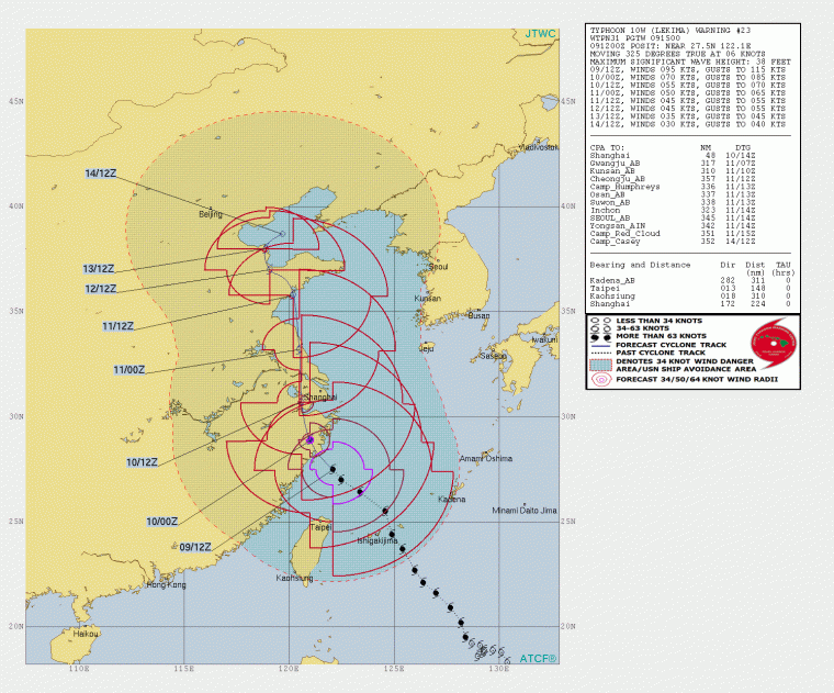
Typhoon Lekima Position and Best Forecast. Source: JTWC.
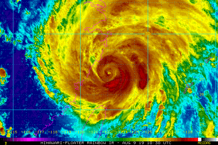
Typhoon Lekima satellite image ending 1730 UTC August 9. Source: NOAA.
Typhoon Krosa
Meanwhile, Typhoon Krosa carries one-minute sustained winds of around 160 km/hr (100 mph) according to the JTWC at 15 UTC today (equivalent to a category-2 on the Saffir-Simpson Scale). The storm is expected by the JTWC to begin moving on a general track to the northwest and may pose a threat for typhoon landfall in Japan next week. Official updates can be found at the Japan Meteorological Agency.
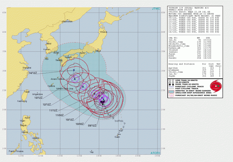
Typhoon Krosa Position and Best Forecast. Source: JTWC.
Typhoon Francisco
Earlier in the week, Typhoon Francisco made landfall in southern Japan after 18 UTC August 5. The storm strengthened to typhoon status just prior to landfall, with one-minute sustained winds of around 135 km/hr (85 mph) according to JTWC advisories. The storm produced significant estimated rainfall amounts of 250-375 mm (10-15 inches) in affected areas.