

In the East Pacific Basin, Hurricane Lorena affected the Pacific Coast of Mexico south of Puerto Vallarta before approaching the Baja California Peninsula as a category-1 hurricane over the weekend of September 21, 2019. Initial media reports indicate some flooded homes and roadways along with some property damage due to wind for affected areas. After the storm moved inland and dissipated, it continued to threaten northwest Mexico and the southwest United States with heavy rainfall. Some flooding was reported as a result for areas including Phoenix.
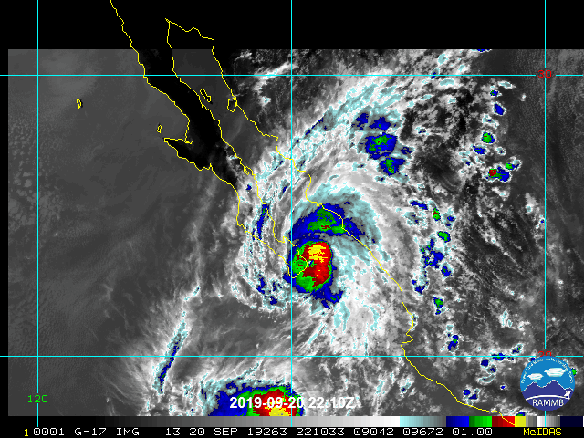
Satellite loop of Lorena (water vapor) ending 0010UTC September 21. Source: NOAA/NESDIS.
Meteorological Discussion
According to advisories of the National Hurricane Center (NHC), Lorena was first classified as a tropical storm at 11 AM EDT (15 UTC) September 17, about 295 miles south-southeast of Zihuatanejo, Mexico. The first tropical storm watches were issued at this time and were upgraded to warnings just six hours later. Hurricane warnings were then issued at 11 AM EDT (15 UTC) the morning of September 18, before the storm was upgraded to a category-1 hurricane just twelve hours later. By the early morning of September 19, Lorena approached the central Pacific Coast of Mexico as a category-1 hurricane with maximum sustained winds of 75 mph. The hurricane continued to move near or over the coast within 25 miles of Manzanillo and 15 miles of Cabo Corrientes. Lorena was downgraded to tropical storm status at 11 AM EDT (15 UTC) September 19 at which time tropical storm watches were then issued for portions of the Baja California Peninsula. Lorena then moved offshore and towards the southern tip of the Baja California Peninsula; hurricane warnings were issued for the area at 11 PM EDT (03 UTC September 20).
After moving over warm waters, Lorena was again upgraded to a category-1 hurricane at 5 AM EDT (21 UTC) September 20. The hurricane was moving to the west-northwest at the time between a subtropical ridge to the north and nearby Tropical Storm Mario to the south. As Lorena approached within 35 miles of Cabo San Lucas, it gained intensity with a central pressure of 987 mb after moving over warm waters. The wind speeds responded to the drop in pressure with a slight gain in maximum sustained winds to reach 85 mph as of 5 PM EDT (21 UTC) September 20. The hurricane had stalled by this time in response to shifting steering currents. A few hours later the hurricane began to move to the north-northwest through a developing weakness in the subtropical ridge. The center of circulation passed near or over the Cabo Pulmo area in the meantime.
Lorena than made landfall near La Ventana, Mexico around 12 AM EDT September 21 (00 UTC September 21), according to NHC advisories. At the time of landfall Lorena was a category-1 hurricane with maximum sustained winds of 80 mph and a central pressure of 986 mb. The center of circulation then moved back into the Gulf of California early September 21. That afternoon at 3 PM EDT (19 UTC) Lorena was downgraded to a 50 mph tropical storm, after aircraft reconnaissance revealed a severely degraded storm structure after it crossed the Peninsula. Lorena further weakened to a tropical depression with 35 mph winds as of 5 AM EDT (09 UTC) September 22, at which time all remaining tropical watches and warnings were cancelled by the NHC. The center then moved onshore on the mainland before eventually dissipating. The remnants of Lorena would continue to pose a threat for heavy rainfall for portions of northwest Mexico and the southwest United States.
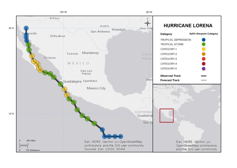
Hurricane Lorena Track and Position Reports. Source: National Hurricane Center.
Impacts
According to initial media reports, damage to the resort areas of Cabo San Lucas and San Jose del Cabo was less severe than expected as Lorena took a late turn to follow along the eastern shore of the Peninsula. Nevertheless, a number of homes were flooded due to heavy rainfall and some property damage due to wind was reported, along with some power outages. Road damage and power loss also affected San Juan de Los Planes, La Paz and La Rivera. Storm preparations included some evacuations and 787 people who took refuge across 18 shelters. The port in Los Cabos was closed and classes were suspended at area schools.
Further south in the Mexican State of Colima downed trees and powerlines were reported along with resulting power outages. Flooded streets were also reported due to heavy rainfall along with some mudslides and road damage. State officials reported damage to about 7,400 acres of crops including bananas and papayas.
Meanwhile in southwest United States, flood impacts were reported in portions of Phoenix with some inundation of homes, roadways and cars reported. Some water rescues were necessary in Apache Junction, about 36 miles east of Phoenix where a mobile home park also suffered inundation. Some minor structural damage was reported.
Sources: U.S. National Hurricane Center, Los Angeles Times, NF News Center, Associated Press, The Weather Channel.