

Wildfire season reached its typical national peak in August, characterized in 2019 by below normal activity in most areas. The low activity was primarily due to monsoon associated precipitation, which brought adequate although not abundant moisture to fire prone areas. The month of September has seen the majority of North America exit wildfire season, which is traditional as daylight hours shorten, temperatures cool off, and eventually snowfall activity increases. The exception to this rule is California, where seasonal Santa Ana winds can influence fire into the fall months, especially when combined with drying fuel conditions.
Current Fire Conditions
- There are currently 3 large and uncontained fires burning in the United States, none of which are immediately threatening structures
- To date, the number of fires in 2019 is less than any other year in the past decade, except 2013
- To date, the acreage burned in fires in 2019 is on par with average, and is significantly less than the past two years
- The below average fire activity thus far in 2019 is linked to abundant spring moisture which kept live fuel moisture rates low, while temperatures were also 2-7 degrees below average across the western United States
- An active seasonal monsoon has curtailed fire activity in the southwestern United States, however it also caused lightning fires across the Great Basin and Northern Rockies in mid-September that remain burning
[caption id="attachment_47991" align="aligncenter" width="650"]
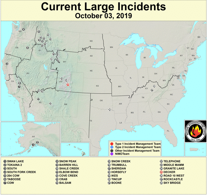
Current Large Incidents as of October 3, 2019 (National Interagency Coordination Center)[/caption] [caption id="attachment_47981" align="aligncenter" width="689"]
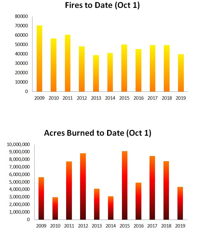
Year to Date Number of Fires and Acreage Burned as of October 1. Source: NIFC[/caption]
Drought Conditions & Forecast
- Overall drought coverage increased substantially in the past month, most notably in the southern and eastern United States
- Currently, 19% of the United States is classified as being in some state of drought, with 6% in a severe to exceptional drought, brought on quickly by extreme late summer heat
- A very weak southwest monsoon created the moderate to severe drought conditions that emerged over the past month in Arizona and New Mexico
- Approximately 2% percent of California is rated as experiencing drought conditions, confined to the southern portion of the state
[caption id="attachment_47993" align="aligncenter" width="650"]
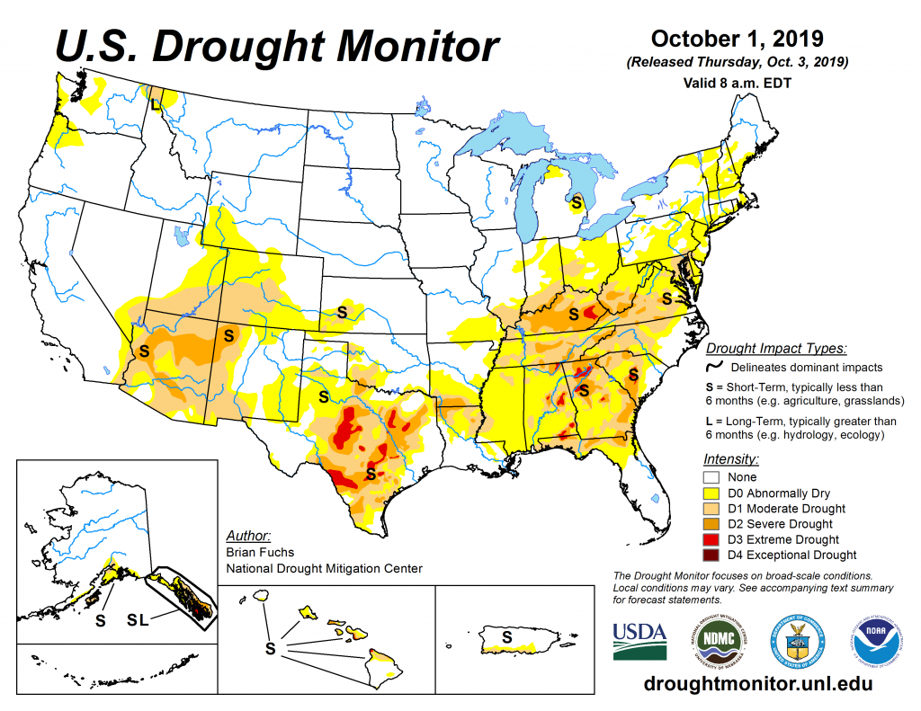
US Drought Monitor as of Oct 1, 2019[/caption] [caption id="attachment_47994" align="aligncenter" width="650"]
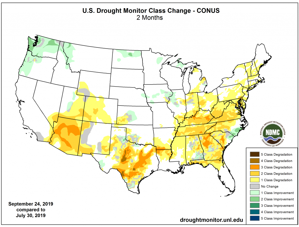
2 Month Drought Tendency[/caption] [caption id="attachment_47985" align="aligncenter" width="650"]
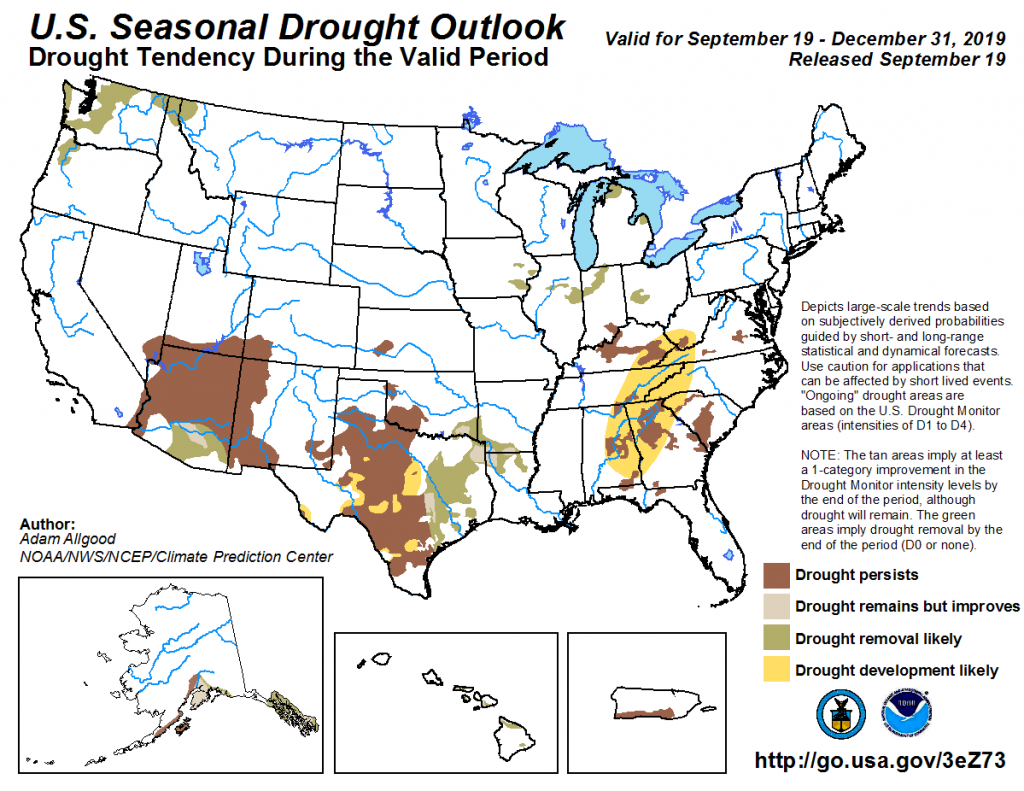
US Monthly Drought Outlook Valid October 2019. Source: NOAA[/caption]
Climatological Outlook
- The three month temperature outlook favors above average temperatures across the entire United States, with forecast confidence highest in the southwest and portions of Alaska
- Above average to average precipitation is forecast for the balance of the United States over the next three months, with a notable precipitation deficit forecast for coastal and inland areas of Northern California and Southern Oregon
- The combined precipitation and temperature outlook moving into October indicates an increasing, although not extreme, risk for fall season wildfire for California
[caption id="attachment_47987" align="aligncenter" width="650"]
Three month temperature outlook, valid October, November and December 2019. Source: NOAA[/caption] [caption id="attachment_47986" align="aligncenter" width="650"]
Three month precipitation outlook, valid October, November and December 2019. Source: NOAA[/caption]
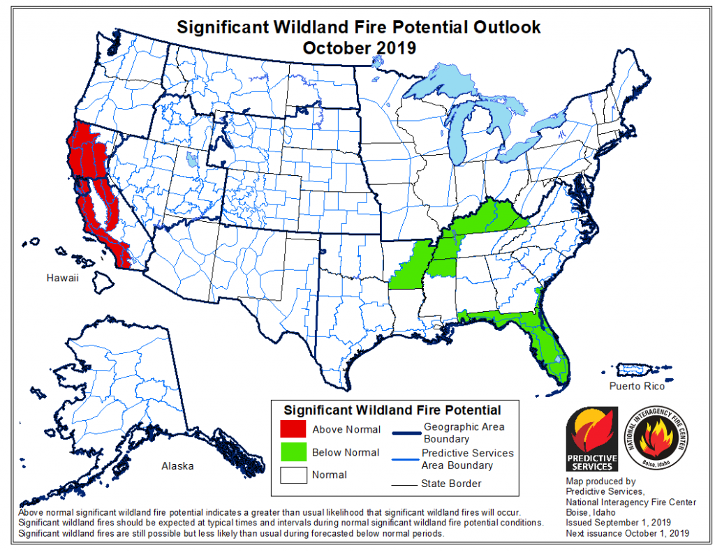
Significant Wildfire Outlooks
- With fall weather dictating an end to wildfire season for much of the United States, the focus turns to California, where seasonal dryness and the onset of Santa Ana winds can influence wildfire
- Santa Ana wind season typically lasts from late September until December, characterized by strong offshore flow, and most weather models agree there will be average to slightly above average Santa Ana wind activity this season
- The months of August and September were abnormally dry in California, causing fuel moisture levels to decrease steeply
- Despite the wet spring and early summer, finer fuels have dried out in late summer and are quite receptive to fire across most of the state
- Large fire potential is expected to be above average in the state of California through December, with the most significant threat in the coastal ranges where the Santa Ana wind influence is the strongest
- It should be stressed that significant wildfires may still occur in regions forecast for normal or below normal potential
[caption id="attachment_47997" align="aligncenter" width="531"]
Percent of Average Precipitation for Month of September in California (NOAA)
[/caption] [caption id="attachment_47988" align="aligncenter" width="650"]
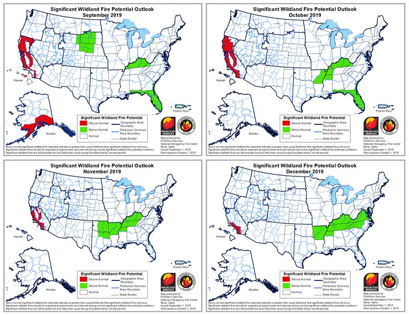
Significant Wildland Fire Potential Outlook. Source: Predictive Services and NIFC[/caption] This report was compiled with integrated information from the public agencies listed below. Regional conditions can vary depending on local weather conditions. Interested parties can monitor the sites below for updates and developments, and statements from these sites supersede this update.
US National Weather Service Climate Prediction Center
National Interagency Fire Center/National Interagency Coordination Center