

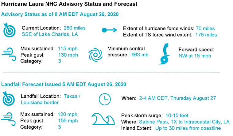
Hurricane Laura poses an escalating threat for both wind and storm surge impacts for southwest Louisiana and southeast Texas. The storm should move ashore as a destructive major hurricane very early Thursday morning. Impacts to property and infrastructure will affect a large area extending well inland and away from the track, and will be most severe along and to the right of the immediate track.
- Hurricane Laura is forecast by the NHC to strengthen to a category-4 hurricane over the coming hours. Some weakening may occur as the storm moves ashore, and landfall is forecast by the NHC as a strong category-3. Onset of conditions will occur over the coming hours, and landfall is forecast for very early Thursday morning.
- The winds of a major hurricane combined with the size of the storm will render hazards of destructive winds, storm surge and heavy rainfall for areas extending well away from the center of circulation.
- Expected wind impacts include downed trees and power lines with resulting power outages and transportation disruption, along with variable wind damage over areas extending well inland, and well away from the center of circulation. More severe impacts to property and infrastructure will be rendered to those areas near and to the right of the core of the storm. Tornado activity will bring localized severe impacts as the storm approaches the coast.
- Storm surge is forecast to reach levels as high as 10-15 feet. Destructive impacts to property and infrastructure are likely for the most severely affected areas along the coast and adjacent waterways, in some cases well inland from the coast. Damage due to seawater inundation, water velocity and wave battering along the coast are likely impacts.
- Heavy rainfall amounts of 5-10 inches, with isolated amounts to 15 inches will bring the threat of flooding and flash-flooding for areas well inland.
Expert Discussion
As discussed in the Weather Sentinel discussion from yesterday, the conditions for rapid intensification (RI) were present yesterday in the Gulf of Mexico. Indeed, Hurricane Laura took advantage of the warm ocean and low shear environment to rapidly intensify to a category-3 major hurricane overnight. According to the NHC, “The hurricane has intensified a remarkable 40 knots (46 mph) during the past 24 hours, and there are no signs it will stop soon.” The shear environment remains favorable for intensification, and there is no shortage of warm water along Laura’s path.
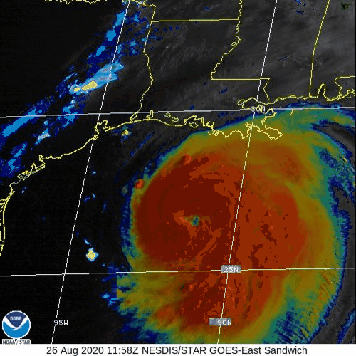
VIS/IR Sandwich Satellite Loop. Combines the cloud top detail of the visible channel, with the temperature information of the IR. Note the emerging eye and the broad thunderstorm activity in the cloud tops. Source: CIMSS.
Model intensity guidance shows a steady increase in wind speed for the next 12 hours prior to landfall. Several forecast models keep Laura at category-4 strength at landfall, however the NHC official forecast calls for a high-end category-3 hurricane at the time of landfall. If Laura were to maintain category-4 strength through landfall, only 18 hurricanes have made a continental US category-4 since 1851, with the most recent in Louisiana Hurricane Audrey from 1957. Track guidance is tightly clustered at this point around the Texas/Louisiana border lending higher confidence to the track forecast. Storm motion has subtly shifted to the northwest, with further shifts to the north expected as Laura navigates around the western edge of a high.
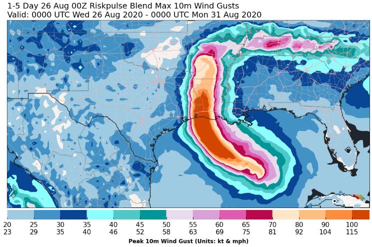
Model wind gust footprint for Hurricane Laura. Source: Riskpulse.
Concerning the escalating storm surge threat, the track forecast has not shifted the regions of maximum surge inundation. However, the increased strength of the storm has increased maximum predicted surge levels. Maximum surge inundation is now expected to be 10-15 feet in the region between Sea Rim State Park, Texas and Vermillion Bay, Louisiana with inland lakes in the region such as Sabine Lake and Calcasieu Lake also expected to be affected by 10-15 feet of surge. In Texas, Galveston Island and Galveston Bay are now forecast to see surge levels reach 3-5 feet. The NHC Probabilistic Tropical Storm Surge (PSurge) product considers uncertainty in forecast track and intensity to provide exceedance probabilities of surge elevations. For Advisory 26 (5 AM EDT August 26) PSurge indicates a 10 percent probability peak surge from Laura will exceed 17-19 feet in the region of landfall and 50 percent probability peak surge will exceed 7-9 feet.
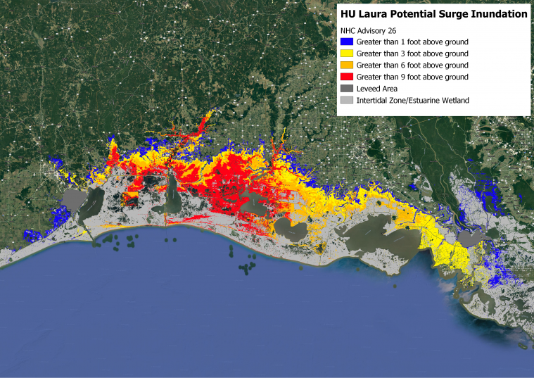
Potential Storm Surge Flooding for Hurricane Laura based on NHC Advisory 26 (5 AM EDT August 26). Potential Storm Surge Flooding does not depict the forecast surge inundation for an event, rather the 10 percent exceedance flood depth based on uncertainty in forecast track and intensity. Source: NOAA/NHC.
Updates and Useful Links
Email alerts for Weather Sentinel and CAT-i reports are available on a subscription basis at the GC Preference Center here.
Daily, global tropical cyclone alerts are also available on a subscription basis here.
U.S. National Hurricane Center
Local Products Associated with Hurricane Laura
NOAA Satellite of Hurricane Laura
American Meteorological Society COVID-19 & Hurricane Evacuation Guidance
Official statements from the NHC and U.S. National Weather Service, and those of emergency management agencies supersede this update, and should be closely monitored concerning matters of personal safety.