

Hurricane Sally is now drifting in the northern Gulf of Mexico as a category-1 hurricane, and expected to begin a slow turn to the northeast over the coming hours. The hurricane is forecast to make landfall very early Wednesday morning. The slow forward motion of the system will bring prolonged periods of heavy rainfall to amplify the threat for inland flooding. Wind impacts with downed trees and powerlines and variable property damage, and seawater inundation due to storm surge are also active threats. Conditions are already worsening on the northern Gulf coast.
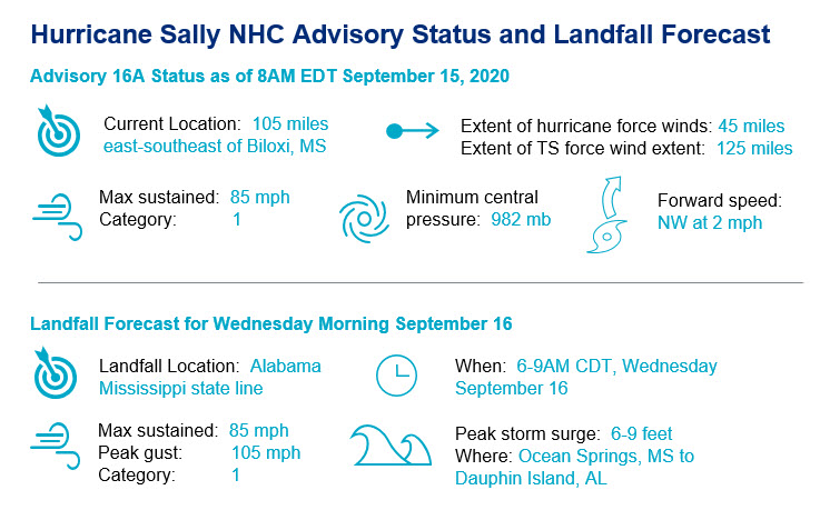
- Intensity Changes and Status: This morning, Sally has weakened back to category-1 status in an environment of increasing wind shear, and possible upwelling of cooler waters as the hurricane drifts over the northern Gulf. This comes after a period of rapid intensification yesterday as Sally was upgraded by the National Hurricane Center (NHC) to hurricane status shortly after 11 AM EDT Monday and then to category-2 strength by 5 PM EDT. Sally was able to aggressively gain strength yesterday over very warm waters, in an environment of reduced wind shear and good storm ventilation.
- Slow moving hurricane: The storm has slowed to a drift in a west-northwesterly direction, in a region with very weak steering currents between two adjacent areas of high pressure. As steering currents build with a passing weather system, Sally should make a sharp turn to the north and east through Wednesday.
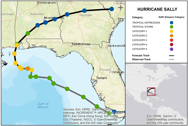
- Landfall slightly further east and a bit later: Accounting for these factors, the NHC best forecast takes the center of circulation inland early Wednesday near the Alabama-Mississippi Line, most likely as category-1 hurricane. Given the slow forward motion of the storm and the sensitive timing of the turn, there is still some uncertainty in the forecast track.
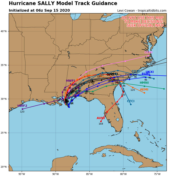
Hurricane Sally Model Track Guidance (06 UTC September 15). Source: Tropical Tidbits.
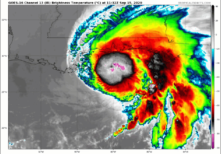
Satellite (infrared band) imagery of Sally (11 UTC September 15). Source: NOAA/NESDIS.
Updated Impacts Discussion
- Wind damage: Winds of a category-1 hurricane, to bring downed trees and powerlines with resulting power outages to a widespread area, along with some property damage. Impacts will be more severe along and to the right of the track of the storm, and more so for older structures or those not built to more resilient codes. Tornado activity on the outer bands and near the core will also render impacts.
- Inland flooding: Excessive rainfall amounts as high as 10-20 inches, with isolated amounts to 30 inches are possible, due to slow movement of the storm as it moves inland. The resulting freshwater flood effects will cause considerable damage to affected property and infrastructure including inundation as well as damage due to water velocity and waterborne debris.
- Storm surge: Storm surge as high as 6-9 feet can be expected. This will bring damage to property and infrastructure due to seawater inundation, water velocity and waterborne debris, and wave battering. Effects will be most severe along and some distance to the right of the track. The storm surge will also prevent drainage of river basins and stormwater management systems in the area, which could well amplify the flood threat for areas well inland from the immediate coast.
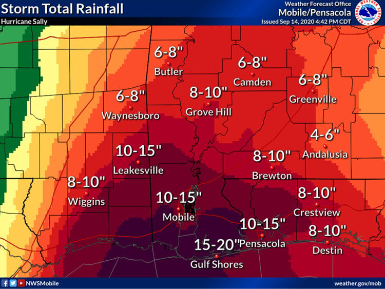
Storm Total Rainfall Forecast for Mississippi/Alabama. Source: NOAA/NWS Mobile.
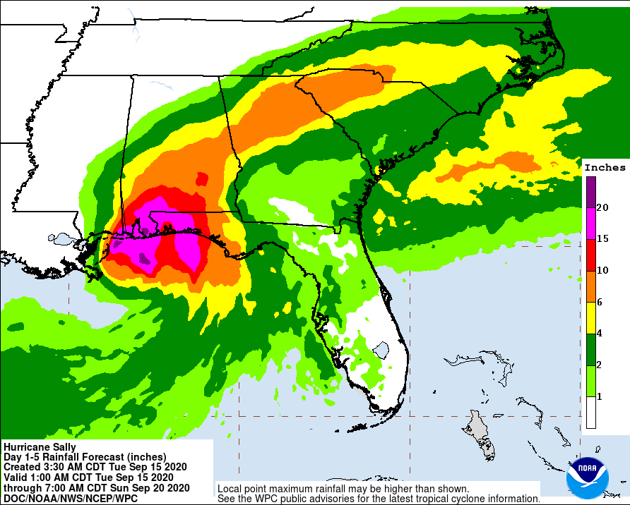
5-Day precipitation forecast through 8 AM EDT September 20. Source: NOAA/NHC.
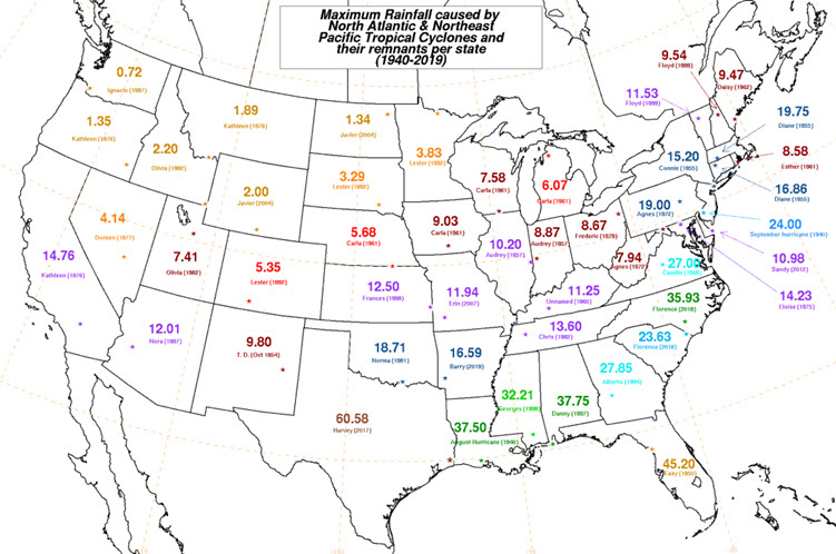
State precipitation records from tropical cyclones. Source: NOAA/WPC.
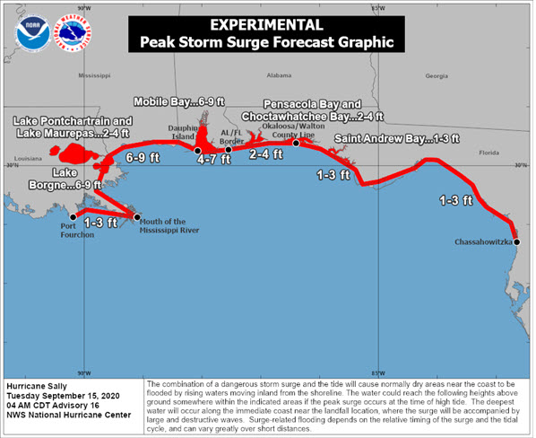
NHC Experimental Peak Storm Surge Forecast for Sally. Source: NOAA/NHC.
The Rest of the Basin
The Atlantic Basin continues to remain very active, with the earliest “V”-named storm in the known historical record declared yesterday. Other than Sally, significant impacts to land are not apparent within the next five days. The numerous systems in the Atlantic will continue to be monitored for any longer term implications.
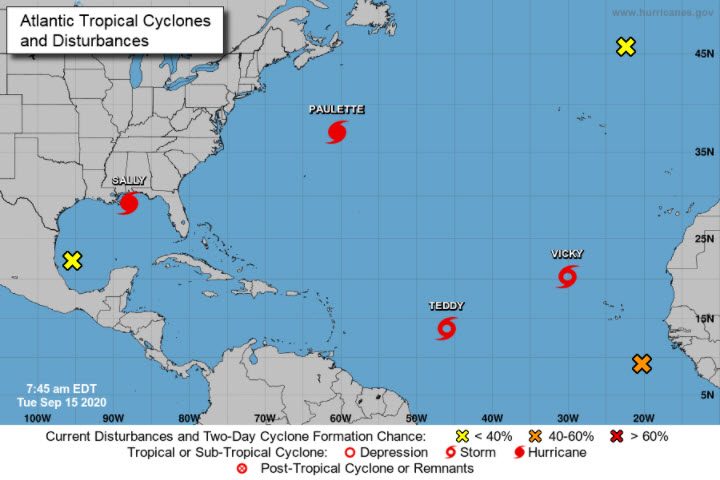
Active named storms in the Atlantic basin as well as storms with formation potential in the next five days. Source: NOAA/NHC.
Updates and Useful Links
Email alerts for Weather Sentinel and CAT-i reports are available on a subscription basis at the GC Preference Center here.
Daily, global tropical cyclone alerts are also available on a subscription basis here.
U.S. National Hurricane Center
Official statements from the NHC and U.S. National Weather Service, and those of emergency management agencies supersede this update, and should be closely monitored concerning matters of personal safety.