


Tropical Storm Sally official forecast Source: NHC and Guy Carpenter.
Tropical Storm Sally continues to track slowly toward the Central Gulf Coast and is expected to take advantage of warm waters and low wind shear to strengthen into a hurricane prior to landfall. At the peak of hurricane season, Sally is one of five systems currently active in the Atlantic, including Hurricane Paulette that made landfall in Bermuda this morning.
- There was a notable shift to the east in the track overnight, which does improve the wind and surge outlook for New Orleans, with the worst impacts along and to the right of the landfall location in Mississippi and Alabama. However, rainfall remains the main threat over a very wide area both coastal and inland.
- Significant bursts of convection and lightning activity in the past several hours near the center of circulation are indicative of strengthening; however the storm is still fairly asymmetrical and struggling to get highly organized. The increasing convection over warm waters and in a low shear environment should ensure that Sally transitions from a strong tropical storm to a category-1 hurricane within the next few hours.
- The NHC official forecast brings Sally onshore as a category-1 hurricane just east of New Orleans along the Mississippi coast Tuesday morning. The timing of this turn to the north is highly uncertain, and there is an unusual amount of spread in the ensemble track guidance for a near-term landfall. Sally will be moving very slowly as it makes landfall, increasing the potential for rainfall impacts.

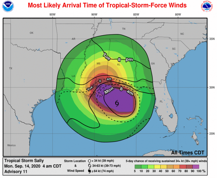
Most likely arrival time of tropical-storm force winds; Tropical Storm Sally. Source: NOAA/NHC.
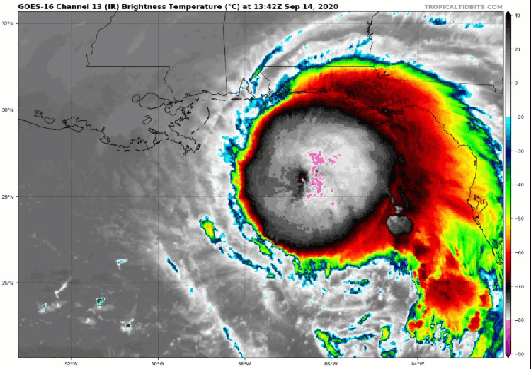
Satellite (infrared band) imagery of Tropical Storm Sally. Source: Tropical Tidbits.
EXPECTED IMPACTS FROM SALLY
- Winds of a category-1 hurricane, to bring downed trees and powerlines with resulting power outages to a widespread area, along with variable property damage. Impacts will be more severe along and to the right of the track of the storm, especially for older structures or those not built to more resilient codes.
- Excessive rainfall amounts as high as 8-16 inches, with isolated amounts to 24 inches due to the expected slow movement of the storm as it moves inland. The resulting freshwater flood effects will cause considerable damage to affected property and infrastructure including inundation as well as damage due to water velocity and waterborne debris.
- Analog rainfall events for the Louisiana coastline that are more severe than current forecast expectations, but not out of the realm of possibility of rainfall totals in excess of 30” include the warm-core low pressure system of 2016, Hurricane Georges (1998), Tropical Storm Danny (1997), and August 1940.
- Storm surge as high as 7-11 feet, to bring damage to property and infrastructure due to seawater inundation, water velocity and waterborne debris, and wave battering. Effects will be most severe along and to the right of the track. The storm surge will also prevent drainage of river basins in the area as well as stormwater management systems, which could well amplify the flood threat for areas well inland from the immediate coast.
- Soils in the region are already extremely saturated, with soil moisture anomalies of 3.2-4.0 inches (80-100 mm) for the past month. With soils so wet, there is little absorption capacity, leading to greater runoff and flooding potential. Saturated soils also increase the vulnerability of trees to toppling in high winds.
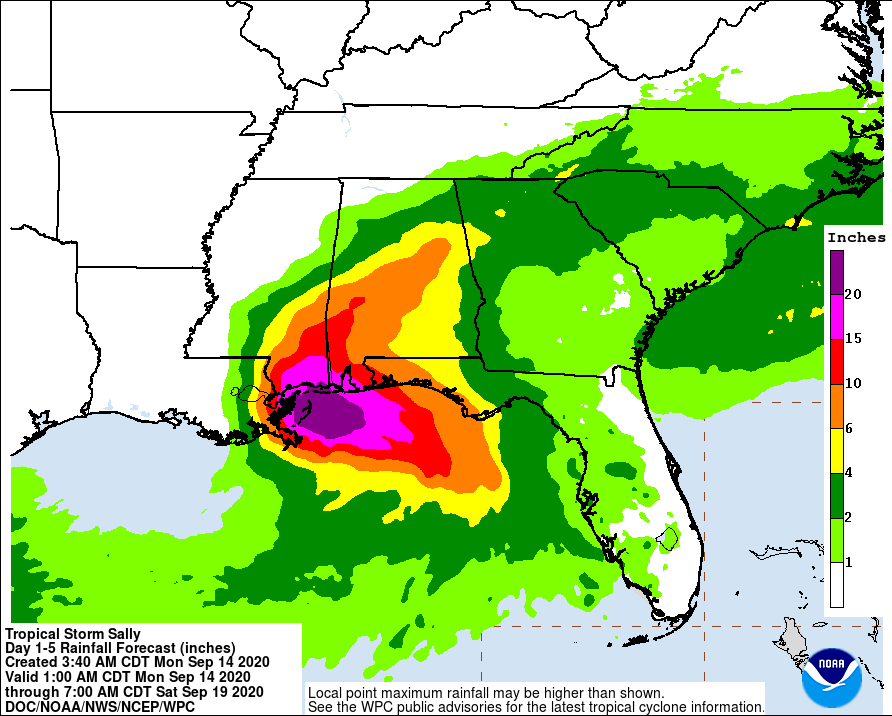
Tropical Storm Sally 5 day rainfall forecast. Source: NOAA/NWS.
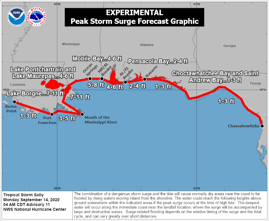
The NHC experimental Peak Storm Surge Forecast for Sally. Source: NOAA/NHC.

Soil Moisture Anomaly, showing an 80-100 mm positive monthly rainfall anomaly in the region of Sally landfall. Source: NOAA/CPC.
Hurricane Paulette
- Hurricane Paulette made landfall in Bermuda as a category-1 hurricane with 90 mph winds sustained, and gusts to 115 mph.
- The eye of the hurricane passed over the island around 6 am this morning, with the northern and southern eyewalls impacting the island directly.
- Hurricane conditions should subside throughout the day today, when damage from wind, rain and surge can be further assessed.
Hurricane Paulette Track and Forecast. Source: NOAA/NHC.
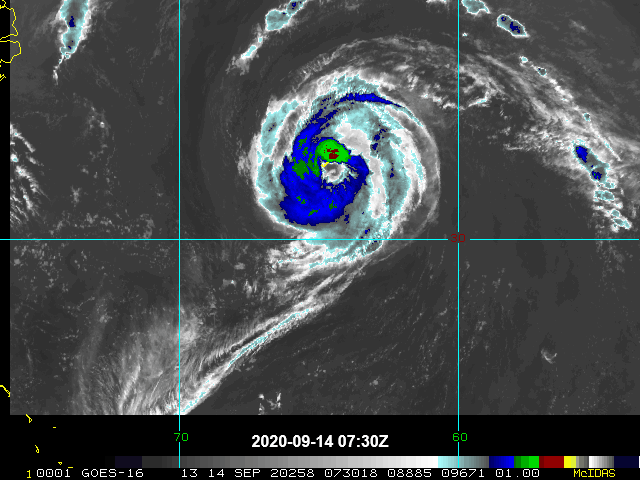
Satellite image (infrared band) of Hurricane Paulette with the eye over Bermuda. Source: NOAA/NHC.
The Hyperactive 2020 Season Continues
Beyond Sally and Paulette, Teddy formed overnight in the deep tropical Atlantic as did Tropical Depression #21. Teddy, the 19th named storm in the 2020 Atlantic season, is weeks ahead of the prior record of October 4th in 2005. All in, there are five active systems in the Atlantic, which has only been seen one other time in the satellite era, in September of 1971, when six named storms were observed simultaneously. None of the additional storms being monitored are anticipated to have short-term impacts to land and will continue to be monitored for any longer term implications.
Additional Links:
U.S. National Hurricane Center
Official statements from the NHC and U.S. National Weather Service, and those of emergency management agencies supersede this update, and should be closely monitored concerning matters of personal safety.