

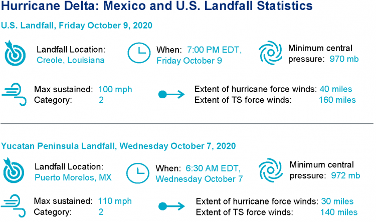
Hurricane Delta made landfall near Creole, Louisiana on October 9 as a category-2 hurricane, with maximum sustained winds of 100 mph. Delta moved ashore just east of where Hurricane Laura made landfall in September and impacts were amplified for those areas still recovering from Laura. Delta also brought a threat for heavy rainfall and flooding from Louisiana to the Carolinas. Delta is the fifth hurricane to make landfall on the Continental U.S. this year. Earlier in the week Delta made first landfall near Puerto Morelos on the Yucatan Peninsula as a category-2 hurricane with 100 mph winds. Significant impacts were reported due to storm surge, heavy rainfall and destructive winds.
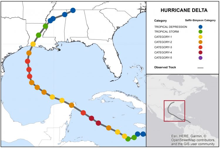
Hurricane Delta Track and Position Reports. Source: NOAA/NHC.
This report comprises the following sections:
- Regional Impacts
- Notable Impacts by Sector
- Key Dates in the Timeline
- Physical Discussion with Peak Meteorological Statistics
Regional Impacts
Impacts Discussion
Louisiana
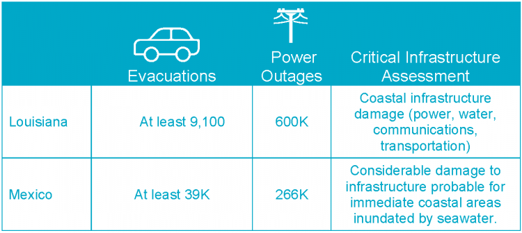
According to media reports, widespread flooding occurred throughout much of southwest Louisiana after more than 15 inches of rain fell at Lake Charles and 10 inches at Baton Rouge. Those parishes suffering impacts from Hurricane Laura were severely affected, including Cameron, Jefferson Davis, Vermillion and Acadia. More than 600,000 homes and businesses were without power, but electricity was restored to nearly half of those customers by Sunday. Over 9,000 residents were still in emergency shelters or temporary housing as of Sunday morning. Downed trees and powerlines with variable property damage were reported well inland, including Baton Rouge. In Jennings, a church steeple was toppled. The storm has also been blamed for one fatality as an elderly man was killed by a fire resulting from refueling a generator. Around 3,000 National Guard troops were called in to support immediate recovery efforts.
Georgia
Dozens of tornado warnings were issued through the state on Saturday, with six tornado reports. Reports indicate damage to Newman high school in Coweta Co., with downed trees and powerlines across the county. Damage was also reported for a homeless shelter in Newton Co.. Flooding and flash-flooding was reported in many areas of the state including Roswell, Georgia. Swift water rescues were also necessary in Gwinnett.
South Carolina
Possible tornadoes brought damage across northeastern parts of the state, including a damaged roof in Conway and downed trees in Dillon and Latta. At least 1,500 customers were reported to lose electricity.
Mexico
No deaths or injuries have been reported to date in Mexico. However, media reports indicate about 39,000 people were evacuated in the states of Quintana Roo and Yucatan. About 2,700 people sought refuge in storm shelters, including hundreds of tourists. Power outages affected an estimated 266,000 customers, roughly one-third of the Yucatan Peninsula. Strong winds brought down over a thousand trees, and moderate flooding was reported in Cozumel and Playa del Carmen. Around 5,000 military personnel were deployed to Quintana Roo and Yucatan ahead of the storm.
Initial Loss Estimates
While initial loss estimates are still developing, media reports indicate estimated insured losses of around USD 2 billion, as reported by Demex group.
Notable Impacts by Sector
Key Dates in Timeline of Hurricane Delta
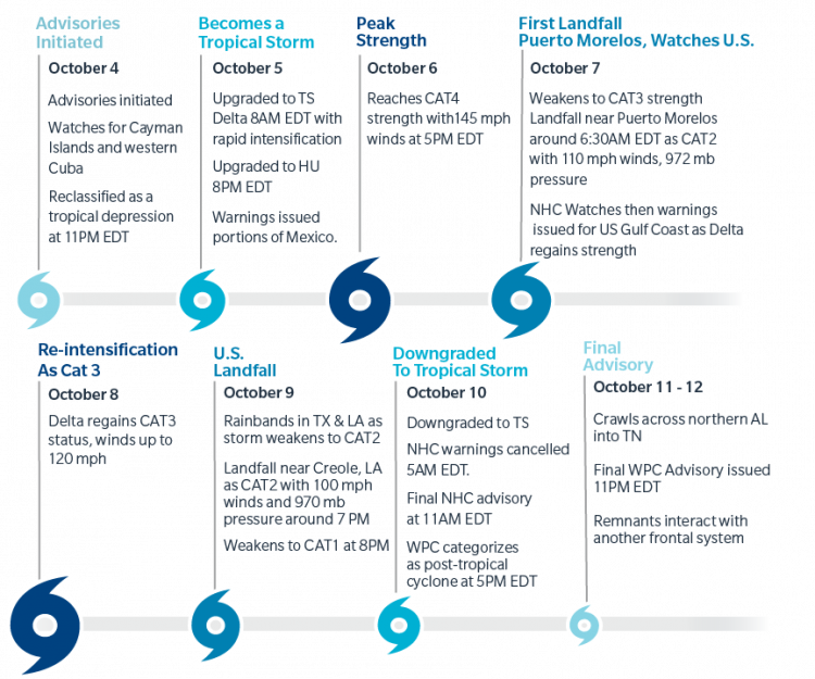
Timeline of Hurricane Delta following advisories of the NHC. All times EDT.
Physical Discussion
The general timeline of Hurricane Delta is shown above, following advisories of the National Hurricane Center. Key aspects defining Hurricane Delta follow below.
1) Historical Significance:
- Fifth hurricane to make landfall on the Continental U.S. in 2020, the first time this has occurred since 2005.
- Tenth named storm to make landfall on the Continental U.S., surpassing the previous record dating back to 1916.
- Fourth named storm to make landfall in Louisiana, tying 2002 for the most of the known historical record since 1851.
- First Greek alphabet named storm to make landfall on the Continental U.S., and the strongest of the known historical record since 1851, surpassing Hurricane Beta (2005).
- Hurricane Delta was the 25th named storm in the Atlantic Basin for the 2020 season, the earliest of the known historical record since 1851. Delta was named by the NHC on October 5th, 2020, in contrast to 2005 where Tropical Storm Delta was named on November 23, 2005.
- Delta made landfall just east of Hurricane Laura.
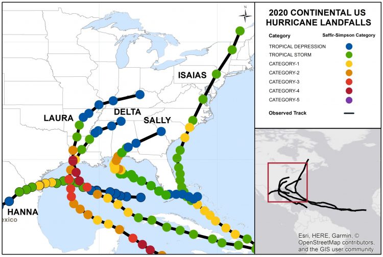
Continental U.S. Hurricane Landfalls as of October 12, 2020. Source: NOAA/NHC.
2) Rapid intensification (again):
Delta was named by the NHC as a tropical storm with maximum sustained winds of 40 mph, at 8AM EDT October 5. Exactly 24 hours later, Delta carried winds of 110 mph, a remarkable gain of 70 mph over a 24 hour period. Just a few hours later at 5PM EDT Delta reached its peak strength with maximum sustained winds of 145 mph, a strong category-4 on the Saffir-Simpson Scale. High ocean heat content and reduced wind shear were key contributors to this explosive gain in strength. The storm went on to weaken while approaching the Yucatan Peninsula before making landfall as a category-2 hurricane. Delta was able to regain some strength over the Gulf of Mexico after clearing land, reaching another peak as a category-3 hurricane. Cooler waters and increasing wind shear led to weakening on final approach to the northern Gulf Coast.
3) Heavy Rainfall:
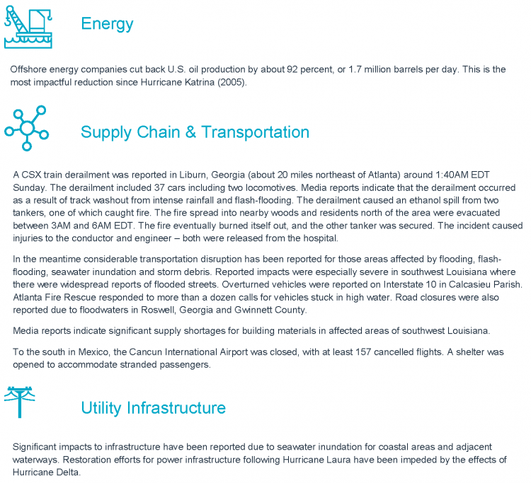
Heavy rainfall affected areas of southwest and central Louisiana. The U.S. National Weather Service (NWS) recorded almost 17.6 inches of rain in Calcasieu Parish in a 48-hour period on October 10. The Lake Charles area and Evangeline Parish experienced flash flooding as a result. Heavy rain also increased levels of the Calcasieu River and Mermentau River, and both are expected to remain up to two feet above major flood stage at Kinder and White Oak Park for the next few days. In the meantime Delta also impacted areas from the southern Mississippi River Valley into the Tennessee Valley, with heavy rainfall and flooding an ongoing concern. Flooding has been reported in the Atlanta, Georgia Metropolitan area. The NOAA gauge at Peachtree Creek at Atlanta, Georgia jumped from only 4 feet to over 20 feet over the weekend, and is now above major flood stage with riverine flooding in the area.
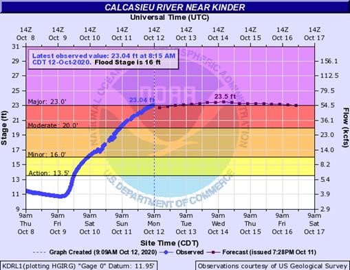
Flood Gauge at Calcasieu River near Kinder, Louisiana. Source: NOAA/NWS.
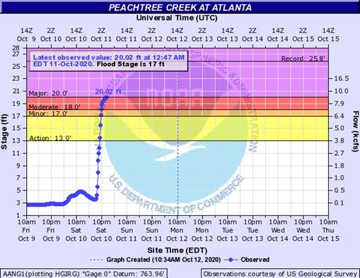
Flood Gauge at Peachtree Creek at Atlanta, Georgia. Source: NOAA/NWS.
4) Storm surge:
The relatively fast approach to the Louisiana coast limited the amount of time the surge had to penetrate inland along the central Louisiana coastal marshes. Peak surge levels for Delta likely occurred along the Louisiana coastline in the Rockefeller Wildlife Refuge to the east of Grand Chenier, LA, where surge levels are estimated to have reached 9 to 11 feet above NAVD88 datum, based on Coastal Emergency Risk Assessment (CERA) modeling. This estimate is corroborated by an observation at a NOAA gauge at the U.S. Army Corps of Engineers Freshwater Canal Locks station, just to the east of the estimated peak surge location. At this site, water surface elevation levels reached 9.19 feet above NAVD88 datum at approximately 7PM EDT October 9 before the gauge failed (indicating higher surge levels possibly occurred at this location). To the east of the Freshwater Canal Locks significant surge was generated in the shallow waters of Vermillion Bay. CERA estimates surge elevations reached approximately 7 feet above NAVD88 datum near Avery Island, LA, and a USGS gauge in Vermillion Bay near Cypremort Point recorded a water surface elevation of approximately 7.9 feet. Data collection at the station was sporadic at the time of landfall indicating higher surge elevations may have occurred. Away from the immediate region of landfall at a NOAA gauge at Sabine Pass, Texas, surge levels reached a maximum of approximately 4 feet above NAVD88 datum before the passage of the eye and the associated change in wind direction caused a drawdown of water levels to approximately 1.7 feet below NAVD88 datum. At Galveston Island, Texas surge reached 3.6 feet above NAVD88 at a NOAA observation gauge at Galveston’s Pier 21. To the east of landfall, based on NOAA gauge observations, surge levels reached approximately 2.7 feet above NAVD88 datum on the south shore of Lake Pontchartrain in New Orleans and approximately 4.5 feet above NAVD88 datum at Bay St. Louis, MS.
5) Tornadoes: The outer rainbands of Hurricane Delta brought a modest tornado potential from the northern Gulf States to the Carolinas. Numerous tornado warnings were issued for areas under threat, with thirteen tornado reports per the U.S. Storm Prediction Center.
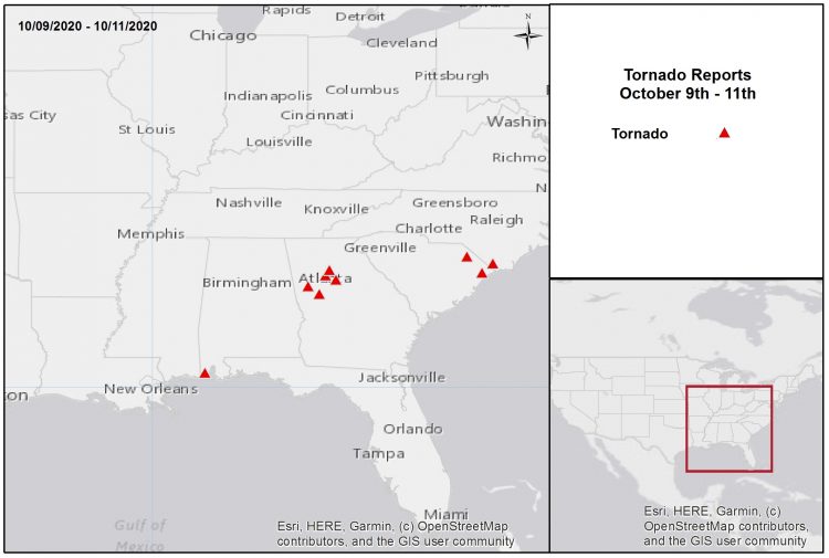
Tornado Reports October 9-11. Source: NOAA/SPC.[/caption] Peak Meteorological Statistics
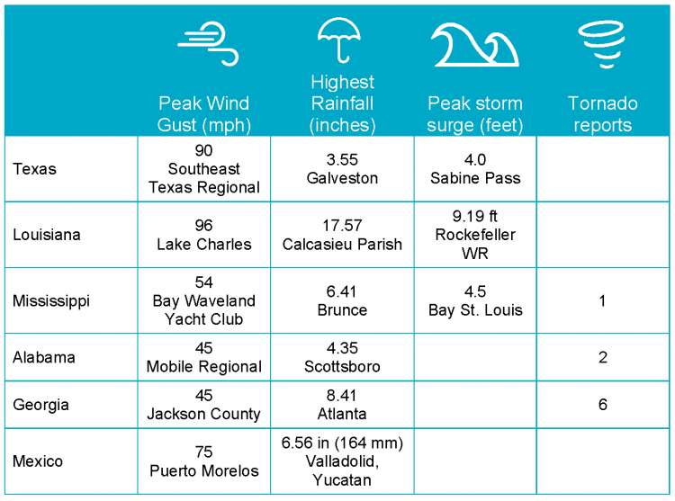
Note: Storm surge elevations are all above NAVD88 datum. Highest rainfall and wind gusts reported by AWOS/AFOS weather stations. All observations preliminary and unofficial.[/caption] Sources: Reuters, The Weather Channel, Associated Press, U.S. National Hurricane Center, U.S. National Weather Service, U.S. Weather Prediction Center, U.S. Storm Prediction Center.